Tag Archives: hail

Half of Indiana has marginal risk of severe storms today

Indiana map showing (Left) Risk of severe weather between 9 a.m. EDT today and 8 a.m. EDT tomorrow. Dark green shading: Marginal risk. Light green: thunderstorms possible but none expected to be severe. (Center) Probability of damaging straight-line thunderstorm winds of 58 mph or stronger within 25 miles of any point. Brown: 5% (marginal risk). Unshaded: Less than 5%. (Right) Probability of hail of one inch diameter or larger within 25 miles of any point. Brown: 5% (marginal risk). Unshaded: Less than 5%. Source: SPC "Day 1 Convective Outlook" issued at 8:52 a.m. EDT.
(Left) Risk of severe weather between 9 a.m. EDT today and 8 a.m. EDT tomorrow. Dark green shading: Marginal risk. Light green: thunderstorms possible but none expected to be severe. (Center) Probability of damaging straight-line thunderstorm winds of 58 mph or stronger within 25 miles of any point. Brown: 5% (marginal risk). Unshaded: Less than 5%. (Right) Probability of hail of one inch or more in diameter within 25 miles of any point. Brown: 5% (marginal risk). Unshaded: Less than 5%. Source: SPC “Day 1 Convective Outlook” issued at 8:52 a.m. EDT. Click the image for a larger version.

Half of Indiana (shaded in dark green on the map, above-left) has a marginal risk of severe thunderstorms between 9 a.m. EDT today and 8 a.m. EDT tomorrow, according to the “Day 1 Convective Outlook” that the National Weather Service Storm Prediction Center (SPC) issued at 8:52 a.m.

The primary risks are damaging straight-line thunderstorm winds of 58 mph or stronger and hail of one inch or more in diameter. The probability of either occurring within 25 miles of any point in the slight risk area is five percent.

The normal wind probability for any May 12 is about two percent, according to climatology data from the National Severe Storms Laboratory. Today’s probability, therefore, is roughly twice the normal probability for this date.

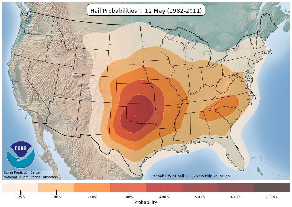
The normal hail probability for any May 12 is about one percent, so today’s probability is roughly five times normal.

There’s no reason to be alarmed by a marginal risk, but if you live in that half of Indiana, it’s wise to remain weather-aware today, especially if you’ll be involved in any outdoor activities (e.g. baseball games, etc.). Remember that all thunderstorms, severe or not, bring lightning, which kills people who are outdoors.

The SPC plans to update its outlook for today by 12:30 p.m. EDT.

Slight risk of severe storms in Southern Indiana Tues. May 10

National Weather Service Storm Prediction Center Day 2 Convective Outlook Mapy for Indiana issued May 9, 2016 shows a slight risk of severe storms in extreme southern Indiana between 8 a.m. EDT May 10 and 8 a.m. EDT May 11, 2016Extreme southern Indiana (shaded in yellow on the map above) has a slight risk of severe storms tomorrow, according to the “Day 2 Convective Outlook” that the National Weather Service Storm Prediction Center issued early this morning. The slight risk area includes Vincennes, Jasper, Corydon and Evansville, among other communities.

A slight risk on a day-two outlook means a 15 percent probability of any one or more of the following types of severe weather occurring within 25 miles of any point between 8 a.m. EDT tomorrow and 8 a.m. EDT Wednesday:

  • Tornado
  • Damaging straight-line severe thunderstorm winds of 58 mph or stronger.
  • Large hail of one inch or more in diameter.

The normal probability of one or more of the above on May 10 is approximately three percent, according to climatology data from the National Severe Storms Laboratory. That means tomorrow’s probabilities in the slight risk area of Indiana are approximately three times what’s normal on May 10.

The SPC plans to update its outlook for tomorrow by 1:30 p.m. EDT.