Tag Archives: #INwx

Severe weather is possible Sunday, Aug 6, including a tornado.

This map from today’s SPC Day 4 Severe Weather Outlook indicates an area (shaded in yellow) that has a 15% probability of severe weather on Sunday, August 6. It includes the entire state of Indiana.

TLDR: The National Weather Service Storm Prediction Center issued an outlook early this morning that indicates a probability of all forms of severe weather throughout Indiana Sunday, including tornadoes; damaging straight-line thunderstorm winds; and large hail. People should pay attention to reliable sources of weather information as Sunday nears, especially people who are planning outdoor activities Sunday afternoon and evening.

How we know this is possible

The Storm Prediction Center (SPC) is a branch of the U.S. National Weather Service (NWS) that’s responsible for providing timely and accurate forecasts and watches for severe thunderstorms and tornadoes over the contiguous United States. Every day, it issues severe weather outlooks for the current day (Day 1) and for days two (tomorrow), three, four, five, six, seven and eight.

Accurately predicting severe weather more than two days in advance is difficult. So, if the SPC indicates a possibility of severe weather in an outlook for three days from now, it’s wise to pay attention.

In the outlook for Sunday that SPC issued this morning (Aug. 3), it indicated a 15% probability of severe weather, including tornados, damaging straight-line thunderstorm winds and large hail, within 25 miles of any point in Indiana as well as parts of neighboring states.

Tornadoes, damaging straight-line winds and large hail are all possible in Indiana Sunday.

Why is 15% a big deal?

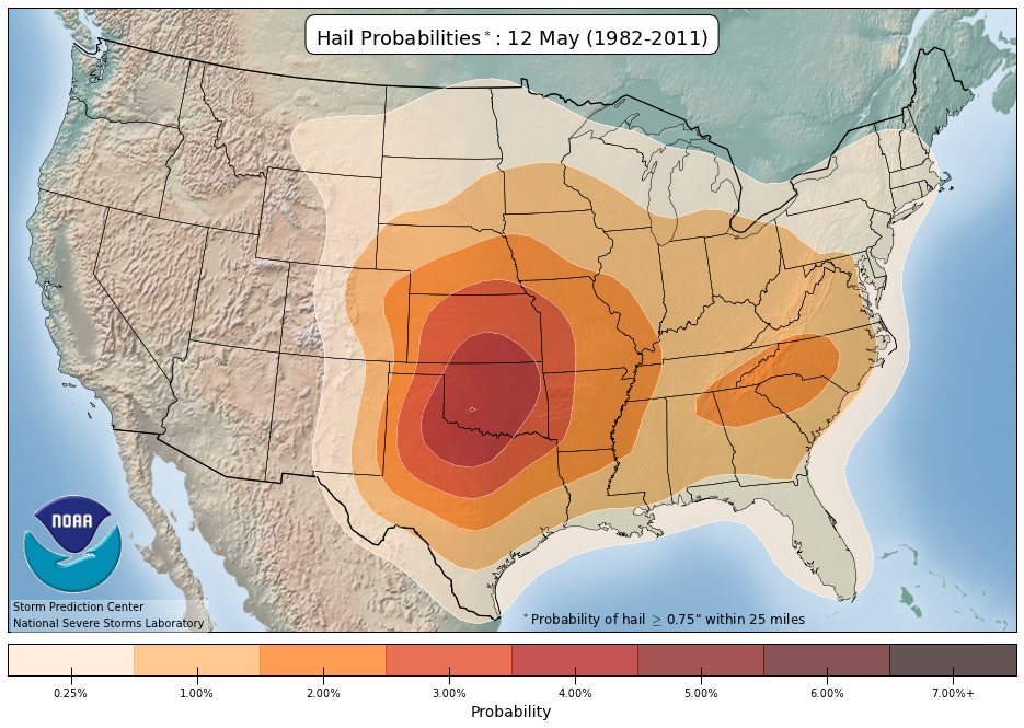
As percentages go, 15% looks pretty small. But that’s because severe storms don’t happen all the time. The SPC, in collaboration with another branch of the NWS, the NOAA National Severe Storms Laboratory (NSSL), analyzes historical weather data to determine the normal probability of severe weather on any given date (based on how many times it happened on that date in the past). That analysis indicates that in Indiana, the normal probability of severe weather on any August 6 is 2% to 3% (depending on where in the state, see graphic below).

SPC/NSSL map showing probabilities of severe weather in various parts of the continental United States on any August 6, based on data collected between 1982 and 2011.

That means Sunday’s 15% probability of severe storms is 5 to 7.5 times what’s normal for that date.

What’s most likely, tornadoes or severe thunderstorms?

Day 4 is too far away for SPC to provide probabilities for specific severe weather hazards, like tornados. Nonetheless, the text of today’s Day 4 outlook implies that tornadoes, damaging straight-line winds and large hail are all possible in Indiana Sunday.

In addition. local NWS offices in Indiana issued their own outlooks today that indicate the possibility of severe weather Sunday, especially in the afternoon and evening. These local outlooks also indicate the NWS might need reports from trained, volunteer storm spotters Sunday.

Tomorrow, SPC will issue a Day 3 outlook for Sunday that will provide a categorical risk level from one to five (five being the greatest risk) and possibly modify the target area based on the latest available weather data.

Saturday, SPC will issue a Day 2 outlook for Sunday that will provide individual probabilities of a tornado, damaging straight-line thunderstorm winds (58 mph or stronger), and large hail (one inch or larger). By then, we’ll have a much better idea of what parts of the state have the highest risk and which hazards are most likely.

What should you do now?

No matter who you are, if you’ll be in Indiana Sunday afternoon and evening, and especially if you plan to be involved in an outdoor activity, pay close attention to a trusted source of weather information as Sunday approaches, such as your local NWS office or professional broadcast meteorologists. If you don’t have a weather alert radio in your home, this would be a good time to buy one.

If you’re a trained Skywarn storm spotter like me, prepare for possible activation Sunday, including charging all your battery-powered devices and reviewing what to look for, what to report, and how to report it. The NWS will likely need your eyewitness reports so they can issue the best warnings and keep people safe.

Here’s why real meteorologists don’t yet know how bad the coming winter storm will be

A winter storm is coming to Indiana and will likely impact travel Thursday night and Friday, December 22 and 23.

Some areas could get a lot of snow. Some could get mostly rain.

As of this morning, the expert meteorologists at the National Weather Service’s Northern Indiana Office can’t forecast where the heaviest snow will fall.

The biggest reason is that meteorological science isn’t capable yet of forecasting the exact track of a low pressure system four days in advance.

I’m not a meteorologist, but I’ve spent enough time collaborating with meteorologists to develop a fair understanding of their work. So, I’ll try to explain here what I know about the coming storm, based on what the pros have published.

First, it helps to know how low pressure systems affect winter weather. Typically, the heaviest snow falls to the north and northwest of a low pressure system. Areas to the east and northeast usually get mostly rain. Areas to the southeast can get clear skies with little or no precipitation.

The path a low pressure system takes therefore has a major impact on where the biggest winter storm impacts will occur.

The main way meteorologists predict a system’s path is by monitoring the output of special computer programs known as numerical weather prediction models. These programs run on supercomputers, because they ingest massive amounts of weather observation data and apply complex equations in their attempts to create reliable, mathematical simulations of the atmosphere. Several such programs exist, all written differently. It’s not unusual for the various models to produce different solutions, which typically come out every 12 hours.

Meteorologist Megan Dodson at the Northern Indiana NWS office wrote in an Area Forecast Discussion this morning that they’re watching the outputs of at least four different models. They’re paying attention to how much consensus exists between the solutions of the various models and how consistent each model’s output is with previous output from the same model.

As of this morning’s forecast discussion, these models indicated that the low pressure system would move from the southwest to the northeast and that the path it follows would be farther west than previous model runs indicated. The image below, published by the Indianapolis NWS office, shows three possible paths for the system. One model, known as the Global Forecast System (GFS), is an outlier, forecasting the most westward path. If it’s right, and the center of the low stays west of Indiana, the Hoosier state won’t get much snow. Other models forecast more easterly paths.

Graphic published by NWS Indianaolis showing possible tracks of a low pressure system associated with a forecast winter storm

All the models could still be wrong!

Numerical weather prediction is not perfect, but the closer the low pressure system gets to Indiana, the more the models will align and the better the forecasts will get.

As I write this, the system is still over the Pacific Ocean, so it should be understandable that it’s too early for the models to accurately predict how it will track over the Midwest.

For now, it’s important to understand that a winter storm will very likely occur somewhere, but as much as you’d like to know exactly where the most snow will fall (and where the most travel impacts will be), it’s just too early to know.

That said, because it’s also too early to rule out big impacts in any part of northern Indiana, it’s wise to prepare for such impacts. For example, you might shop for Christmas dinner ingredients a day earlier than you originally planned, just in case.

It’s also important to realize that some people who are not meteorologists post official-looking but unscientific forecasts on social media. Often, they choose the single model output that looks the most dramatic (even though it’s an outlier), rather than create legitimate forecasts based on a full understanding of model limitations and model consensus. Often, the main goal of such posts is to create bigger audiences for advertisements. Keep that in mind the next time you see a dramatic snow forecast for any time that’s more than a few days away.

High probability of very severe weather in Indiana today

Probabilities of damaging, straight-line winds or gusts.

Damaging, straight-line thunderstorm winds — the kind that can knock down whole trees and cause widespread power outages and road blockages — are likely in Indiana this afternoon and evening, especially in extreme southwestern counties (shaded purple in the map above), according to a convective outlook that the National Weather Service (NWS) Storm Prediction Center issued at 9 a.m. ET today.

The 45% probability indicated on the map above compares to “normal” or “average” probability for this time of year of only 1%, acccording to climatology (weather history) data from the National Severe Storms Laboratory.

And in a large part of southern Indiana (shaded gray on the map below), any severe thundertorms that form could create wind gusts of 75 mph or stronger. That’s the same as a category one hurricane. The probability of that happening is 10 percent, or approximately 100 times the climatology norm of 0.1%

Probability of gusts of 75 mph or stronger.

Tornadoes are also possible throughout Indiana and once again, the greatest risk is in the southwest (shaded yellow on the map below), where the probability is 10%, or about 25 times the climatology norm. The 5% probability in the rest of the state is about 12.5 times the norm for this time of year. So even though 10 and five are small numbers, they’re important in this context.

Probability of a tornado.

Any tornadoes that form in southwestern Indiana (shaded gray on the map below) have a 10% probability of doing damage rated EF-2 or higher on the enhanced Fujitsu scale. That’s about 50 times the climatology norm.

Probability of a significant tornado doing damange of EF-2 or greater.

The entire state also has a risk of one-inch or larger hail, but as the map below indicates, the hail risk is lower than the straight-line wind risk.

Probability of one-inch or larger hail.

It’s important for anyone in Indiana to have multiple ways to receive severe thunderstorm and tornado warnings today. Unfortunately, the Indianapolis NWS office reported this morning that three NOAA Weather Radio transmitters in southern Indiana were inoperative.

NWS Indianapolis tweet about inopertive weather radio transmitters

Update: The Indianapolis NWS office reported at 11:44 a.m. ET that all three transmitters had returned to service.

That makes multiple alerting methods even more important. People in that area shold probably keep a TV on, turned up, and tuned to a local station (i.e., not ESPN or Netflix!). Another idea is to install the free FEMA app on smartphones.

If your phone and other rechargeable devices are not fully charged, start charging them now.

If you’re a volunteer Skywarn storm spotter, prepare for activation this afternoon or evening.

Half of Indiana has marginal risk of severe storms today

Indiana map showing (Left) Risk of severe weather between 9 a.m. EDT today and 8 a.m. EDT tomorrow. Dark green shading: Marginal risk. Light green: thunderstorms possible but none expected to be severe. (Center) Probability of damaging straight-line thunderstorm winds of 58 mph or stronger within 25 miles of any point. Brown: 5% (marginal risk). Unshaded: Less than 5%. (Right) Probability of hail of one inch diameter or larger within 25 miles of any point. Brown: 5% (marginal risk). Unshaded: Less than 5%. Source: SPC "Day 1 Convective Outlook" issued at 8:52 a.m. EDT.
(Left) Risk of severe weather between 9 a.m. EDT today and 8 a.m. EDT tomorrow. Dark green shading: Marginal risk. Light green: thunderstorms possible but none expected to be severe. (Center) Probability of damaging straight-line thunderstorm winds of 58 mph or stronger within 25 miles of any point. Brown: 5% (marginal risk). Unshaded: Less than 5%. (Right) Probability of hail of one inch or more in diameter within 25 miles of any point. Brown: 5% (marginal risk). Unshaded: Less than 5%. Source: SPC “Day 1 Convective Outlook” issued at 8:52 a.m. EDT. Click the image for a larger version.

Half of Indiana (shaded in dark green on the map, above-left) has a marginal risk of severe thunderstorms between 9 a.m. EDT today and 8 a.m. EDT tomorrow, according to the “Day 1 Convective Outlook” that the National Weather Service Storm Prediction Center (SPC) issued at 8:52 a.m.

The primary risks are damaging straight-line thunderstorm winds of 58 mph or stronger and hail of one inch or more in diameter. The probability of either occurring within 25 miles of any point in the slight risk area is five percent.

The normal wind probability for any May 12 is about two percent, according to climatology data from the National Severe Storms Laboratory. Today’s probability, therefore, is roughly twice the normal probability for this date.

The normal hail probability for any May 12 is about one percent, so today’s probability is roughly five times normal.

There’s no reason to be alarmed by a marginal risk, but if you live in that half of Indiana, it’s wise to remain weather-aware today, especially if you’ll be involved in any outdoor activities (e.g. baseball games, etc.). Remember that all thunderstorms, severe or not, bring lightning, which kills people who are outdoors.

The SPC plans to update its outlook for today by 12:30 p.m. EDT.

Slight risk of severe storms in Southern Indiana Tues. May 10

National Weather Service Storm Prediction Center Day 2 Convective Outlook Mapy for Indiana issued May 9, 2016 shows a slight risk of severe storms in extreme southern Indiana between 8 a.m. EDT May 10 and 8 a.m. EDT May 11, 2016Extreme southern Indiana (shaded in yellow on the map above) has a slight risk of severe storms tomorrow, according to the “Day 2 Convective Outlook” that the National Weather Service Storm Prediction Center issued early this morning. The slight risk area includes Vincennes, Jasper, Corydon and Evansville, among other communities.

A slight risk on a day-two outlook means a 15 percent probability of any one or more of the following types of severe weather occurring within 25 miles of any point between 8 a.m. EDT tomorrow and 8 a.m. EDT Wednesday:

  • Tornado
  • Damaging straight-line severe thunderstorm winds of 58 mph or stronger.
  • Large hail of one inch or more in diameter.

The normal probability of one or more of the above on May 10 is approximately three percent, according to climatology data from the National Severe Storms Laboratory. That means tomorrow’s probabilities in the slight risk area of Indiana are approximately three times what’s normal on May 10.

The SPC plans to update its outlook for tomorrow by 1:30 p.m. EDT.

Know anyone who’s still confused by watch vs. warning?

Wizard of Oz witch tornado watch warning meme
Meme creator unknown

The U.S. National Weather Service has been issuing tornado and severe thunderstorm watches and warnings since 1965. More than 50 years later, however, people still fail to fully understand the difference between a watch and a warning. You probably know some of them, I certainly do.

As my contribution to the second day of Indiana’s Severe Weather Preparedness Week 2016, I’ve written this blog to share with your friends and family members who remain confused.

A watch is essentially a forecast

Map showing tornado watch for a large part of Indiana and Michigan for 11:20 a.m. to 8 p.m. Nov. 17, 2013.

In fact, before 1965, the NWS called what we now know as “tornado watches” “tornado forecasts.” A tornado watch indicates the possibility of tornadoes forming, just as a rain forecast indicates the probability of rain. Similarly, a severe thunderstorm watch indicates the possibility of severe thunderstorms forming. A watch does not mean these things are already happening, it means they could happen.

Like a forecast, a watch covers a period of many hours and usually covers a large area of at least several counties, if not several states. We should watch for possible dangerous weather in the near future.

A warning is an indication of immediate danger

Polygon indicating the area covered by a tornado warning for the Kokomo, Indiana area Nov. 17, 2013.
Polygon indicating the area covered by a tornado warning for the Kokomo, Indiana area from 3:17 p.m. to 3:45 p.m. Nov. 17, 2013. Click the image to see a larger version.

It’s a call to take shelter now, because the tornado or severe thunderstorm is already happening. Depending on where you are, you might only have couple of minutes to protect yourself and your family. Or, you might have 10 or 15 minutes, if you’re at the far edge of the “warning polygon.” If you want to survive a tornado or a severe thunderstorm, don’t waste time seeking more information. When a warning comes out, take shelter immediately.

Because dangerous weather has already formed and is on its way, a warning usually covers a period of less than an hour and a small area that’s sometimes smaller than a county. The time to watch is over. It’s now time to heed the warning and take shelter.

Want even more lead time?

If you’re really interested in weather, or want to know even earlier whether severe weather is possible, there are two other NWS products to check out.

The NWS Storm Prediction Center (SPC) usually issues a “mesoscale discussion” before it issues a watch. This product lets you know that the SPC is thinking about (or planning to) issue a watch, the geographical area of concern and the reasons. Some of the text of a mesoscale discussion can get pretty technical, but anyone can figure out from this product whether a watch is likely to be issued. If any mesoscale discussions are in effect, you can find them on the SPC website.

For even more lead time, the SPC issues “convective outlooks” that indicate the amount of risk of severe weather as much as eight days in advance. You can also find these products on the SPC website.

NWS northern Indiana issues severe weather preparedness week news release

National Weather Service Press Release
FOR IMMEDIATE RELEASE March 14, 2016

INDIANA SEVERE WEATHER PREPAREDNESS WEEK, MARCH 20-26

******** STATEWIDE TORNADO DRILLS MARCH 22nd ********

Syracuse, IN – So far, 2016 severe weather does not compare with the tragic March 2012 tornadoes to strike southern Indiana.  Is that a sign for fewer tornadoes this year? “Indiana has tornadoes every year,” said Michael Lewis, Warning Coordination Meteorologist with the National Weather Service in Northern Indiana.  “But events like the deadly tornado of March 2012 point to the importance of being ready and responsive in the face of increasing hazardous weather events. Being resilient is part of the vision of the National Weather Service (NWS) as we grow toward becoming a Weather Ready Nation,” added Lewis.

The National Weather Service, in cooperation with the Indiana State Department of Homeland Security, Indiana State Police, Indiana Department of Education, the Indiana Broadcasters Association, the American Red Cross, and the amateur radio community, will conduct a Severe Weather Preparedness campaign March 20-26, 2016.

The 38th annual statewide test tornado drills will be conducted on Tuesday March 22 at 10:15 am and 7:35 pm EDT.  Wednesday March 23 is the make-up drill day if severe weather postpones Tuesday’s drill.   The drill will be initiated by TEST Tornado Warnings issued by NWS offices serving Indiana, triggering programmed electronic devices and activation of many outdoor warning sirens.

“Every family, every school, and every business should take time now to review or create a weather safety action plan,” said John Erickson, Public Information Officer of the Indiana Department of Homeland Security. “Having and practicing a plan increases your chances of surviving the storm,” added Erickson.

For further information, you may refer to: www.weather.gov/ind also:

http://www.nws.noaa.gov/com/weatherreadynation/  #SpringSafety

####

Where thunderstorms go to die

SKYWARN storm spotters and future spotters prepare for training Feb. 16, 2016 at the Public Safety Academy of Northeast Indiana, Fort Wayne

The husband-and-wife team of Amos and Megan Dodson, both meteorologists at the northern Indiana office of the National Weather Service (NWS), conducted the annual SKYWARN storm spotter training Feb. 16 at the Public Safety Academy of Northeast Indiana.

The content of the training didn’t change much from last year’s presentation. It focused on the differences between truly threatening weather phenomena and scary-looking, but harmless (and unreportable) conditions.

Here are some highlights:

  • Spotter reports add credibility. When the NWS issues a warning that includes a reference to a spotter report, members of the general public are more likely to take action than when the warning does not include a spotter reference.
  • Don’t wait for activation. Although our NWS office issues hazardous weather outlooks that indicate whether spotter activation is likely, the office does not “activate” or “deploy” spotters. It welcomes spotters to make reports anytime they see anything reportable.
  • Clouds with ragged edges aren’t spinning. Scary-looking SCUD clouds that are shaped like funnel clouds generate a lot of well-intended but false reports from untrained observers. True funnel clouds and tornadoes spin, giving them sharper, smoother edges.
  • When unsure, send a photo. NWS encourages spotters who see something that might be reportable (like a possible wall cloud or funnel cloud), to photograph it and send the photo via Twitter (@NWSIWX) or the NWS office’s Facebook page. The office monitors both social networks closely during severe weather events.
  • T.E.L. NWS. When spotters make reports, they should provide the Time of the observation, a description of the Event, and the Location of the event. The actual time of day is more valuable than “right now” or “two minutes ago.” And because the local NWS office does not issue spotter credentials, formatting reports in that specific order is one way spotters can demonstrate they attended the training.
  • Thunderstorms come here to die! Spotters provide a valuable service to their communities even if they don’t see anything reportable. And climatology data shows that spotters in Indiana are about half as likely to see something as are spotters in Illinois. Megan Dodson shared that this leads meteorologists to joke that Indiana is where thunderstorms come to die.

Mysteriously, far fewer people attended the training than registered for it, even though weather did not hinder travel that night. Those in attendance, however, included TV meteorologist Hannah Strong, who indicated that the presentation included information not provided in meteorology school.

People who missed the training can get via the Web most of the information they need to be effective spotters. Two options include

Updated: Seminars offer deeper dive for SKYWARN storm spotters

Seminars around Indiana provide opporutnities for advanced training for SKYWARN storm spottersJan. 5, I wrote about annual SKYWARN storm spotter training beginning in less than a month in some parts of Indiana. Today, I’d like to share other educational opportunities for spotters and others who’d like to take a deeper dive into severe weather meteorology.

Central Indiana Severe Weather Symposium, Indianapolis

2016 Central Indiana Severe Weather Symposium logoThis day-long event, hosted by the central Indiana chapter of the American Meteorology Society and the National Weather Service Indianapolis weather forecast office, always provides lots of fascinating information of value to storm spotters. If you want to attend, register early, because it often “sells out” well before the day of the event.

Saturday, March 5, 2016, 8 a.m. to 4 p.m., Reilly Room, Atherton Union, Butler University, 704 West Hampton Drive. Information and registration: http://www.weather.gov/ind/2016CISWS. Twitter tweets about this event carry the hash tag #CISWS.

DuPage County Advanced Severe Weather Seminar, Wheaton, Ill.

2016 DuPage County Advanced Severe Weather Seminar infographicThis all-day event in one of is one of the best advanced spotter training opportunities in the Midwest. I’ve attended at least twice. It’s in a western suburb of Chicago, so it’s a bit of a drive for many Hoosiers! DuPage College’s meteorology professors usually speak and they’re both great presenters.

Saturday, March 12, 2016, Wheaton College. Information and registration are now available at https://www.dupageco.org/weatherseminar/. See also: #DuPageWxSeminar and https://www.facebook.com/groups/dupagesevereweather/.

Ohio State Meteorology Club Severe Weather Symposium, Columbus, Ohio

I’ve attended at least three of these annual, all-day events. They usually contain interesting information and speakers but they are geared more toward meteorology students than to spotters.

Friday, March 4, 2016, Ohio State University, Columbus, Ohio. Information and registration are now available at http://u.osu.edu/metclub/symposium/2016-symposium/.

Severe Weather Awareness Day, Nashville, Tenn.

This annual event might be of interest to storm spotters who live in southern Indiana and points south. I’ve never attended, but a friend has been impressed with it. As you can see in the flyer image above, one of this year’s speakers is well-known broadcast meteorologist James Spann.

Saturday, Feb. 27, Trevecca Nazarene University, Nashville, Tenn. Information (with registration beginning Feb. 1) at http://www.srh.noaa.gov/ohx/?n=swad2016. See also  https://twitter.com/hashtag/swad2016?f=tweets&vertical=default.

Others?

If you know of other good, advanced training opportunities for storm spotters, leave a note in the comments section of this blog post.

NWS plans Twitter commemoration of Palm Sunday tornado outbreak

The famous Palm Sunday twin tornado photo, taken along U.S. 33 by Paul Huffman of the
The famous Palm Sunday twin tornado photo, taken along U.S. 33 by Paul Huffman of the “Elkhart Truth”

If you follow the the northern Indiana office of the National Weather Service on Twitter (@NWSIWX) and if your smart phone beeps at you every time the office tweets, you might want to change your settings before tomorrow.

The office plans to send more than 100 tweets to mark the 50th anniversary of the April 11, 1965 Palm Sunday tornado outbreak that killed 145 people in Indiana. No other tornado outbreak in the state’s history has killed that many people.

Presentation slide from northern Indiana NWS office.

The NWS office plans to send tweets in real time, as if it were live tweeting during the actual outbreak. Every tweet will include the hash tag #PalmSunday50. This will give followers a feel for how NWS received information that day and the warnings it issued.

You can follow along, whether or not you have a Twitter account. The tweets will be visible at either of the following Web URLs:

https://twitter.com/search?f=realtime&q=%22%23PalmSunday50%22&src=typd

https://twitter.com/nwsiwx

The NWS office has also created a special website that provides detailed information about the outbreak, including photos like the one at the top of this post and first-hand accounts that witnesses provided the NWS.