
Line of storms on its way


URGENT - WEATHER MESSAGE
NATIONAL WEATHER SERVICE NORTHERN INDIANA
514 PM EST THU FEB 20 2014

...WIDESPREAD DENSE FOG FOLLOWED BY STRONG WINDS...

.WARM MOIST AIR MOVING OVER THE SNOW COVERED GROUND WAS CAUSING
WIDESPREAD DENSE FOG FROM GAS CITY TO WABASH TO LAPORTE THIS
EVENING. THE DENSE FOG WILL LIFT NORTH ALONG A WARM FRONT EARLY
THIS EVENING... MOVING INTO THE SOUTH BEND AND FORT WAYNE AREAS. A
COLD FRONT WILL SURGE EASTWARD ACROSS OUR AREA LATER THIS EVENING
WITH A PERIOD OF STRONG SOUTHWEST WINDS OF 30 MPH WITH GUSTS TO 45
MPH. ADDITIONAL STRONG SOUTHWEST WINDS ARE EXPECTED TO REDEVELOP
FRIDAY MORNING AND CONTINUE THROUGH FRIDAY AFTERNOON.

INZ003-004-012>018-020-022>027-032>034-210615-
/O.NEW.KIWX.FG.Y.0003.140220T2214Z-140221T0100Z/
/O.CON.KIWX.WI.Y.0001.140221T0000Z-140221T2300Z/
LA PORTE-ST. JOSEPH IN-STARKE-PULASKI-MARSHALL-FULTON IN-
KOSCIUSKO-WHITLEY-ALLEN IN-WHITE-CASS IN-MIAMI-WABASH-HUNTINGTON-
WELLS-ADAMS-GRANT-BLACKFORD-JAY-
INCLUDING THE CITIES OF...MICHIGAN CITY...LA PORTE...SOUTH BEND...
MISHAWAKA...NEW CARLISLE...WALKERTON...KNOX...NORTH JUDSON...
BASS LAKE...WINAMAC...FRANCESVILLE...MEDARYVILLE...PLYMOUTH...
BREMEN...CULVER...ROCHESTER...AKRON...WARSAW...WINONA LAKE...
SYRACUSE...MENTONE...COLUMBIA CITY...TRI-LAKES...SOUTH WHITLEY...
FORT WAYNE...NEW HAVEN...MONTICELLO...BROOKSTON...MONON...
LOGANSPORT...ROYAL CENTER...PERU...GRISSOM AFB...MEXICO...
WABASH...NORTH MANCHESTER...HUNTINGTON...ROANOKE...BLUFFTON...
OSSIAN...DECATUR...BERNE...MARION...GAS CITY...UPLAND...
HARTFORD CITY...MONTPELIER...PORTLAND...DUNKIRK
514 PM EST THU FEB 20 2014 /414 PM CST THU FEB 20 2014/

...DENSE FOG ADVISORY IN EFFECT UNTIL 8 PM EST /7 PM CST/ THIS
EVENING...
...WIND ADVISORY REMAINS IN EFFECT UNTIL 6 PM EST /5 PM CST/
FRIDAY...

THE NATIONAL WEATHER SERVICE IN NORTHERN INDIANA HAS ISSUED A
DENSE FOG ADVISORY...WHICH IS IN EFFECT UNTIL 8 PM EST /7 PM CST/
THIS EVENING.

 * WIDESPREAD DENSE FOG EARLY THIS EVENING.

 * WINDS...SOUTHWEST 30 MPH WITH GUSTS TO 45 MPH LATER THIS EVENING.

 * IMPACTS...TRAVEL ON WEST-EAST ORIENTED ROADS WILL BE
   DIFFICULT AT TIMES ESPECIALLY IN HIGH PROFILE VEHICLES.

PRECAUTIONARY/PREPAREDNESS ACTIONS...

A WIND ADVISORY MEANS THAT SUSTAINED WINDS OF 30 MPH...OR GUSTS
OVER 45 MPH ARE EXPECTED. WINDS THIS STRONG CAN MAKE DRIVING
DIFFICULT...ESPECIALLY FOR HIGH PROFILE VEHICLES. USE EXTRA
CAUTION.

A DENSE FOG ADVISORY MEANS VISIBILITIES WILL FREQUENTLY BE
REDUCED TO LESS THAN ONE QUARTER MILE. IF DRIVING...SLOW DOWN...
USE YOUR HEADLIGHTS...AND LEAVE PLENTY OF DISTANCE AHEAD OF YOU.

February 20, 2014 (noon) – Public Works and Utility staff are addressing a few street flooding issues that occurred due to this morning’s heavy rain. River levels remain low today but because some storm drains are blocked by ice and debris there is higher water in some streets across the City. Residents are asked to check inlets in their neighborhoods and remove obstructions that might be blocking the flow of melted snow and rainwater from getting into the storm sewers. The City has more than 90,000 storm inlets.
Motorists should not attempt to drive through standing water in roadways.
Residents should call 311 to report high water. If it’s after hours, residents should remain on the line and the automated prompts will help them reach the sewer maintenance department.
The Public Works Division is making additional sites available where residents can fill sandbags to protect their property.
Residents will need to bring their own shovels to fill the bags. Sand will be available by 3:00 p.m. today at the following locations:
Northside Park – parking lot, Parnell Avenue
Ash Centre – parking lot, 1701 Freeman Street
Seriously… pic.twitter.com/zhGuTaFYDA
— B. (@breekahkola) February 20, 2014
@carstonldick007 yah..maintenance Said there is 6-8 inches of just water against the wall that’s coming in
— B. (@breekahkola) February 20, 2014
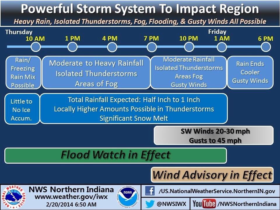
FLOOD WATCH
NATIONAL WEATHER SERVICE NORTHERN INDIANA
1133 AM EST THU FEB 20 2014

...FLOODING POTENTIAL TODAY AND TONIGHT...

.RAIN TODAY COMBINED WITH MELTING SNOW WILL BRING A RISK FOR
FLOODING TO THE AREA THROUGH TONIGHT. LONGER DURATION RIVER
FLOODING WILL ALSO BE POSSIBLE INTO THIS WEEKEND. PEOPLE LIVING IN
AREAS PRONE TO FLOODING SHOULD TAKE TIME TO PREPARE NOW AND LISTEN
FOR POSSIBLE WARNINGS.

SNOW AND ICE CURRENTLY ON THE GROUND CONTAINS A LARGE QUANTITY OF
STORED WATER...GENERALLY 1.0 TO 3.5 INCHES ACROSS THE REGION. THE
GREATEST WATER CONTENT IS ACROSS PORTIONS OF NORTHERN INDIANA AND
SOUTHERN LOWER MICHIGAN. THE COMBINATION OF WARMER TEMPERATURES
THIS AFTERNOON INTO THIS EVENING ALONG WITH MODERATE TO HEAVY
RAINFALL EARLIER THIS MORNING WILL RESULT IN INCREASED RUNOFF.

WATER RUNOFF FROM THE COMBINED RAINFALL AND SNOW MELT OVER A
DEEPLY FROZEN GROUND WILL LEAD TO A HEIGHTENED POTENTIAL FOR
FLOODING IN LOW LYING AREAS...BASEMENTS...SMALL CREEKS AND
STREAMS. SIGNIFICANT RISES ALONG MAIN STEM RIVERS WILL LIKELY
FOLLOW INTO THIS WEEKEND.

MANY STREAMS AND RIVERS ARE ALSO COVERED IN THICK ICE WHICH MAY
BREAKUP AND INCREASE THE RISK FOR ICE JAMS AND RAPIDLY RISING
WATER. THIS WOULD SIGNIFICANTLY INCREASE LOCAL FLOODING POTENTIAL
NEAR THESE BODIES OF WATER.

STAY ALERT FOR POSSIBLE WARNINGS BY VISITING WEATHER.GOV/IWX OR
LISTENING TO LOCAL MEDIA BROADCASTS.

INZ003>009-012>018-020-022>027-032>034-MIZ077>081-OHZ001-002-004-
005-015-016-024-025-210045-
/O.CON.KIWX.FA.A.0001.000000T0000Z-140221T0600Z/
/00000.0.RS.000000T0000Z.000000T0000Z.000000T0000Z.OO/
LA PORTE-ST. JOSEPH IN-ELKHART-LAGRANGE-STEUBEN-NOBLE-DE KALB-
STARKE-PULASKI-MARSHALL-FULTON IN-KOSCIUSKO-WHITLEY-ALLEN IN-
WHITE-CASS IN-MIAMI-WABASH-HUNTINGTON-WELLS-ADAMS-GRANT-BLACKFORD-
JAY-BERRIEN-CASS MI-ST. JOSEPH MI-BRANCH-HILLSDALE-WILLIAMS-
FULTON OH-DEFIANCE-HENRY-PAULDING-PUTNAM-VAN WERT-ALLEN OH-
INCLUDING THE CITIES OF...MICHIGAN CITY...LA PORTE...SOUTH BEND...
MISHAWAKA...NEW CARLISLE...WALKERTON...ELKHART...GOSHEN...
NAPPANEE...LAGRANGE...TOPEKA...SHIPSHEWANA...ANGOLA...FREMONT...
KENDALLVILLE...LIGONIER...ALBION...AUBURN...GARRETT...KNOX...
NORTH JUDSON...BASS LAKE...WINAMAC...FRANCESVILLE...MEDARYVILLE...
PLYMOUTH...BREMEN...CULVER...ROCHESTER...AKRON...WARSAW...
WINONA LAKE...SYRACUSE...MENTONE...COLUMBIA CITY...TRI-LAKES...
SOUTH WHITLEY...FORT WAYNE...NEW HAVEN...MONTICELLO...BROOKSTON...
MONON...LOGANSPORT...ROYAL CENTER...PERU...GRISSOM AFB...MEXICO...
WABASH...NORTH MANCHESTER...HUNTINGTON...ROANOKE...BLUFFTON...
OSSIAN...DECATUR...BERNE...MARION...GAS CITY...UPLAND...
HARTFORD CITY...MONTPELIER...PORTLAND...DUNKIRK...NILES...
BENTON HARBOR...ST. JOSEPH...BUCHANAN...DOWAGIAC...CASSOPOLIS...
MARCELLUS...STURGIS...THREE RIVERS...WHITE PIGEON...MENDON...
COLDWATER...BRONSON...HILLSDALE...LITCHFIELD...JONESVILLE...
BRYAN...WAUSEON...ARCHBOLD...FAYETTE...SWANTON...DEFIANCE...
SHERWOOD...HICKSVILLE...NAPOLEON...DESHLER...LIBERTY CENTER...
PAULDING...ANTWERP...MELROSE...OTTAWA...PANDORA...KALIDA...
FORT JENNINGS...VAN WERT...DELPHOS...OHIO CITY...LIMA...
SPENCERVILLE
1133 AM EST THU FEB 20 2014 /1033 AM CST THU FEB 20 2014/

...FLOOD WATCH REMAINS IN EFFECT THROUGH LATE TONIGHT...

THE FLOOD WATCH CONTINUES FOR

* PORTIONS OF NORTHERN INDIANA...SOUTHWEST MICHIGAN AND
  NORTHWEST OHIO...INCLUDING THE FOLLOWING AREAS...IN NORTHERN
  INDIANA...ADAMS...ALLEN IN...BLACKFORD...CASS IN...DE KALB...
  ELKHART...FULTON IN...GRANT...HUNTINGTON...JAY...KOSCIUSKO...
  LA PORTE...LAGRANGE...MARSHALL...MIAMI...NOBLE...PULASKI...ST.
  JOSEPH IN...STARKE...STEUBEN...WABASH...WELLS...WHITE AND
  WHITLEY. IN SOUTHWEST MICHIGAN...BERRIEN...BRANCH...CASS MI...
  HILLSDALE AND ST. JOSEPH MI. IN NORTHWEST OHIO...ALLEN OH...
  DEFIANCE...FULTON OH...HENRY...PAULDING...PUTNAM...VAN WERT
  AND WILLIAMS.

* THROUGH LATE TONIGHT

* A COMBINATION OF MELTING SNOW...RUNOFF FROM MODERATE TO LOCALLY
  HEAVY RAINFALL...AND A DEEPLY FROZEN GROUND WILL LIKELY LEAD TO
  FLOODING THROUGH TONIGHT.

* RAINFALL AMOUNTS OF 0.50 TO 1.25 INCHES HAVE BEEN REPORTED
  ACROSS PORTIONS OF NORTHERN INDIANA...SOUTHERN LOWER
  MICHIGAN...AND FAR NORTHWEST OHIO THIS MORNING. AN ADDITIONAL
  0.25 TO 0.50 INCHES OF RAINFALL IS POSSIBLE THROUGH TONIGHT WITH
  LOCALLY HIGHER AMOUNTS POSSIBLE. ONE TO TWO INCHES OF WATER
  COULD BE RELEASED FROM THE SNOW ON THE GROUND AS IT MELTS.

PRECAUTIONARY/PREPAREDNESS ACTIONS...

A FLOOD WATCH MEANS THERE IS A POTENTIAL FOR FLOODING BASED ON
CURRENT FORECASTS.

YOU SHOULD MONITOR LATER FORECASTS AND BE ALERT FOR POSSIBLE
FLOOD WARNINGS. THOSE LIVING IN AREAS PRONE TO FLOODING SHOULD BE
PREPARED TO TAKE ACTION SHOULD FLOODING DEVELOP.
Thru 10 am, over half an inch in Fort Wayne and very close to an inch of rain has fallen at South Bend and @NWSIWX
— NWS Northern Indiana (@NWSIWX) February 20, 2014

A combination of melting snow and moderate to locally heavy rainfall has Allen County officials warning residents to take action now against possible flooding in the area.
The flooding threat has led the Allen County Highway Department to offer citizens free sandbags.
The fill-them-yourself bags and sand will be available anytime until further notice inside the salt storage units at the highway department’s two maintenance facilities. The north facility is located at 2234 Carroll Road and the south facility is located at 8317 East Tillman Road. Sandbags are available on a first-come basis and you will need to bring your own shovel.
 |
| Probabilities of a tornado within 25 miles of a point. Green area: 2%. Brown area: 5%. |
 |
| Probabilities of damaging thunderstorm winds or wind gusts of 50 knots (58 mph) or higher within 25 miles of a point. Pink area: 45%. Red area: 30%. Yellow area: 15%. Brown area: 5%. Hatched Area: 10% or greater probability of wind gusts of 65 knots (75 mph) or greater within 25 miles of a point. Read more about probabilities. |
The risk of severe thunderstorms in most of northern Indiana remains below the “slight” category between 7 a.m. EST today and 7 a.m. EST tomorrow, according to a Day 1 Convective Outlook that the National Weather Service (NWS) Storm Prediction Center (SPC) issued at 5:13 a.m. EST.
The southern half of Indiana, however, has a slight risk of severe weather during that period, including a two percent to five percent probability of a tornado and a 15 percent to 30 percent probability of damaging thunderstorm winds or wind gusts of 50 knots (58 mph) or higher within 25 miles of a point.
Northern Indiana, including the 37 counties covered by the northern Indiana NWS office, has a five percent probability of damaging thunderstorm winds or wind gusts of 50 knots (58 mph) or higher within 25 miles of a point (see maps at right).
According to a Hazardous Weather Outlook that the northern Indiana NWS office issued at 4:20 a.m. EST, flooding and strong winds are possible today. A flood watch remains in effect because locally heavy rain and melting snow might lead to excessive runoff into low-lying areas, streams and creeks. Read the latest flood watch statement.
After a strong cold front moves through this afternoon or evening, NWS expects a period of strong, southwesterly winds of 30 mph with gusts to 45 mph. That’s why the office issued a Wind Advisory at 3:13 a.m. EST. Read the complete Wind Advisory.
Although the northern Indiana NWS office does not expect that today’s weather will require activation of SKYWARN spotters, the office wrote in its Hazardous Weather Outlook that it will appreciate any reports of flooding. If you’re a spotter, you can make such reports via telephone (to the unlisted spotter number), Twitter (@NWSIWX) or on the office’s Facebook page.
Prepare for possible flooding now: If your basement is prone to flooding, make sure everything is elevated off of the floors.
— NWS Northern Indiana (@NWSIWX) February 20, 2014
If there are snow piles covering the storm drains in your neighborhood, shovel them out, so the water doesn’t back up in streets
— NWS Northern Indiana (@NWSIWX) February 20, 2014