
 |
| Probabilities of a tornado within 25 miles of a point. Green area: 2%. Brown area: 5%. |
 |
| Probabilities of damaging thunderstorm winds or wind gusts of 50 knots (58 mph) or higher within 25 miles of a point. Pink area: 45%. Red area: 30%. Yellow area: 15%. Brown area: 5%. Hatched Area: 10% or greater probability of wind gusts of 65 knots (75 mph) or greater within 25 miles of a point. Read more about probabilities. |
The risk of severe thunderstorms in most of northern Indiana remains below the “slight” category between 7 a.m. EST today and 7 a.m. EST tomorrow, according to a Day 1 Convective Outlook that the National Weather Service (NWS) Storm Prediction Center (SPC) issued at 5:13 a.m. EST.
The southern half of Indiana, however, has a slight risk of severe weather during that period, including a two percent to five percent probability of a tornado and a 15 percent to 30 percent probability of damaging thunderstorm winds or wind gusts of 50 knots (58 mph) or higher within 25 miles of a point.
Northern Indiana, including the 37 counties covered by the northern Indiana NWS office, has a five percent probability of damaging thunderstorm winds or wind gusts of 50 knots (58 mph) or higher within 25 miles of a point (see maps at right).
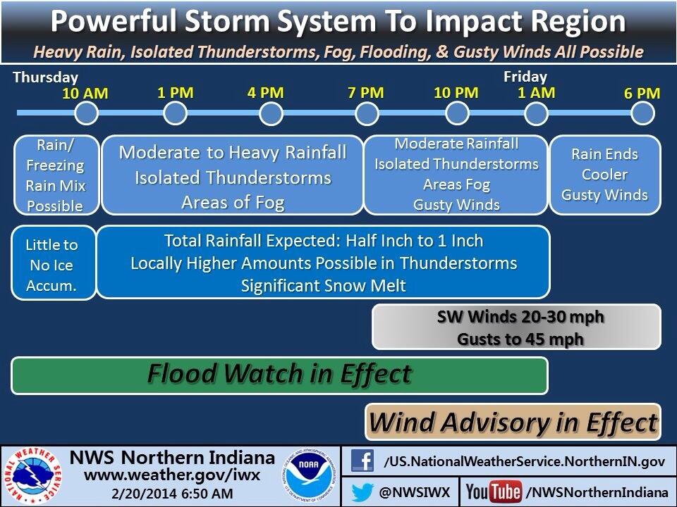
According to a Hazardous Weather Outlook that the northern Indiana NWS office issued at 4:20 a.m. EST, flooding and strong winds are possible today. A flood watch remains in effect because locally heavy rain and melting snow might lead to excessive runoff into low-lying areas, streams and creeks. Read the latest flood watch statement.
After a strong cold front moves through this afternoon or evening, NWS expects a period of strong, southwesterly winds of 30 mph with gusts to 45 mph. That’s why the office issued a Wind Advisory at 3:13 a.m. EST. Read the complete Wind Advisory.
Although the northern Indiana NWS office does not expect that today’s weather will require activation of SKYWARN spotters, the office wrote in its Hazardous Weather Outlook that it will appreciate any reports of flooding. If you’re a spotter, you can make such reports via telephone (to the unlisted spotter number), Twitter (@NWSIWX) or on the office’s Facebook page.