The NWS Spotter training planned for 6:30 pm Tuesday at Notre Dame has been cancelled due to impending weather. Please pass this along. — NWS Northern Indiana (@NWSIWX) February 3, 2014
We cannot host a spotter training during a winter storm while we urge people to stay off the roads in our forecast products. — NWS Northern Indiana (@NWSIWX) February 3, 2014
Continue to monitor the NWS webpage and social media for information about the rescheduled date for the Notre Dame spotter talk. — NWS Northern Indiana (@NWSIWX) February 3, 2014
A National Weather Service meteorologist just advised that they have high confidence that northeastern Indiana and northwestern Ohio will receive at least six inches of snow from Tuesday’s storm (the one for which they issued a Winter Storm Watch this morning). Confidence this morning is low to moderate that we’ll get the higher amounts around 10 inches.
See an update regarding NWS confidence levels in the snowfall forecast
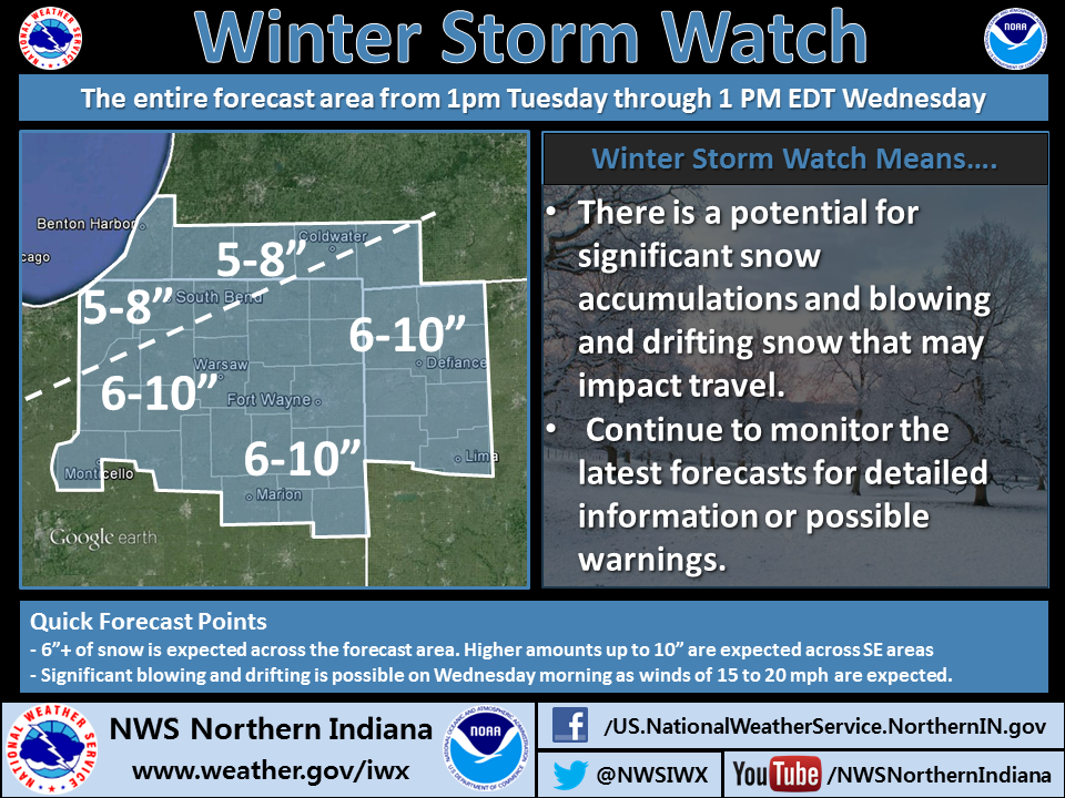
See the NWS infographic above for a synopsis of the current storm forecast. For details, see the full Winter Storm Watch statement below. Note that the forecast snowfall amounts are still subject to change, based on the storm’s actual track and strength. Remember, a Winter Storm Watch means there is a potential for significant snow, sleet, or ice accumulations that may impact travel. Residents of the watch area should continue to monitor the latest forecasts.
URGENT - WINTER WEATHER MESSAGE...CORRECTED
NATIONAL WEATHER SERVICE NORTHERN INDIANA
441 AM EST MON FEB 3 2014

...WINTER STORM DEVELOPING...

.A STRONG STORM SYSTEM WILL MOVE QUICKLY FROM THE SOUTHEAST TEXAS
COAST EARLY TUESDAY AND INTENSIFY AS IT LIFTS NORTHEAST THROUGH
THE TENNESSEE VALLEY AND THEN TO SOUTHWEST PENNSYLVANIA BY
DAYBREAK WEDNESDAY. SNOW WILL QUICKLY OVERSPREAD THE REGION
TUESDAY AFTERNOON FROM THE SOUTHWEST TO THE NORTHEAST AND BECOME
HEAVY AT TIMES TUESDAY NIGHT. SNOWFALL RATES OF 1 TO 2 INCHES PER
HOUR ARE POSSIBLE WITH GREATLY REDUCED VISIBILITIES. TOTAL
SNOWFALL AMOUNTS BY MIDDAY WEDNESDAY IS ANTICIPATED TO BE
GENERALLY IN THE 6 TO 10 INCH RANGE. IN ADDITION...NORTH WINDS
WILL INCREASE AND LIKELY CAUSE SIGNIFICANT AREAS OF BLOWING SNOW
TO DEVELOP WEDNESDAY MORNING...ESPECIALLY IN OPEN AND RURAL
AREAS...PRIMARILY AFFECTING EAST TO WEST ROADWAYS.

THE WINTER STORM WATCH IS BASED ON THE LATEST INFORMATION AND IS
SUBJECT TO CHANGE...DEPENDING ON THE STORM'S EXACT TRACK AND
STRENGTH. LISTEN FOR LATER UPDATES ON THIS DEVELOPING WINTER
STORM.

LA PORTE-ST. JOSEPH IN-ELKHART-LAGRANGE-STEUBEN-NOBLE-DE KALB-
STARKE-PULASKI-MARSHALL-FULTON IN-KOSCIUSKO-WHITLEY-ALLEN IN-
WHITE-CASS IN-MIAMI-WABASH-HUNTINGTON-WELLS-ADAMS-GRANT-BLACKFORD-
JAY-BERRIEN-CASS MI-ST. JOSEPH MI-BRANCH-HILLSDALE-WILLIAMS-
FULTON OH-DEFIANCE-HENRY-PAULDING-PUTNAM-VAN WERT-ALLEN OH-
INCLUDING THE CITIES OF...MICHIGAN CITY...LA PORTE...SOUTH BEND...
MISHAWAKA...NEW CARLISLE...WALKERTON...ELKHART...GOSHEN...
NAPPANEE...LAGRANGE...TOPEKA...SHIPSHEWANA...ANGOLA...FREMONT...
KENDALLVILLE...LIGONIER...ALBION...AUBURN...GARRETT...KNOX...
NORTH JUDSON...BASS LAKE...WINAMAC...FRANCESVILLE...MEDARYVILLE...
PLYMOUTH...BREMEN...CULVER...ROCHESTER...AKRON...WARSAW...
WINONA LAKE...SYRACUSE...MENTONE...COLUMBIA CITY...TRI-LAKES...
SOUTH WHITLEY...FORT WAYNE...NEW HAVEN...MONTICELLO...BROOKSTON...
MONON...LOGANSPORT...ROYAL CENTER...PERU...GRISSOM AFB...MEXICO...
WABASH...NORTH MANCHESTER...HUNTINGTON...ROANOKE...BLUFFTON...
OSSIAN...DECATUR...BERNE...MARION...GAS CITY...UPLAND...
HARTFORD CITY...MONTPELIER...PORTLAND...DUNKIRK...NILES...
BENTON HARBOR...ST. JOSEPH...BUCHANAN...DOWAGIAC...CASSOPOLIS...
MARCELLUS...STURGIS...THREE RIVERS...WHITE PIGEON...MENDON...
COLDWATER...BRONSON...HILLSDALE...LITCHFIELD...JONESVILLE...
BRYAN...WAUSEON...ARCHBOLD...FAYETTE...SWANTON...DEFIANCE...
SHERWOOD...HICKSVILLE...NAPOLEON...DESHLER...LIBERTY CENTER...
PAULDING...ANTWERP...MELROSE...OTTAWA...PANDORA...KALIDA...
FORT JENNINGS...VAN WERT...DELPHOS...OHIO CITY...LIMA...
SPENCERVILLE

...WINTER STORM WATCH IN EFFECT FROM TUESDAY AFTERNOON THROUGH
WEDNESDAY AFTERNOON...

THE NATIONAL WEATHER SERVICE IN NORTHERN INDIANA HAS ISSUED A
WINTER STORM WATCH...WHICH IS IN EFFECT FROM TUESDAY AFTERNOON
THROUGH WEDNESDAY AFTERNOON.

HAZARDOUS WEATHER...

 * SNOW OVERSPREADS TUESDAY AFTERNOON AND EVENING

 * SNOW HEAVY AT TIMES TUESDAY NIGHT

 * TOTAL ACCUMULATIONS OF 6 TO 10 INCHES POSSIBLE

 * AREAS OF BLOWING AND DRIFTING SNOW DEVELOPS WEDNESDAY

IMPACTS...

 * SNOW COVERED ROADS AND REDUCED VISIBILITIES IN OCCASIONAL HEAVY
   SNOW WILL PRODUCE EXTREMELY HAZARDOUS TRAVEL CONDITIONS BY
   TUESDAY NIGHT.

 * DIFFICULT MORNING COMMUTE WEDNESDAY MORNING

 * INCREASING NORTH WIND WEDNESDAY MORNING TO CAUSE
   DRIFTING...PRIMARILY ON EAST TO WEST ROADS

PRECAUTIONARY/PREPAREDNESS ACTIONS...

A WINTER STORM WATCH MEANS THERE IS A POTENTIAL FOR SIGNIFICANT
SNOW...SLEET...OR ICE ACCUMULATIONS THAT MAY IMPACT TRAVEL.
CONTINUE TO MONITOR THE LATEST FORECASTS.
SPECIAL WEATHER STATEMENT
NATIONAL WEATHER SERVICE NORTHERN INDIANA
542 PM EST SUN FEB 2 2014

...WINTER STORM EXPECTED TO IMPACT THE AREA TUESDAY AFTERNOON INTO
WEDNESDAY...

A STORM SYSTEM IS EXPECTED TO STRENGTHEN ACROSS THE SOUTHERN PLAINS
TUESDAY...AND WILL THEN TRACK NORTHEAST INTO THE SOUTHERN GREAT
LAKES AND OHIO VALLEY TUESDAY INTO EARLY WEDNESDAY. SNOW IS
EXPECTED TO OVERSPREAD THE AREA TUESDAY AFTERNOON...AND THEN
BECOME HEAVY AT TIMES TUESDAY NIGHT INTO EARLY WEDNESDAY MORNING.
WHILE THERE IS STILL FORECAST UNCERTAINTY REGARDING THE EXACT
TRACK OF THIS STORM...CURRENT INDICATIONS SUGGEST THAT MUCH OF THE
AREA MAY RECEIVE SNOWFALL AMOUNTS IN EXCESS OF 6 INCHES FROM
TUESDAY AFTERNOON INTO WEDNESDAY MORNING BEFORE SNOW TAPERS
WEDNESDAY AFTERNOON. IF A FARTHER NORTH STORM TRACK VERIFIES...A
WINTRY MIX WILL BE POSSIBLE FOR A TIME ESPECIALLY FOR AREAS SOUTH
OF US ROUTE 24 ON TUESDAY NIGHT. IN ADDITION TO THE POTENTIAL
HEAVY SNOW ACCUMULATIONS...NORTH WINDS ARE EXPECTED TO STRENGTHEN
TO 15 TO 25 MPH LATER TUESDAY NIGHT RESULTING IN THE POSSIBILITY
OF BLOWING AND DRIFTING SNOW THROUGH WEDNESDAY MORNING.

THIS STORM SYSTEM IS STILL IN ITS EARLY STAGES AND LOCATED JUST
OFF THE PACIFIC COAST SUNDAY AFTERNOON. ANYONE PLANNING TRAVEL
ACROSS THE REGION TUESDAY AND WEDNESDAY SHOULD STAY UPDATED ON
THE LATEST FORECASTS...AS FORECAST DETAILS BECOMING FINE TUNED
OVER THE NEXT 36 HOURS REGARDING THIS DEVELOPING STORM SYSTEM.
SKYWARN spotter training presented by the Northern Indiana office of the National Weather Service is scheduled to begin Tuesday, Feb. 4, in South Bend, with additional sessions at other locations planned for the following several weeks. The possibility exists that winter weather might force NWS to cancel one or more of the planned sessions. Recently, the NWS sent an email message to those who have pre-resgistered for a training session, to describe plans for communicating such cancelations. If you have not pre-registered for a training session, doing so here will assue that you will receive email notification, should weather force cancelation of that session. Below is an excerpt of the email message that NWS sent to people who have already registered:
In the event that weather creates hazardous conditions, the National Weather Service may decide to cancel the Spotter Training.
At this time there does not appear to be any reason to think that the event will be cancelled; however, if public safety is a concern, we will work with the local Emergency Management Agency to get the word out as soon as possible.
Check your e-mail (Notification will be sent to your registration e-mail)
Regarding the reference to last night’s thoughts, see the blog post I published last night. As usual, the above-referenced forecast discussion is quite technical, but the way I read it, the gist is that there is still some disagreement between computer forecast models regarding whether the storm will bring all snow to the entire 37-county forecast area, or whether the southeastern portion of the forecast area (e.g., Jay, Blackford, Grant, Wells, Adams and Allen Counties of Indiana and Van Wert County, Ohio) will see mixed precipitation. Also, the discussion indicates that a winter storm watch might be needed by early Monday morning.
THERE IS INCREASING POTENTIAL FOR ANOTHER WINTER STORM TO IMPACT
THE AREA TUESDAY AFTERNOON THROUGH WEDNESDAY MORNING WITH HEAVY
SNOW. PLEASE STAY TUNED TO THE LATEST FORECASTS AND UPDATES
REGARDING THIS POTENTIAL WINTER STORM.

WIND CHILL TEMPERATURES OF 10 TO 20 BELOW ARE EXPECTED WEDNESDAY
NIGHT INTO FRIDAY MORNING.
As we stress with any winter storm, track will greatly impact snow amts. Too uncertain now for specific snow totals at your location — NWS Northern Indiana (@NWSIWX) February 1, 2014
Many questions coming in about snow on Tues/Weds. We will have an update later this evening but focusing on today’s storm 1st — NWS Northern Indiana (@NWSIWX) February 1, 2014
See the tweet above. Also, check out this morning’s Hazardous Weather Outlook:
HAZARDOUS WEATHER OUTLOOK...UPDATED
NATIONAL WEATHER SERVICE NORTHERN INDIANA
411 PM EST SAT FEB 1 2014

INZ006>009-013-015>018-020-022>027-032>034-MIZ081-OHZ001-002-004-005-
015-016-024-025-022115-
LAGRANGE-STEUBEN-NOBLE-DE KALB-PULASKI-FULTON IN-KOSCIUSKO-WHITLEY-
ALLEN IN-WHITE-CASS IN-MIAMI-WABASH-HUNTINGTON-WELLS-ADAMS-GRANT-
BLACKFORD-JAY-HILLSDALE-WILLIAMS-FULTON OH-DEFIANCE-HENRY-PAULDING-
PUTNAM-VAN WERT-ALLEN OH-
INCLUDING THE CITIES OF...LAGRANGE...TOPEKA...ANGOLA...
KENDALLVILLE...LIGONIER...AUBURN...GARRETT...WINAMAC...
FRANCESVILLE...ROCHESTER...WARSAW...WINONA LAKE...COLUMBIA CITY...
SOUTH WHITLEY...FORT WAYNE...MONTICELLO...BROOKSTON...LOGANSPORT...
PERU...WABASH...NORTH MANCHESTER...HUNTINGTON...BLUFFTON...OSSIAN...
DECATUR...BERNE...MARION...HARTFORD CITY...MONTPELIER...PORTLAND...
HILLSDALE...BRYAN...WAUSEON...ARCHBOLD...DEFIANCE...NAPOLEON...
PAULDING...ANTWERP...OTTAWA...PANDORA...VAN WERT...DELPHOS...LIMA
411 PM EST SAT FEB 1 2014

THIS HAZARDOUS WEATHER OUTLOOK IS FOR PORTIONS OF NORTHWEST OHIO...
SOUTHWEST LOWER MICHIGAN AND NORTHERN INDIANA.

.DAY ONE...TONIGHT

RAIN ACROSS MUCH OF THE AREA WILL CHANGE BRIEFLY TO WINTRY MIX
BEFORE CHANGING OVER TO ALL SNOW FROM WEST TO EAST LATE THIS
AFTERNOON INTO EARLY THIS EVENING. DEPENDING ON THE EXACT TIMING
OF THIS CHANGEOVER TO ALL SNOW...THERE IS A POTENTIAL OF SNOWFALL
ACCUMULATIONS OF 1 TO 4 INCHES THROUGH MIDNIGHT.

.DAYS TWO THROUGH SEVEN...SUNDAY THROUGH FRIDAY

THERE IS INCREASING POTENTIAL FOR ANOTHER WINTER STORM TO IMPACT
THE AREA TUESDAY THROUGH TUESDAY NIGHT WITH HEAVY SNOW. PLEASE
STAY TUNED TO THE LATEST FORECASTS AND UPDATES REGARDING THIS
SYSTEM.

.SPOTTER INFORMATION STATEMENT...

SNOWFALL AND PRECIPITATION TYPE REPORTS ARE APPRECIATED.