
There is an old adage in the real estate business that the three most important factors in property value are location, location and location. As SKYWARN storm spotters, the way we report the locations of the severe weather we witness is equally important.
The National Weather Service (NWS) relays many of our reports in a text product it calls a “local storm report.” The way the NWS describes locations in LSRs is informative to spotters. Here’s an example LSR:
 Notice how the LSR gives the location first by identifying the distance and compass direction from the center of the nearest town or village, then by county, then by state. The LSR might then mention a road intersection in the “remarks” section (but it does not always do so).
Whenever we make a spotter report to the NWS, if we don’t indicate our distance and direction from the center of the nearest town or village, some busy NWS staff member must figure that out. We can really help the NWS, therefore, by knowing where we are in relation to the nearest town or village and including that information in our reports.
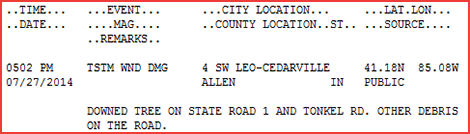
I learn best by example. In case you’re like that, below are some actual spotter reports from an NWS transcript of a recent severe weather event, followed by an example of how the location information could have been more helpful:
Original report: Nearly quarter-size hail, SR 13 and South County Line Road.
More helpful: Kosciusko County, 1 mile north of Syracuse, intersection of state road 13 and the Kosciusko-Elkhart county line.
Original report: U.S. 33 and State Road 205, about 2 minutes Duration, Dime-size hail.
More helpful: Whitley County, in Churubusco, intersection of US 33 and SR 205.
Original report: State Road 427 at Allen-DeKalb county line. About 3 min of dime-size hail. Estimated 50-60 MPH winds. Heavy rain.
More helpful: DeKalb County, 7 miles south of Auburn, intersection of DeKalb County Road 427 and the Allen-DeKalb County line. (Side note: As spotters, we should try to remain aware of the correct and current names of the roads we are using. The road that runs between Fort Wayne and Auburn was once called “State Road 427” but ceased to be a state road years ago. In DeKalb County, it is now called “County Road 427” and in Allen County, it is correctly known as “Tonkel Road.” Because this spotter was at the county line, he could also have given his location as, “Allen County Indiana, 4.5 miles northwest of Leo-Cedarville, intersection of Tonkel Road and the Allen-DeKalb county line” (making the road and town name match the county name))
Original report: Edgerton Road and County Line Road, 1.5 minutes of dime-size hail and measured 57 mph winds.
More helpful: Allen County Indiana, 4 miles southeast of Woodburn, intersection of Edgerton Road and the Indiana-Ohio line. (Note: when at a county line, it is helpful to give the names of both counties to reduce ambiguity. If the county line is also a state line, identifying the state line is probably more helpful).
Original report: Pea-Size hail between Hamilton and Yoder roads on Smith Road. 1 min duration.
More helpful: Allen County Indiana, 1.5 miles northwest of Yoder, Smith Road between Hamilton Road and Yoder Road. (Alternatively, “2.5 miles south of Fort Wayne International Airport” might have been just as helpful at “1.5 miles northwest of Yoder.”)
As a spotter myself, I know it can be challenging to figure out how far I am “as the crow flies” from the nearest town, especially in the excitement of seeing a funnel cloud. But if you think it’s challenging from where you are, imagine what it must be like for a very busy NWS meteorologist, who is handling reports from any of 37 counties. I therefore offer these recommendations:
- When possible, pick a location from which to watch the skies and stay there. After you arrive, and before the weather gets severe, use a map to figure out the approximate distance and direction to the center of the nearest village, town or city. Many experienced spotters always spot from one of a few locations and therefore become familiar not only with how to describe those locations, but also how far away various visible landmarks are. This is good practice.
- If you’ve just moved to a location from which you haven’t spotted before, reportable weather is already there and you don’t have time to consult a map to see how far your are from, say, the center of East Joeville, take your best guess. Even an estimate will help, when combined with the county you’re in and a road intersection.
- If you’re spotting from inside the city limits of a large city like Fort Wayne, it’s probably more helpful to report your location as what part of town you’re in. For example, “Allen County Indiana, extreme northern Fort Wayne, intersection of Dupont Road and Coldwater Road” might make more sense than “Allen County, Indiana, 7 miles north of Fort Wayne, intersection of Dupont Road and Coldwater Road.” While that intersection is about 7 miles from the center of the city, some might infer from “7 miles north of Fort Wayne” that you’re outside of the city, when in fact that intersection is within the city.
- Include the intersection information. Even if NWS doesn’t need it, it is helpful to other spotters, broadcasters and emergency managers.
- Remember that the quadrant served by the 146.88 MHz repeater includes two Allen Counties; one in Indiana and one in Ohio. Therefore, whenever your location is in Allen County, include the state name. Even though it might be obvious to others on the frequency, it can be helpful to NWS staff members.
In case we forget to include our distance and direction from the center of the nearest town, I’ve asked IMO SKYWARN quadrant two net control station (NCS) operators to request that information, when time permits. If the frequency is flooded with reports, there might not always be time for such inquiries, but NCS operators should ask whenever time permits and a spotter forgets to provide the information.
If you have comments about this, please use the comment link, found just under the article title. If you think other storm spotters will find this article helpful, please use one or more of the sharing buttons below.