day1probotlk_20160202_1300_titled

Indiana maps showing probabilities of damaging straight-line thunderstorm winds or gusts of 58 mph or greater (left) or tornadoes (right) within 25 miles of any point between 8 a.m. EST today and 7 a.m. EST Wednesday. Red shading: 30% (enhanced wind risk). Yellow: 15% (slight wind risk, enhanced tornado risk). Brown: 5% (marginal wind risk, slight tornado risk). Green: 2% (marginal tornado risk). Unshaded: Less than 5% (wind) or less than 2% (tornado). Source: SPC "Day 1 Convective Outlook" issued at 8:01 a.m. EST.

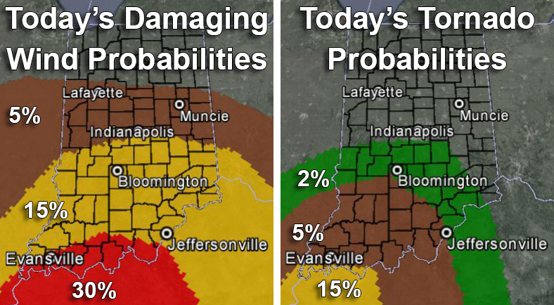
Probabilities of damaging straight-line thunderstorm winds or gusts of 58 mph or greater (left) or tornadoes (right) within 25 miles of any point between 8 a.m. EST today and 7 a.m. EST Wednesday. Red shading: 30% (enhanced wind risk). Yellow: 15% (slight wind risk, enhanced tornado risk). Brown: 5% (marginal wind risk, slight tornado risk). Green: 2% (marginal tornado risk). Unshaded: Less than 5% (wind) or less than 2% (tornado). Source: SPC “Day 1 Convective Outlook” issued at 8:01 a.m. EST.

Leave a Reply

Your email address will not be published. Required fields are marked *

This site uses Akismet to reduce spam. Learn how your comment data is processed.