
Keep an eye on the weather today, there's still a chance for a few strong/severe storms this afternoon & evening. pic.twitter.com/PaVxylPquK
— NWS Northern Indiana (@NWSIWX) May 11, 2014
Monthly Archives: May 2014
Slight risk of severe weather in Indiana today

Almost all of Indiana has a slight risk of severe thunderstorms late this afternoon and this evening, according to the Day 1 Convective Outlook the National Weather Service Storm Prediction Center issued at 12:22 p.m. EDT.
The greatest threats are damaging straight-line winds and large hail.
NWS Tweet: Isolated severe storms possible in northeastern Indiana
If you are west of this line your severe chances are gone. Isolated severe east of here pic.twitter.com/tdgeITRQg8
— NWS Northern Indiana (@NWSIWX) May 9, 2014
Updated outlook removes northern Indiana from slight risk area

Northern Indiana is no longer at risk of severe weather today, according to an updated “Day 1 Convective Outlook” the National Weather Service Storm Prediction Center issued at 12:20 p.m. EDT. As you can see on the map at right, the newly-draw slight risk area includes most of the southern half of Indiana but no longer includes northern Indiana.
Atmospheric instability appears to be insufficient for severe thunderstorms to develop in northern Indiana this afternoon, in part because of insufficient sunshine to create surface heating.
Non-severe thunderstorms remain forecast, however. Some of these could contain winds to 40 mph and small hail.
Slight risk of severe weather in most of Indiana today

Almost the entire state of Indiana, including most northeastern counties, has a slight risk of severe thunderstorms between 8 a.m. EDT this morning and 8 a.m. EDT tomorrow morning, according to the “Day 1 Convective Outlook” that the National Weather Service (NWS) Storm Prediction Center issued at 7:50 a.m. today. The storms are mostly likely this afternoon and through this evening.
The main threat is damaging straight-line winds and large hail. The Indiana portion of the slight risk area has only a two percent probability of a tornado within 25 miles of a point (less than a “slight” risk) and a 15 percent probability of either of the following within 25 miles of a point: damaging thunderstorm winds or wind gusts of 50 knots (58 mph) or greater or one inch diameter or larger hail. Remember that compared the precipitation probabilities we see all the time, 15 percent might not seem impressive, but it’s probably at least 10 times greater than our normal probability for this date. Read more about severe weather probabilities
As I write this, the sky is overcast, which limits the potential for severe storms later today. But if the clouds break up later, the risk of severe weather will rise as the amount of sunshine increases.
As you can see on the map above right, the slight risk area covers almost all of Indiana, with the few exceptions including the northernmost tier of counties (Steuben west to Lake), and a few counties in extreme southeastern Indiana (near Cincinnati). In IMO SKYWARN quadrant two, the slight risk area includes all Indiana counties and Paulding and Van Wert Counties of Ohio.
SKYWARN storm spotter activation might be needed by this afternoon and evening, according to the “Hazardous Weather Outlook” that the northern Indiana NWS office issued at 4:27 a.m. EDT.
What to do with this information
Make sure that if the NWS issues any watches or warnings today, you’ll know about it. If you won’t be near your weather alert radio for any part of the day or evening, keep a television or broadcast radio tuned to a local station. You can also receive watches and warnings numerous other ways (see my earlier blog, “Better alternatives to tornado sirens“).
If you’re a trained NWS storm spotter, check your gear and fuel up your vehicle this morning, so you’ll be ready to go, should spotter activation occur this afternoon or evening.
Slight risk of severe storms tomorrow evening in central and southern Indiana

Much of central and southern Indiana continues to be have a slight risk of severe thunderstorms tomorrow, according to the Day 2 Convective Outlook that the National Weather Service Storm Prediction Center issued at 1:49 a.m. today. The greatest risks are for damaging straight-line wind gusts and severe hail produced by lines of storms in the late afternoon and early evening tomorrow.
As you can see on the map above right, the slight risk area includes most of the western half of Indiana, with the exception of some northern counties. The slight risk area includes the cities of Logansport, Marion, Kokomo, Lafayette, Indianapolis, Terre Haute, Bloomington, Evansville and others. Its northern edge includes all or significant parts of the following counties: Benton, White, Cass, southern Miami, southern Wabash and extreme southwestern Huntington.
The SPC will update its day two outlook for this period by 1:30 p.m. EDT. After that, our next outlook for Friday will arrive with the first day one outlook at around 1 a.m.
Meanwhile, northern Iowa and southern Minnesota is in a bull’s eye for severe weather today, where the SPC is forecasting supercell thunderstorms this afternoon. Forecasters expect tornadoes — some of which could be strong — as well as large, damaging hail and sporadic severe straight-line wind gusts in that area. This moderate risk area for today runs from just south of Minneapolis south to and including Des Moines.
Slight risk of severe weather in central Indiana Friday
 |
| Yellow area: Slight risk of severe thunderstorms Friday, including hail and damaging straight-line winds. Green area: Thunderstorms but insignificant risk of severe thunderstorms. |
Portions of central Indiana have a slight risk of severe weather between 8 a.m. EDT Friday and 8 a.m. EDT Saturday, according to a Day 3 Convective Outlook that the National Weather Service Storm Prediction Center (SPC) issued at 3:20 a.m. EDT today. Hail and damaging straight-line winds are the greatest threats and these are most likely Friday evening.
As you can see on the map above, the slight risk area includes the following Indiana counties and other counties to the south and west of them: Benton, White, Cass, southern Miami, southern Wabash, southwestern Huntington and Grant.
Because this forecast is for more than 48 hours form now, there is some uncertainty regarding where severe weather might form. Our next look at the risks of severe weather will come with the Day 2 Convective Outlook that the SPC will issue at around 2 a.m. EDT tomorrow.
Miss. residents learn the hard way not to rely on tornado sirens
People in Tupelo, Miss. are up in arms about the fact that they didn’t hear tornado sirens when a an EF-3 tornado hit that town Monday, April 28. As a news story on a TV station’s website indicates, there’s some controversy over whether the siren system worked right.
One of the best quotes in that story comes from Mississippi State Climatologist Michael Brown: “Tupelo learned a good lesson – that you shouldn’t rely on sirens.”
As frequent readers of this blog know, I’ve been beating that drum as well. Today, I found a PDF file online that shows graphically how much of Fort Wayne and Allen County, Indiana are not covered by tornado sirens. These dead spots are places where you might not to hear a siren, even if you’re outdoors and even if all the sirens activate properly. A reduced version of that map appears below.
So, don’t rely on tornado sirens. A tornado could be bearing down on your house and you might never hear a siren. There are plenty of other ways to be warned and I think the best is a weather alert radio. These devices are available at a discount right now at several retail stores in the Fort Wayne area, including Walgreens. If you don’t have one, get one. Program it to remain silent unless a warning includes your county. Put it someplace in your house where it will wake you if an alert goes out. Put fresh batteries in it every six months, so it will wake you even if a storm takes out your power. And above all,
stop relying on outdoor warning sirens!
If you have friends or family members who don’t yet have a weather alert radio, please use the sharing buttons below to share this post via Facebook, Twitter, etc.
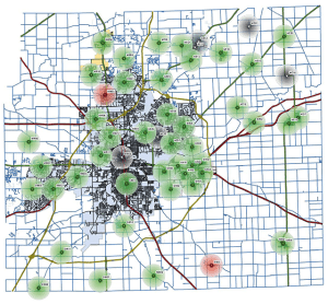 |
| Outdoor warning siren coverage map for Allen County, Indiana (see a full-size map as a PDF file). If you are not in one of the colored circles, you might not hear anything when the county activates the siren system. Even inside a circle, you might not hear a siren unless you are outdoors. That’s why you must have another means of knowing about weather dangers. |