
Monthly Archives: March 2014
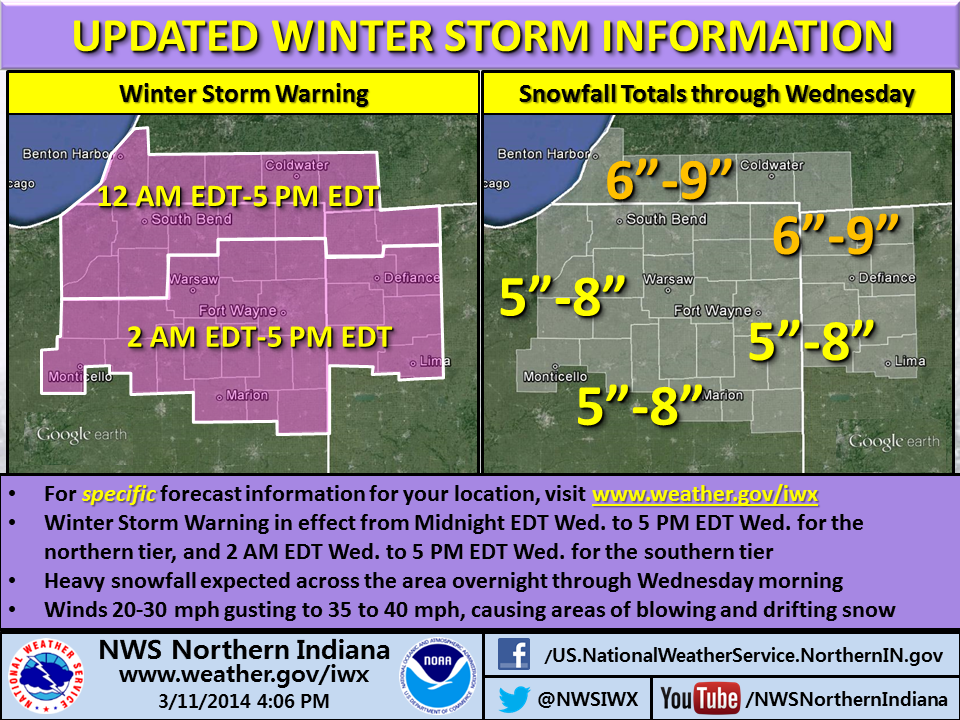
Winter Storm Warning issued: 5-9 inches, high winds, drifting, power outages

 |
| Pink area indicates counties included in Winter Storm Warning (NWS map, 4 p.m. EDT March 11). |
Update: View a multimedia briefing on this storm.
The northern Indiana office of the National Weather Service has upgraded its previously-issued Winter Storm Watch for tonight and tomorrow to a Winter Storm Warning for its entire forecast area, including southeastern counties that the watch had excluded. The warning is in effect from 2 a.m. to 5 p.m. EDT tomorrow (Wednesday) for the southern part of the forecast area, including Allen County, Ind. It begins at 12:00 a.m. for northern counties (see graphic at bottom).
The warning forecasts five to eight inches of snow in southern parts of the 37-county forecast area and six to nine inches in northern counties. In addition, the NWS forecasts snowfall rates “in excess of an inch per hour” and winds of 20 mph to 30 mph gusting to 35 to 40 mph, causing “considerable blowing and drifting snow” and hazardous travel late tonight and Wednesday.The strong winds might also blow down tree branches and cause power outages.
See the latest verbatim statement from the NWS.
Why the change to a warning? The snowfall forecast increased for the warning area but what seems to have really helped meteorologists make the decision are the potential travel disruption from drifting snow and the potential power outages from high winds combined with heavy, wet snow.
The NWS infographic below shows meteorologists’ current thinking as to timing and accumulation. Free free to use the social media sharing buttons below the infographic to share this information with others. Also, feel free to use the comment facility to share your thoughts and/or questions.
Go Dons!
#IPFWmbb will face No.1 seed North Dakota State tomorrow at 9pm (ET), the game will be live on @espn-2 and on the radio @TheFanFortWayne
— IPFW Mastodons (@IPFWAthletics) March 11, 2014
Note the date stamp on the tweet above. The games is tonight!
NWS updates snowfall forecast

The northern Indiana office of the National Weather Service issued the above infographic this morning, with their latest thinking on the coming snow storm. Note the sentence that indicates the continued existence of some uncertainty regarding the exact track and timing.
See the latest Winter Storm Watch, which remains effect for all but the southeastern-most counties of the forecast area. See the latest Special Weather Statement for the remaining counties.
Also, see the tweet below:
Want to know how much snow we’re forecasting for YOUR location? Here’s how to find out: pic.twitter.com/HRiC7IN3tT
— NWS Northern Indiana (@NWSIWX) March 11, 2014
NWS issues winter storm infographic

NWS issues Winter Storm Watch for Tuesday night and Wednesday

 |
| Blue area: Winter Storm Watch: Peach area: Special Weather Statement. |
The northern Indiana office of the National Weather Service has issued a Winter Storm Watch for most of its forecast area — including Allen County, Indiana — for midnight EST Tuesday night until 5 p.m. EST Wednesday. It issued a Special Weather Statement for its southeastern-most counties, including Grant, Blackford, Jay, Adams Wells, Van Wert, and Allen (Ohio).
Precipitation will likely begin as a period of rain along and south of a Winamac, Indiana to Warsaw, Indiana to Bryan, Ohio line before changing over to all snow from the northwest to southeast, according to the watch statement. Snow accumulations are forecast to generally range between four and eight inches. In addition, sustained winds of 15 to 25 mph with gusts to 35 mph will create areas of blowing snow and hazardous travel in the region Wednesday.
Forecasters expect the southeastern counties covered by the Special Weather Statement to get more rain, with snowfall totals ranging from three to six inches.
See the verbatim Winter Storm Watch (it’s in two sections .. .be sure to scroll to the section that mentions your county). See the verbatim Special Weather Statement.
Exact location of Tuesday night’s heaviest snow remains uncertain

Accumulating snowfall remains likely across northeastern Indiana, southern lower Michigan and northwestern Ohio Tuesday night and Wednesday, according to a Hazardous Weather Outlook issued at 5:51 a.m. by the northern Indiana office of the National Weather Service (NWS). The area could get several inches of snow, but the exact location of the heaviest snowfall remained uncertain at that time.
Meteorologists expect to have the data they need later today to make more accurate forecasts, according to the Area Forecast Discussion the northern Indiana NWS office issued at 6:52 a.m. It indicates that the office might need to issue a winter weather advisory for the system, especially for the period between 2 a.m. and 2 p.m. Wednesday.
As Tuesday night approaches, keep an eye on www.weather.gov/iwx for the latest forecast updates.
Midweek storm expected to bring more snow

Forecasters expect another snow storm to hit northern Indiana and northwestern Ohio Tuesday night and Wednesday. According to the graph above, which the northern Indiana National Weather Service office issued at 1:48 p.m., There’s a 50 percent or better chance of at least three inches of snow in the area that office covers.
While some uncertainly still exists in the forecast — and the forecast could change with small changes in the track of the storm — forecasters currently expect most of the snow to fall south of approximately U.S. 6.
To stay up to date on the forecast, or to see snowfall forecasts for your specific location, visit www.weather.gov/iwx.
SKWYARN quadrant net makes small changes

The net control station (NCS) team for the IMO SKYWARN Quadrant Two Net on 146.88 MHz has made some slight operational changes as we enter the 2014 severe weather season.
The main change affects when directed SKYWARN nets will begin. Effective immediately, a directed net will begin any time a tornado warning is issued for any part of Allen County, Ind. In addition, if a liaison from a county SKYWARN net requests a directed quadrant net, a directed net will begin. Finally, SKYWARN NCS have the authority to begin a directed net at any time they deem it necessary. In general, an NCS will begin a directed net anytime the amount of spotter traffic or expected traffic warrants disrupting normal repeater operation.
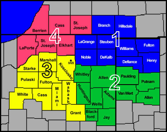 |
| IMO SKYWARN quadrant map. Counties in quadrant two (green) may relay reports via the quadrant two net on the 146.88 MHz repeater in Fort Wayne.The “IWX” in northeastern Kosciusko County represents the approximate location of the northern Indiana NWS weather forecast office. |
Please remember that when a directed net is in session, all stations are requested to refrain from transmitting on the frequency except when they have observed something that meets National Weather Service (NWS) reporting criteria (or when the NCS requests information from them). During a directed net, stations should not transmit information obtained from broadcasters, announce the activation of sirens, etc. as such transmissions are not first-hand reports that meet NWS criteria.
Because of the second minor change in procedures, stations should not plan to use the SKYWARN net as a primary means of obtaining information from the NWS (e.g. warnings, special weather statements, etc.). With today’s technology, even spotters in the field have multiple other means of receiving such information, including portable NOAA weather radios (or amateur radios tuned to the NOAA frequency), broadcast radios, mobile Internet connections and smartphone apps. For this reason and to keep the frequency as clear as possible for spotter reports, net control stations will now severely limit the reading of NWS products on the air, especially during directed nets. Expect, for example, to hear little more than, “A severe thunderstorm warning has been issued for northern Allen County, Indiana.” If you want the details, such as storm location and movement, obtain them via other means. If you haven’t been paying attention to the frequency and want to know why you’re hearing sirens, turn to broadcast or Internet sources, rather than requesting such information during a directed SKYWARN net.
Of course, when SKYWARN is in standby mode, all stations are welcome to transmit at any time and for any purpose, as long as they keep transmissions short and leave long gaps between transmissions so a spotter can easily break in.
Download an updated copy of the quadrant two net operations manual.The manual gives more details regarding the directed net and standby modes, including the preferred way to check in with reports.
Remember that in the past year, the 146.88 MHz repeater was unreliable (mostly when the weather was warm). As in the past, should the repeater develop problems during a SKYWARN operation, SKWYARN will switch to the 146.76 MHz repeater.
NWS appoints new leader for northern Indiana office
 |
| Mark Frazier, incoming meteorologist in charge, National Weather Service northern Indiana office (Grand Forks Herald photo) |
The National Weather Service (NWS) has appointed Mark Frazier to the position of meteorologist in charge (MIC) at its northern Indiana forecast office in Syracuse, Ind. Frazier will succeed Mike Sabones, who retired at the beginning of 2013.
Frazier is currently MIC at the Grand Forks, N.D. office and has nearly 24 years of experience with the NWS. Frazier began his career in weather forecasting as a meteorologist with the NWS Office in Pittsburgh in 1991, after receiving a bachelor’s degree in meteorology from The Ohio State University in 1989. He was promoted to a general meteorologist position in 1994 and promoted to senior meteorologist in 1999, both at the Memphis, Tenn. NWS office. In November 2003, Frazier became warning coordination meteorologist at the Shreveport, La. office and in 2007, he was promoted to MIC in Grand Forks.
Frazier has been directly involved with several significant weather events during his career, including nor’easters, tornado outbreaks, hurricanes, blizzards, and record flooding of the Red River of the North. While Frazier was at the Shreveport office, it received the National Oceanic and Atmospheric Administration (NOAA) Bronze Award after Hurricane Rita of 2005. From 2009 to 2011, the Grand Forks office received the Department of Commerce Silver and NOAA Bronze awards for its handling of major to record Red River of the North flood events.
Frazier’s official reporting date at the northern Indiana office is May 4