Guest blog: Valuable resources for weather historians

1957 weather map
Daily Weather Map from 1957

Guest post by Michael Lewis, KG4KJQ
National Weather Service, Northern Indiana

When I was the science and operations officer in Jackson, Ken. and as the meteorologist in charge in Hastings, Neb., I used to do all kinds of digging through the historic archives for “significant” weather events.

You might find this interesting and there may be others who would as well. This is a must have for every history buff.

U.S. Daily Weather Maps
Publication History

The U.S. Signal Office began publishing weather maps as the War Department Maps on Jan. 1, 1871. When the meteorological activities of the Signal Corps were transferred to the newly-created Weather Bureau in 1891, the title of the weather map changed to the Department of Agriculture Weather Map. In 1913, the title became simply Daily Weather Map. In 1969, the Weather Bureau began publishing a weekly compilation of daily maps with the title Daily Weather Maps (Weekly series).

These maps can be downloaded from the NOAA Central Library: http://www.lib.noaa.gov/collections/imgdocmaps/daily_weather_maps.html

To view/print the maps requires the installation of a free browser plug-in. http://www.caminova.net/en/downloads/download.aspx?id=1

Michael Lewis, KG4KJQ is warning coordination meteorologist at the northern Indiana forecast office of National Weather Service, Syracuse, Ind.

Some Indiana residents receive tornado warning in error

Update: My contact at the National Weather Service (NWS) provided the following information this morning: There are now a lot of federal agencies investigating the cause/origin of this event. NWS will release the details as soon as possible after all investigations are complete. There is just not enough concrete evidence to state with certainty what actually happened or how.

Tornado warnings went out over the Emergency Alert System Tuesday morning in parts of northwestern Indiana, according to various sources. The alerts were heard on radio and television stations and received by individuals on cell phones that support Wireless Emergency Alerts. The northern Indiana office of the NWS had nothing to do with the alerts, as it tweeted Tuesday:

We’ve verified that this morning’s false tornado warning was not sent out from our office. We’re continuing to investigate the matter.
— NWS Northern Indiana (@NWSIWX) March 4, 2014

An article by Lafayette’s “Journal and Courier” newspaper indicates that the Indianapolis and Chicago NWS offices didn’t send the alert either. The Associated Press also ran a version of the article, which appeared on the websites of many publications and broadcast outlets.

I have seen no coverage that indicates the geographic area covered by the erroneous warning, but it apparently did not reach the Fort Wayne area. I sent a note to a contact at the northern Indiana office to ask whether any more is yet know. When I learn more, I’ll post it here.

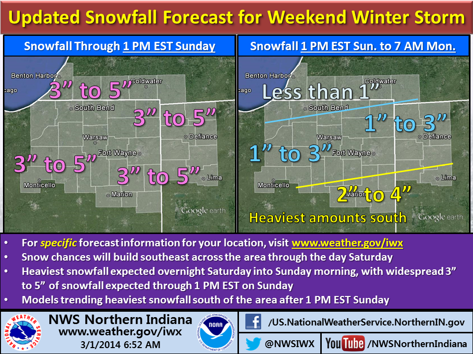
NWS revises weekend snowfall forecast for northeastern Indiana, northwestern Ohio

Winter storm infographic

All signs continue to point toward accumulating snowfall arriving towards evening in far northwestern parts of the northern Indiana National Weather Service office’s coverage area, according to an Area Forecast Discussion the office issued at 10:37 a.m. EST. Meteorologists expect the snow to expand southeastward during the evening with peak snowfall between 10 p.m. EST and 10 a.m. EST Sunday.

The NWS expects most areas to see a uniform 2 to 4 or 3 to 5 inches of snow by Sunday morning, with locally higher amounts possible. The office plans to leave the current Winter Storm Watch in place for now, but indicated that it might replace it with a Winter Weather Advisory by early afternoon, depending on data from computer forecast models.

Check the NWS northern Indiana website, www.weather.gov/iwx, for the latest information and to obtain the snowfall forecast for your specific area.