NWS posted the infographic below at 6:33 p.m.


NWS posted the infographic below at 6:33 p.m.
WANE-TV meteorologist Jesse Hawila posted the video below at 5:55 p.m. EST today. He gives a good explanation of what meteorologists are worried about. Take a look:
At 2:16 p.m., the northern Indiana office of the National Weather Service sent the following tweet:
If you live in Indiana or surrounding states, now is a good time to refresh your member on tornado safety. Here’s a link to important, reliable safety information that the northern Indiana NWS office sent out today.

URGENT - WEATHER MESSAGE
NATIONAL WEATHER SERVICE NORTHERN INDIANA
331 PM EST SAT NOV 16 2013

...STRONG GUSTY WINDS EXPECTED SUNDAY AFTERNOON AND EVENING...

.SOUTHERLY WINDS OF 25 TO 30 MPH WITH GUSTS UP TO 50 MPH SUNDAY
AFTERNOON WILL BECOME WESTERLY BY SUNDAY EVENING BEHIND A STRONG
COLD FRONT. HIGHER GUSTS AND SIGNIFICANT WIND DAMAGE WILL BE
POSSIBLE WITH ANY THUNDERSTORMS.

INZ003>009-012>018-020-022>027-032>034-MIZ077>081-OHZ001-002-004-
005-015-016-024-025-170445-
/O.NEW.KIWX.WI.Y.0006.131117T1700Z-131118T0300Z/
LA PORTE-ST. JOSEPH IN-ELKHART-LAGRANGE-STEUBEN-NOBLE-DE KALB-
STARKE-PULASKI-MARSHALL-FULTON IN-KOSCIUSKO-WHITLEY-ALLEN IN-
WHITE-CASS IN-MIAMI-WABASH-HUNTINGTON-WELLS-ADAMS-GRANT-BLACKFORD-
JAY-BERRIEN-CASS MI-ST. JOSEPH MI-BRANCH-HILLSDALE-WILLIAMS-
FULTON OH-DEFIANCE-HENRY-PAULDING-PUTNAM-VAN WERT-ALLEN OH-
INCLUDING THE CITIES OF...MICHIGAN CITY...LA PORTE...SOUTH BEND...
MISHAWAKA...NEW CARLISLE...WALKERTON...ELKHART...GOSHEN...
NAPPANEE...LAGRANGE...TOPEKA...SHIPSHEWANA...ANGOLA...FREMONT...
KENDALLVILLE...LIGONIER...ALBION...AUBURN...GARRETT...KNOX...
NORTH JUDSON...BASS LAKE...WINAMAC...FRANCESVILLE...MEDARYVILLE...
PLYMOUTH...BREMEN...CULVER...ROCHESTER...AKRON...WARSAW...
WINONA LAKE...SYRACUSE...MENTONE...COLUMBIA CITY...TRI-LAKES...
SOUTH WHITLEY...FORT WAYNE...NEW HAVEN...MONTICELLO...BROOKSTON...
MONON...LOGANSPORT...ROYAL CENTER...PERU...GRISSOM AFB...MEXICO...
WABASH...NORTH MANCHESTER...HUNTINGTON...ROANOKE...BLUFFTON...
OSSIAN...DECATUR...BERNE...MARION...GAS CITY...UPLAND...
HARTFORD CITY...MONTPELIER...PORTLAND...DUNKIRK...NILES...
BENTON HARBOR...ST. JOSEPH...BUCHANAN...DOWAGIAC...CASSOPOLIS...
MARCELLUS...STURGIS...THREE RIVERS...WHITE PIGEON...MENDON...
COLDWATER...BRONSON...HILLSDALE...LITCHFIELD...JONESVILLE...
BRYAN...WAUSEON...ARCHBOLD...FAYETTE...SWANTON...DEFIANCE...
SHERWOOD...HICKSVILLE...NAPOLEON...DESHLER...LIBERTY CENTER...
PAULDING...ANTWERP...MELROSE...OTTAWA...PANDORA...KALIDA...
FORT JENNINGS...VAN WERT...DELPHOS...OHIO CITY...LIMA...
SPENCERVILLE
331 PM EST SAT NOV 16 2013 /231 PM CST SAT NOV 16 2013/

...WIND ADVISORY IN EFFECT FROM NOON EST /11 AM CST/ TO 10 PM EST
/9 PM CST/ SUNDAY...

THE NATIONAL WEATHER SERVICE IN NORTHERN INDIANA HAS ISSUED A
WIND ADVISORY...WHICH IS IN EFFECT FROM NOON EST /11 AM CST/ TO
10 PM EST /9 PM CST/ SUNDAY.

HAZARDOUS WEATHER...

 * SOUTHERLY WINDS OF 25 TO 30 MPH WITH GUSTS UP TO 50 MPH SUNDAY
   AFTERNOON WILL TURN WESTERLY BY SUNDAY EVENING.

 * HIGHER GUSTS AND SIGNIFICANT WIND DAMAGE WILL BE POSSIBLE WITH
   ANY THUNDERSTORMS.

IMPACTS...

 * SCATTERED POWER OUTAGES POSSIBLE.

 * WINDS STRONG ENOUGH TO MAKE DRIVING DIFFICULT IN OPEN AREAS.

PRECAUTIONARY/PREPAREDNESS ACTIONS...

A WIND ADVISORY MEANS THAT SUSTAINED WINDS OF 30 MPH...OR GUSTS
OVER 45 MPH ARE EXPECTED. WINDS THIS STRONG CAN MAKE DRIVING
DIFFICULT...ESPECIALLY FOR HIGH PROFILE VEHICLES. USE EXTRA
CAUTION.
 |
| Probability of of severe weather within 25 miles of a point. Hatched Area: 10% or greater probability of significant severe weather within 25 miles of a point. (More Info) |
Indiana, Ohio and the southern half of lower Michigan are in a bulls eye for severe weather tomorrow. There’s a moderate risk of severe weather as well as an enhanced risk of significant severe weather between 8 a.m. EST Sunday, Nov. 17 and 8 a.m. EST Monday, according to the Day 2 Convective Outlook that the National Weather Service (NWS) Storm Prediction Center (SPC) issued at 12:32 p.m. EST today.
As you can see on the map at left, the outlook indicates a 45 percent probability of severe weather and a 10 percent probability of significant severe weather. The SPC defines significant severe weather as F2 or greater tornadoes, damaging winds with speeds greater than 65 knots (74.8 mph), or large hail 2 inches or greater in diameter. To better understand probability figures, see this excellent explanation on the SPC website.
Here’s the basic setup: A surface low pressure system is forecast to undergo significant deepening as it moves from the upper Mississippi Valley into the Great Lakes region by tomorrow afternoon. A cold front trailing from the low will sweep through the mid-Mississippi, Ohio and Tennessee Valleys, while a warm front lifts northward through the Great Lakes region.
The potential exists for a widespread damaging wind event and a few tornadoes tomorrow afternoon and tomorrow night, especially in and near the moderate (45 percent) risk area across parts of the Ohio Valley and Great Lakes. Depending on how the situations develops, discrete supercell thunderstorms are possible, as well as an organized, bowing line of storms capable of producing widespread damaging straight-line wind. Isolated tornadoes associated with embedded meso-vortices will also be possible with that line of storms.
This morning, the northern Indiana NWS forecast office, put the infographic and statement below on its Facebook page:

“PLEASE SHARE…A Severe Weather Outbreak is likely for Sunday. The risk for severe weather will start early in the morning and last all day. The greatest risk is for damaging winds and tornadoes. There is a slight chance for an isolated strong tornado, especially if any discrete storms can form ahead of the cold front. The severe weather threat will diminish in the evening as the cold front moves across the forecast area. Fall severe weather outbreaks are not uncommon for our forecast area and should not be taken lightly. Notify friends and family so they are not caught off guard by this severe weather outbreak.”
In addition, the northern Indiana office sent out a tweet at midday today that reads, “Before potentially serious weather events we have conference calls with Emergency Management and Media. Today is one of those days.”
In the Hazardous Weather Outlook that the northern Indiana office put out at 4:29 a.m. EST, we find the following notification for SKYWARN storm spotters: “Spotter activation will likely be needed Sunday in to early Sunday evening.”
Watch the northern Indiana office’s Facebook page and Twitter feed for updates on this situation throughout the day today. The next outlook for tomorrow from the SPC isn’t due until they issue a Day 1 Convective Outlook early tomorrow morning.

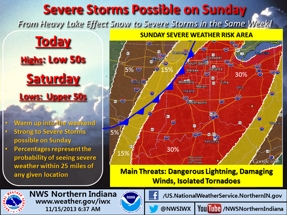
The infographic above shows the thinking of the northern Indiana office of the National Weather Service (NWS) as of midday Friday, Nov. 15, regarding the threats for severe weather Sunday. The information applies to all 37 Indiana, Michigan and Ohio counties covered by the northern Indiana office.
First severe storms could be seen as early as 10 am.
Severe threat will diminish after 8pm once the cold front moves through.
A line of thunderstorms will form along the cold front with a high risk for damaging winds
Tornadic circulations are possible along this line. There is a slight risk for low-topped supercell development ahead of this line with a risk of damaging winds and tornadoes
While there is still some uncertainty regarding the extent of the severe weather potential in our forecast area, there is increasing confidence that portions of the forecast area will see severe weather on Sunday. The tornadic threat is still quite uncertain, although there is at least a slight chance for a significant tornadic event.
Watch this blog, the NWS office’s Facebook page and/or the NWS office’s Twitter feed for updates as the weather system approaches.
The warning coordination meteorologist at the northern Indiana National Weather Service forecast office, Michael Lewis, has advised that the office will continue to publish information like this on its website and Facebook page as a stormy Sunday approaches.
Lewis advises SKYWARN storm spotters to check communications tools now, to assure they’re working properly in advance of Sunday’s weather.

The entire states of Indiana and Ohio, plus the southern half of lower Michigan are at slight risk of severe weather between 8 a.m. EST Sunday, Nov. 17 and 8 a.m. EST Monday, Nov. 18, according to a Day 3 Convective Outlook that the National Weather Service (NWS) Storm Prediction Center (SPC) issued at 3:30 a.m. EST today.
Forecasters say a deepening low pressure system will move northeastward from the upper Mississippi Valley into the Great Lakes region Sunday afternoon. A cold front will trail from the low, while a warm front lifts northward through the Ohio Valley and Great Lakes region.
The potential exists for storms ahead of the fronts to develop into supercells, but the extent of any tornado threat will depend on how much the atmosphere is able to destabilize, according to the convective outlook. And ongoing showers and cloud cover might limit that destabilization. Nonetheless, other storms will likely evolve into lines along the cold front and present a threat for widespread damaging straight-line wind.
SKYWARN storm spotters and others who are concerned about severe weather should be prepared to be aware of any storm watches or warnings that the NWS might issue Sunday. Our next look at the potential for severe weather will come with the SPC’s Day 2 Convective Outlook that’s due early Saturday morning.
| Jim Boyer, KB9IH, poses with his emergency radio “go kit” in a feature story in the Fort Wayne Journal Gazette. (Journal Gazette photo by Sam Hoffman) |
The century-old science of radio transmissions and antennas seem archaic compared with the cellphones and tablets of today. However, James Boyer, known by his call sign KB9IH, says that most of the time, amateur radio operators are waiting for the world to catch up.
“Amateur radio is still relevant. We’re still involved with the latest and greatest technology; in fact, we probably invented it,” said James Boyer, known by his call sign KB9IH.
 NWS Northern Indiana