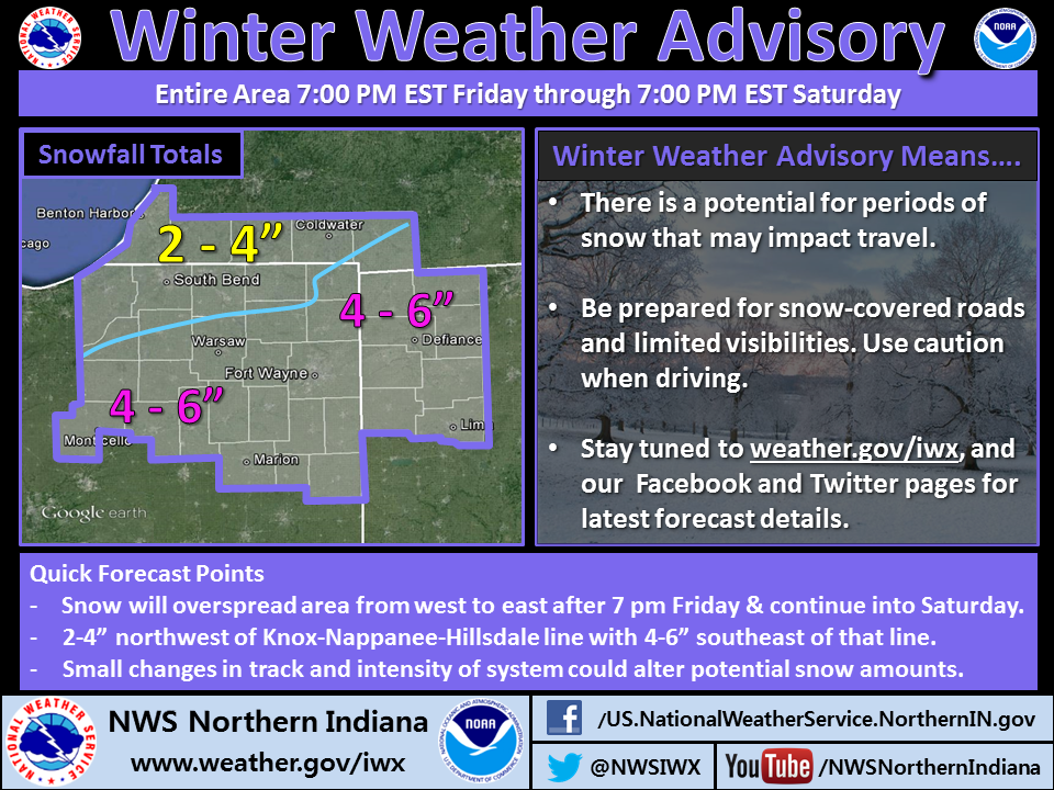
The northern Indiana office of he National Weather Service issued this infographic this evening.

The northern Indiana office of he National Weather Service issued this infographic this evening.
 |
| In this Jan. 10, 2002, file photo, a computer screen shows a password attack in progress at the Norwich University computer security training program in Northfield, Vt. (Photo: By Toby Talbot, AP) |
USA Today reported yesterday that almost 2 million accounts on Facebook, Google, Twitter, Yahoo and other social media and Internet sites have been breached. The hacking began Oct. 21 and might still be taking place, according to CNN.
In compiling data on the mass hacking, cyber-security company Trustwave discovered that many users are doing just what computer specialists advise against – using simplistic passwords that can easily be guessed.
For instance, the top five passwords Trustwave found in researching the breaches were: 123456, 123456789, 1234, password and 12345!
I bet some of those ridiculously insecure passwords were used by some otherwise very intelligent people, including ham radio operators and SKYWARN spotters.
I hope you are not one of them. But I know a lot of ham radio operators whose Yahoo accounts have been hacked over the past couple of years. How do I know? Because after the hacker took over, I got email from the hacked accounts.
So, even if you’ve chosen passwords for your Yahoo, Google, Facebook or other accounts that you think are more secure than “12345,” now would be a very good time to change to even more secure passwords.
Microsoft has a good Web page on how to create secure passwords. The page includes a link to a tool with which you can test your existing or potential passwords for strength.
You can also use an online password generator (like this one from computer security vendor Norton) to help you create a truly strong and random password.
Remember, the mass account hacking is probably still going on right now, so don’t wait. Improve your passwords today, before your Yahoo or Gmail account starts sending me spam!

Above is an infographic the northern Indiana office of the National Weather Service tweeted this morning. Below is a special weather statement it issued.
SPECIAL WEATHER STATEMENT
NATIONAL WEATHER SERVICE NORTHERN INDIANA
436 AM EST THU DEC 5 2013

INZ026-027-032>034-OHZ016-024-025-052000-
WELLS-ADAMS-GRANT-BLACKFORD-JAY-PUTNAM-VAN WERT-ALLEN OH-
INCLUDING THE CITIES OF...BLUFFTON...OSSIAN...DECATUR...BERNE...
MARION...GAS CITY...UPLAND...HARTFORD CITY...MONTPELIER...
PORTLAND...DUNKIRK...OTTAWA...PANDORA...KALIDA...FORT JENNINGS...
VAN WERT...DELPHOS...OHIO CITY...LIMA...SPENCERVILLE
436 AM EST THU DEC 5 2013

...ACCUMULATING SNOW POSSIBLE TONIGHT AND FRIDAY...

PERIODS OF SNOW...POTENTIALLY MIXED WITH SLEET AND RAIN EARLY
THIS EVENING...ARE EXPECTED TO DEVELOP OVERNIGHT AND INTO FRIDAY
AS TWO DISTURBANCES TRACK NORTHEAST ALONG A STRONG FRONTAL
BOUNDARY THAT WILL STALL OUT ACROSS THE OHIO VALLEY. CURRENT
EXPECTATIONS ARE FOR ONE BATCH OF PRECIPITATION TO MOVE THROUGH
TONIGHT WITH 1 TO 3 INCHES OF SNOW...MAINLY ALONG A LINE FROM
HARTFORD CITY TO LIMA. AN ADDITIONAL 1 TO 2 INCHES APPEARS
POSSIBLE FRIDAY AFTERNOON WITH A SECOND IMPULSE. IF YOU HAVE
TRAVEL PLANS...PLEASE KEEP ADVISED OF THE LATEST FORECASTS.
 |
| Operation Blessing photo |
Associated Churches Active in Disaster (ACAD, the disaster ministry of Associated Churches of Fort Wayne and Allen County) has learned of an opportunity for Christians to be part of the body of Christ serving the victims of the tornado disaster in Washington, Illinois.
Christian relief organization Operating Blessing, with which ACAD has a relationship, is on the ground in Washington and coordinating incoming volunteers daily except Sundays. Volunteers must be at least 18 years old, must provide their own transportation to the volunteer reception center in Peoria and from there to and from work sites and must provide their own lodging. Read more on the Operation Blessing Facebook page.
A member of the ACAD leadership team volunteered with Operation Blessing in Moore, Okla. last summer and found it to be a well-run operation.
Please share this information, and the information linked above, with members of your congregation and others who might wish to volunteer. Volunteers may travel to Illinois as individuals and/or they may travel together in mission teams.
For more information on this opportunity, please contact Operation Blessing directly at volunteer@ob.org or 757-226-3407.
 |
| NWS photo collage |
The northern Indiana office of the National Weather Service has updated its Web page on which it reports on the 15 tornadoes that struck northern Indiana, southern lower Michigan and northwestern Ohio Nov. 17. The updated Web page includes hyperlinks to a detailed page for each tornado along with individual path maps.
 |
| I&M crews replace several poles broken by the Nov. 17 severe thunderstorm. (Jay Farlow photo) |
I’m really impressed with the communications staff at Indiana and Michigan Power, the AEP branch that sells electricity in Fort Wayne, Indiana, where I live. Here’s why:
After the severe thunderstorms and tornadoes of Nov. 17 rolled through, thousands of I&M customers were without power, including our neighborhood. We live half a mile north of a stretch of road where the wind below down at least seven utility poles in a row.
I&M very effectively used its web site to provide regular updates on the situation. There, I could see estimates of when power would be restored in various locations, or if such estimates were not yet available, estimates of when the estimates would be available! The Web page also provided an explanation of the seriousness of the problem (e.g. the number of utility poles blown down) and information about the utility’s response, including the number of staff members and contractors who were working on service restoration.
I&M published on the same page the date and time of the current update, and the date and time to expect a new update. They updated the page frequently, even outside of business hours.
For me, however, the icing on the cake is this text, which appeared on the page today:
Additional Information
We will be flying Transmission lines in central & western Indiana to inspect the lines for vegetation resulting from the storm. I&M customers may see the helicopter in the Muncie and Fort Wayne areas. Tail Number N105JD Black with Grey Stripes in color.
Look at that! There’s no need for I&M customers who read that Web page to worry when the inspection helicopter flies by. Readers know exactly what to expect, right down to the helicopter’s tail number!
Any company, agency or organization that’s involved in any kind of public service and/or emergency response would do well to pay attention to how effectively I&M communicates information about major power outages. Clearly, I&M understands the value of keeping the public as informed as possible on a very regular basis.

Associated Churches Active in Disaster (ACAD, the disaster ministry of Associated Churches of Fort Wayne and Allen County) put out the following message on the Associated Churches Facebook Page this morning:
Regarding the tornado disaster in Kokomo and other parts of Indiana, Associated Churches Active in Disaster (ACAD) is in communication with Indiana Voluntary Organizations Active in Disaster (INVOAD), which will coordinate any volunteer response from outside the affected areas. During a conference call late yesterday afternoon, INVOAD indicated that no volunteer resources from outside the disaster areas are needed at this time.
The ACAD leadership team strongly recommends that well-meaning volunteers stay away from disaster areas until and unless they are part of a coordinated response. ACAD will remain in contact with those who are coordinating responses and will inform local Christians of response opportunities as they arise.
Please watch the Associated Churches Facebook page and Twitter feed for updated information.
Peace,
Dan Layden, ACAD Chair
Today the northern Indiana office of the National Weather Service (NWS) published the map below, which shows the tracks of the 13 tornadoes that touched down in the office’s coverage area. Note that the Kokomo tornado is not included, because Kokomo is in the coverage area of the Indianapolis NWS office.


This is not an optical illusion! The force of the tornado and debris mashed the railroad tracks together in Kokomo.

The American Red Cross of Northeastern Indiana just informed me that it closed its shelter at Bethlehem Lutheran church at 1 p.m. today. Apparently, no one made use of the shelter last night.
 Mike Seidel