Tag Archives: severe weather

Northern Indiana NWS office publishes weekend storm infographc

The warning coordination meteorologist at the northern Indiana National Weather Service forecast office, Michael Lewis, has advised that the office will continue to publish information like this on its website and Facebook page as a stormy Sunday approaches.

Lewis advises SKYWARN storm spotters to check communications tools now, to assure they’re working properly in advance of Sunday’s weather.

Slight risk of severe weather Sunday

The entire states of Indiana and Ohio, plus the southern half of lower Michigan are at slight risk of severe weather between 8 a.m. EST Sunday, Nov. 17 and 8 a.m. EST Monday, Nov. 18, according to a Day 3 Convective Outlook that the National Weather Service (NWS) Storm Prediction Center (SPC) issued at 3:30 a.m. EST today.

Forecasters say a deepening low pressure system will move northeastward from the upper Mississippi Valley into the Great Lakes region Sunday afternoon. A cold front will trail from the low, while a warm front lifts northward through the Ohio Valley and Great Lakes region.

The potential exists for storms ahead of the fronts to develop into supercells, but the extent of any tornado threat will depend on how much the atmosphere is able to destabilize, according to the convective outlook. And ongoing showers and cloud cover might limit that destabilization. Nonetheless, other storms will likely evolve into lines along the cold front and present a threat for widespread damaging straight-line wind.

SKYWARN storm spotters and others who are concerned about severe weather should be prepared to be aware of any storm watches or warnings that the NWS might issue Sunday. Our next look at the potential for severe weather will come with the SPC’s Day 2 Convective Outlook that’s due early Saturday morning.

Storms possible this weekend

Sunday’s Severe Storm Outlook

Just want to send out the “heads-up” that the Live Doppler 15 Fury Weather Team is currently monitoring the potential for severe storms on Sunday. Nothing’s set in stone yet and the overall severe chance remains low as of this post, but it does, indeed, exist as the weekend comes to a close.

Read more on Nicholas Ferreri’s WANE-TV weather blog.

Allen County cancels tornado siren test

Photograph of tornado siren

The tornado siren test that normally happens throughout Allen County, Indiana at noon on the first Wednesday of every month did not happen today. The Allen County Department of Homeland Security (DHS) notified the Allen County Amateur Radio Emergency Service (ARES) this morning that the county would not test sirens today.

ARES Emergency Coordinator Jim Moehring, KB9WWM, did not indicate in an email message why DHS canceled the test. The department, has, however, canceled tests in the past when the weather was rainy, out of fear that citizens might confuse the test with an actual tornado warning.

The National Weather Service activates weather alert radios every Wednesday morning for a weekly test and postpones the weekly test if there is a threat of severe weather on Wednesday. The NWS conducted its weekly test this morning, as usual.

Local NWS: Severe risk falls to near zero

The northern Indiana office of the National Weather Service issued an Areal Forecast Discussion at 4:58 p.m. EDT in which a forecaster writes that the potential for severe weather this evening appears “well in check and approaching zero, though never quite removed entirely.”

A narrow line of intense showers is forecast to move through this evening along an approaching cold front. The forecaster writes that line will bring a risk of strong wind gusts.

The forecaster also writes, however, that pervasive, sustained rainfall throughout the day has effectively stymied the development of thunderstorms along an approaching cold front.

Slight risk of severe weather remains in 4 p.m. update

A slight risk of severe weather continues for most of Indiana, extreme southern Michigan and most of Ohio, according to an updated Day 1 Convective Outlook that the National Weather Service (NWS) Storm Prediction Center issued at 4:02 p.m. EDT. The slight risk areas in the latest update are essentially the same as they were in the 9 a.m. update. The main difference is that extreme western and southwestern Indiana now have a slightly enhanced threat of a tornado.

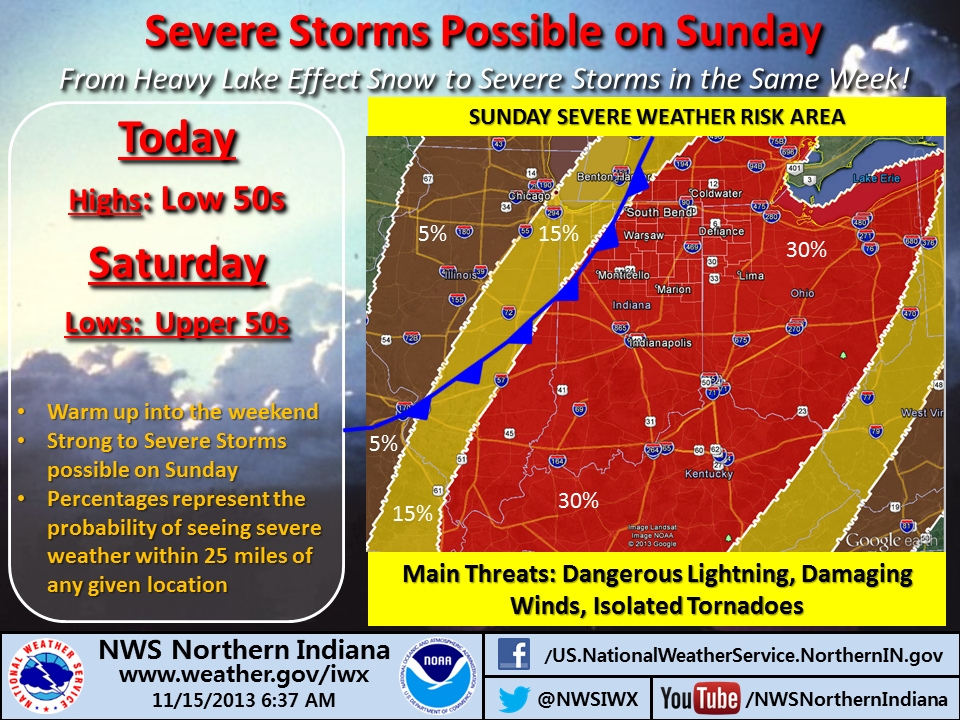
The northern Indiana NWS office indicated in an infographic a short while ago (see my earlier post) that any severe weather in northeastern Indiana and northwestern Ohio is not expected to occur before 10 p.m.

In addition, in an email sent to SKYWARN storm spotters at 12:13 p.m. EDT, NWS Warning Coordination Meteorologist Michael Lewis wrote that the day’s steady rainfall had greatly reduced the risk of severe weather but that isolated severe thunderstorms remained possible along and slightly ahead of an approaching cold front. The most likely severe threat is wind gusts of 55 mph to 60 mph. Forecaster expect no hail.

The area of greatest threat is along, south and east of U.S. 24.

Lewis said the following storm impacts are possible; branches down, weakened and dead trees down, and scattered power outages. Also, damage to weak and compromised buildings and other structures is possible.

There’s also a flooding threat. Additional rainfall amounts through midnight of one to two inches (with isolated higher amounts with thunderstorms) are possible. Significant leaf fall has caused drain blockages and subsequent street flooding.

NWS issues advisory for SKYWARN storm spotters

At 10:12 a.m. EDT, Michael Lewis, warning coordination meteorologist at the northern Indiana National Weather Service office, issued the following advisory to trained SKYWARN storm spotters:

From: Michael Lewis
Sent: Thursday, October 31, 2013 10:12 AM
Subject: Weather Information – 10/31/2013

Severe weather in Northern Indiana/Southern Lower Michigan and Northwest Ohio is not limited to the Spring.  September-November is another peak period for severe weather.

We are currently assessing the latest model data concerning the potential for severe weather today.

We will post our assessment as soon as we have a better idea of timing, duration and intensity.   It is hoped to have this posted before noon today.

In the meantime, the NWS in Northern Indiana continues to monitor Social Media (Facebook and Twitter)

All spotters are encouraged to review the reporting requirements and communications methods. 

Skywarn Spotter Resource Page:
http://www.crh.noaa.gov/iwx/?n=nwsnorthernindianaskywarnpage#Downloads

======================================================
Northern Indiana continually monitors:

* Social Media – (Facebook / Twitter)

* e-mail (w-iwx.webmaster@noaa.gov)

Webpages of interest:
https://nwschat.weather.gov/live
http://www.crh.noaa.gov/iwx/?n=embrief
http://preview.weather.gov/edd/
http://www.crh.noaa.gov/iwx/?n=nwsnorthernindianaskywarnpage

Severe weather risk doesn’t affect official trick-or-treating hours

Seal of the City of Fort Wayne

The mayor and police chief of the City of Fort Wayne issued a statement this morning that official trick-or-treating hours in the city will remain 6 p.m. to 8 p.m. EDT this evening, despite the risk of severe weather today.

The statement reads, in part, “Though we received some inquiries into the rescheduling of Trick-or-Treating due to the weather forecast, it was decided that because of several area events already scheduled for Friday evening, the move would create a burden for many families.”

Read the entire statement.

Tornadoes always possible in late fall

Photo of damaged cinema from 2002 tornado in Van Wert, Ohio
Van Wert cinema destroyed by November 10, 2002 tornado. (From NWS website).

While spring is the main season for tornadoes, don’t rule them out in late fall. You can bet the people of Van Wert, Ohio won’t. An F4 tornado hit that city on November 10, 2002. The same day, an F3 tornado touched down near Berne, Indiana, an F1 hit Hartford city and an F0 touched down near the southeastern Wells County village of Petroleum. Read more about the November 10, 2002 outbreak.

So, are we in for another day like November 10, 2002, today? Probably not, according to meteorologists at the northern Indiana office of the National Weather Service. The amount of atmospheric instability forecast for today is significantly less and more conditional than it was for the 2002 outbreak. In addition, several other meteorological metrics are below the levels seen in 2002.