

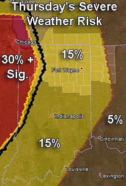
Probabilities of severe weather within 25 miles of any point between 8 a.m. Thurs., Apr. 9 and 8 a.m. Fri., Apr. 10. The thick black line encloses and area that has a 10 percent or greater probability of significant severe weather during the period (see blog text for definition). Highlighted counties: County warning area of the northern Indiana NWS office. Source: SPC “Day 3 Convective Outlook” issued at X:XX a.m. EDT