URGENT - WINTER WEATHER MESSAGE
NATIONAL WEATHER SERVICE NORTHERN INDIANA
1138 AM EST FRI DEC 13 2013

.SIGNIFICANT SNOW ACCUMULATIONS ARE EXPECTED OVER THE AREA TONIGHT
AND SATURDAY AS A LOW PRESSURE SYSTEM MOVES FROM THE SOUTHERN
PLAINS THROUGH THE OHIO VALLEY. SNOW IS EXPECTED TO OVERSPREAD THE
AREA FROM SOUTHWEST TO NORTHEAST THIS EVENING AND OVERNIGHT...AND
THEN END FROM WEST TO EAST DURING THE AFTERNOON HOURS ON SATURDAY.

ACCUMULATIONS TONIGHT AND SATURDAY ARE EXPECTED TO RANGE FROM 5 TO
8 INCHES ACROSS THE WARNING AREA...ROUGHLY SOUTH OF A LINE FROM
KNOX TO AUBURN INDIANA AND WAUSEON OHIO. ACCUMULATIONS OF 3 TO 6 INCHES
ARE EXPECTED NORTH OF THIS LINE IN THE ADVISORY AREA.


INZ008-009-012>018-020-022>027-032>034-OHZ001-002-004-005-015-016-
024-025-140045-
/O.UPG.KIWX.WW.Y.0012.131214T0000Z-131215T0000Z/
/O.NEW.KIWX.WS.W.0003.131214T0000Z-131215T0000Z/
NOBLE-DE KALB-STARKE-PULASKI-MARSHALL-FULTON IN-KOSCIUSKO-WHITLEY-
ALLEN IN-WHITE-CASS IN-MIAMI-WABASH-HUNTINGTON-WELLS-ADAMS-GRANT-
BLACKFORD-JAY-WILLIAMS-FULTON OH-DEFIANCE-HENRY-PAULDING-PUTNAM-
VAN WERT-ALLEN OH-
INCLUDING THE CITIES OF...KENDALLVILLE...LIGONIER...ALBION...
AUBURN...GARRETT...KNOX...NORTH JUDSON...BASS LAKE...WINAMAC...
FRANCESVILLE...MEDARYVILLE...PLYMOUTH...BREMEN...CULVER...
ROCHESTER...AKRON...WARSAW...WINONA LAKE...SYRACUSE...MENTONE...
COLUMBIA CITY...TRI-LAKES...SOUTH WHITLEY...FORT WAYNE...
NEW HAVEN...MONTICELLO...BROOKSTON...MONON...LOGANSPORT...
ROYAL CENTER...PERU...GRISSOM AFB...MEXICO...WABASH...
NORTH MANCHESTER...HUNTINGTON...ROANOKE...BLUFFTON...OSSIAN...
DECATUR...BERNE...MARION...GAS CITY...UPLAND...HARTFORD CITY...
MONTPELIER...PORTLAND...DUNKIRK...BRYAN...WAUSEON...ARCHBOLD...
FAYETTE...SWANTON...DEFIANCE...SHERWOOD...HICKSVILLE...NAPOLEON...
DESHLER...LIBERTY CENTER...PAULDING...ANTWERP...MELROSE...
OTTAWA...PANDORA...KALIDA...FORT JENNINGS...VAN WERT...DELPHOS...
OHIO CITY...LIMA...SPENCERVILLE
1138 AM EST FRI DEC 13 2013 /1038 AM CST FRI DEC 13 2013/

...WINTER STORM WARNING IN EFFECT FROM 7 PM EST /6 PM CST/ THIS
EVENING TO 7 PM EST /6 PM CST/ SATURDAY...

THE NATIONAL WEATHER SERVICE IN NORTHERN INDIANA HAS ISSUED A
WINTER STORM WARNING FOR HEAVY SNOW...WHICH IS IN EFFECT FROM 7
PM EST /6 PM CST/ THIS EVENING TO 7 PM EST /6 PM CST/ SATURDAY.
THE WINTER WEATHER ADVISORY IS NO LONGER IN EFFECT.

HAZARDOUS WEATHER...

 * SNOW WILL OVERSPREAD THE AREA FROM SOUTHWEST TO NORTHEAST THIS
   EVENING...BECOMING HEAVY AT TIMES OVERNIGHT THROUGH EARLY SATURDAY
   AFTERNOON.

 * TOTAL ACCUMULATIONS OF 5 TO 8 INCHES ARE EXPECTED BY EARLY
   SATURDAY EVENING WITH LOCALLY HIGHER AMOUNTS POSSIBLE. AT THIS
   TIME...THE HIGHEST AMOUNTS ARE EXPECTED NEAR OR SOUTH OF US
   ROUTE 6 ACROSS INDIANA AND NORTHWEST OHIO.

IMPACTS...

 * ROADS WILL BECOME SNOW COVERED...SLICK AND HAZARDOUS TONIGHT...
   CONTINUING INTO SATURDAY. THIS WILL MAKE TRAVEL DANGEROUS
   ACROSS THE WARNING AREA.

 * VISIBILITIES WILL BE REDUCED TO LESS THAN ONE QUARTER MILE WITH
   THE HEAVY SNOW.

 * USE CAUTION WHEN SHOVELING SNOW AS THIS CAN BE A VERY STRENUOUS
   ACTIVITY.


PRECAUTIONARY/PREPAREDNESS ACTIONS...


A WINTER STORM WARNING FOR HEAVY SNOW MEANS SEVERE WINTER WEATHER
CONDITIONS ARE EXPECTED OR OCCURRING.  SIGNIFICANT AMOUNTS OF
SNOW ARE FORECAST THAT WILL MAKE TRAVEL DANGEROUS. ONLY TRAVEL IN
AN EMERGENCY. IF YOU MUST TRAVEL...KEEP AN EXTRA FLASHLIGHT...
FOOD...AND WATER IN YOUR VEHICLE IN CASE OF AN EMERGENCY.
Category Archives: SKYWARN
Significant snowfall early this weekend
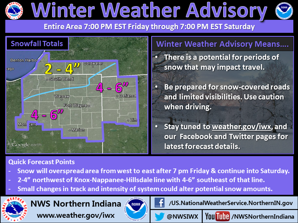
The northern Indiana office of the National Weather Service issued the above infographic at 4:45 a.m. today, to update expected accumulation from the coming snow event. At about the same time, the office issued the updated winter weather advisory below.
URGENT - WINTER WEATHER MESSAGE
NATIONAL WEATHER SERVICE NORTHERN INDIANA
409 AM EST FRI DEC 13 2013

.SIGNIFICANT SNOW ACCUMULATIONS ARE EXPECTED OVER THE AREA FRIDAY
NIGHT AND SATURDAY AS A LOW PRESSURE SYSTEM MOVES FROM THE
SOUTHERN PLAINS THROUGH THE OHIO VALLEY. SNOW IS EXPECTED TO
OVERSPREAD THE AREA FROM SOUTHWEST TO NORTHEAST FRIDAY NIGHT...
AND THEN END FROM WEST TO EAST DURING THE AFTERNOON HOURS OF
SATURDAY. ACCUMULATIONS FRIDAY NIGHT AND SATURDAY ARE EXPECTED TO
RANGE FROM 3 TO 5 INCHES OVER NORTHWEST PORTIONS OF OUR AREA...
TO 5 TO 8 INCHES SOUTHEAST. SOME POST-STORM LAKE EFFECT SNOW IS
POSSIBLE OVER NORTHWEST PORTIONS OF THE AREA ON SATURDAY NIGHT AND
SUNDAY AS WINDS SHIFT TO NORTHWEST AND COLDER AIR OVERSPREADS THE
AREA.

INZ007>009-012>018-020-022>027-032>034-MIZ081-OHZ001-002-004-005-
015-016-024-025-131715-
/O.CON.KIWX.WW.Y.0012.131214T0000Z-131215T0000Z/
STEUBEN-NOBLE-DE KALB-STARKE-PULASKI-MARSHALL-FULTON IN-KOSCIUSKO-
WHITLEY-ALLEN IN-WHITE-CASS IN-MIAMI-WABASH-HUNTINGTON-WELLS-
ADAMS-GRANT-BLACKFORD-JAY-HILLSDALE-WILLIAMS-FULTON OH-DEFIANCE-
HENRY-PAULDING-PUTNAM-VAN WERT-ALLEN OH-
INCLUDING THE CITIES OF...ANGOLA...FREMONT...KENDALLVILLE...
LIGONIER...ALBION...AUBURN...GARRETT...KNOX...NORTH JUDSON...
BASS LAKE...WINAMAC...FRANCESVILLE...MEDARYVILLE...PLYMOUTH...
BREMEN...CULVER...ROCHESTER...AKRON...WARSAW...WINONA LAKE...
SYRACUSE...MENTONE...COLUMBIA CITY...TRI-LAKES...SOUTH WHITLEY...
FORT WAYNE...NEW HAVEN...MONTICELLO...BROOKSTON...MONON...
LOGANSPORT...ROYAL CENTER...PERU...GRISSOM AFB...MEXICO...
WABASH...NORTH MANCHESTER...HUNTINGTON...ROANOKE...BLUFFTON...
OSSIAN...DECATUR...BERNE...MARION...GAS CITY...UPLAND...
HARTFORD CITY...MONTPELIER...PORTLAND...DUNKIRK...HILLSDALE...
LITCHFIELD...JONESVILLE...BRYAN...WAUSEON...ARCHBOLD...FAYETTE...
SWANTON...DEFIANCE...SHERWOOD...HICKSVILLE...NAPOLEON...DESHLER...
LIBERTY CENTER...PAULDING...ANTWERP...MELROSE...OTTAWA...
PANDORA...KALIDA...FORT JENNINGS...VAN WERT...DELPHOS...
OHIO CITY...LIMA...SPENCERVILLE
409 AM EST FRI DEC 13 2013 /309 AM CST FRI DEC 13 2013/

...WINTER WEATHER ADVISORY REMAINS IN EFFECT FROM 7 PM EST /6 PM
CST/ THIS EVENING TO 7 PM EST /6 PM CST/ SATURDAY...

HAZARDOUS WEATHER...

 * SNOW IS EXPECTED TO OVERSPREAD THE AREA FROM WEST TO EAST
   FRIDAY NIGHT. TOTAL ACCUMULATIONS ARE EXPECTED TO BE 5 TO 8
   INCHES BY EARLY SATURDAY EVENING WITH LOCALLY HIGHER AMOUNTS
   POSSIBLE. AT THIS TIME...THE HIGHEST AMOUNTS ARE EXPECTED
   ALONG AND SOUTH OF ROUTE 24.

IMPACTS...

 * ROADS WILL BECOME SNOW COVERED... SLICK AND HAZARDOUS FRIDAY
   NIGHT... CONTINUING INTO SATURDAY... MAKING TRAVEL ACROSS THE
   AREA DIFFICULT.

 * USE CAUTION WHEN SHOVELING SNOW AS THIS CAN BE A VERY
   STRENUOUS ACTIVITY.

PRECAUTIONARY/PREPAREDNESS ACTIONS...

A WINTER WEATHER ADVISORY FOR SNOW MEANS THAT PERIODS OF SNOW
WILL CAUSE PRIMARILY TRAVEL DIFFICULTIES. BE PREPARED FOR SNOW
COVERED ROADS AND LIMITED VISIBILITIES...AND USE CAUTION WHILE
DRIVING.
Winter weather advisory issued
Accumlating snow expected in central, southern Indiana
Above is an infographic the northern Indiana office of the National Weather Service tweeted this morning. Below is a special weather statement it issued.
SPECIAL WEATHER STATEMENT
NATIONAL WEATHER SERVICE NORTHERN INDIANA
436 AM EST THU DEC 5 2013

INZ026-027-032>034-OHZ016-024-025-052000-
WELLS-ADAMS-GRANT-BLACKFORD-JAY-PUTNAM-VAN WERT-ALLEN OH-
INCLUDING THE CITIES OF...BLUFFTON...OSSIAN...DECATUR...BERNE...
MARION...GAS CITY...UPLAND...HARTFORD CITY...MONTPELIER...
PORTLAND...DUNKIRK...OTTAWA...PANDORA...KALIDA...FORT JENNINGS...
VAN WERT...DELPHOS...OHIO CITY...LIMA...SPENCERVILLE
436 AM EST THU DEC 5 2013

...ACCUMULATING SNOW POSSIBLE TONIGHT AND FRIDAY...

PERIODS OF SNOW...POTENTIALLY MIXED WITH SLEET AND RAIN EARLY
THIS EVENING...ARE EXPECTED TO DEVELOP OVERNIGHT AND INTO FRIDAY
AS TWO DISTURBANCES TRACK NORTHEAST ALONG A STRONG FRONTAL
BOUNDARY THAT WILL STALL OUT ACROSS THE OHIO VALLEY. CURRENT
EXPECTATIONS ARE FOR ONE BATCH OF PRECIPITATION TO MOVE THROUGH
TONIGHT WITH 1 TO 3 INCHES OF SNOW...MAINLY ALONG A LINE FROM
HARTFORD CITY TO LIMA. AN ADDITIONAL 1 TO 2 INCHES APPEARS
POSSIBLE FRIDAY AFTERNOON WITH A SECOND IMPULSE. IF YOU HAVE
TRAVEL PLANS...PLEASE KEEP ADVISED OF THE LATEST FORECASTS.
NWS northern Indiana updates report on Nov. 17 tornadoes
 |
| NWS photo collage |
The northern Indiana office of the National Weather Service has updated its Web page on which it reports on the 15 tornadoes that struck northern Indiana, southern lower Michigan and northwestern Ohio Nov. 17. The updated Web page includes hyperlinks to a detailed page for each tornado along with individual path maps.
Indiana & Michigan Power gets post-storm communication right
 |
| I&M crews replace several poles broken by the Nov. 17 severe thunderstorm. (Jay Farlow photo) |
I’m really impressed with the communications staff at Indiana and Michigan Power, the AEP branch that sells electricity in Fort Wayne, Indiana, where I live. Here’s why:
After the severe thunderstorms and tornadoes of Nov. 17 rolled through, thousands of I&M customers were without power, including our neighborhood. We live half a mile north of a stretch of road where the wind below down at least seven utility poles in a row.
I&M very effectively used its web site to provide regular updates on the situation. There, I could see estimates of when power would be restored in various locations, or if such estimates were not yet available, estimates of when the estimates would be available! The Web page also provided an explanation of the seriousness of the problem (e.g. the number of utility poles blown down) and information about the utility’s response, including the number of staff members and contractors who were working on service restoration.
I&M published on the same page the date and time of the current update, and the date and time to expect a new update. They updated the page frequently, even outside of business hours.
For me, however, the icing on the cake is this text, which appeared on the page today:
Additional Information
We will be flying Transmission lines in central & western Indiana to inspect the lines for vegetation resulting from the storm. I&M customers may see the helicopter in the Muncie and Fort Wayne areas. Tail Number N105JD Black with Grey Stripes in color.
Look at that! There’s no need for I&M customers who read that Web page to worry when the inspection helicopter flies by. Readers know exactly what to expect, right down to the helicopter’s tail number!
Any company, agency or organization that’s involved in any kind of public service and/or emergency response would do well to pay attention to how effectively I&M communicates information about major power outages. Clearly, I&M understands the value of keeping the public as informed as possible on a very regular basis.
Northern Indiana NWS publishes tornado track map
Today the northern Indiana office of the National Weather Service (NWS) published the map below, which shows the tracks of the 13 tornadoes that touched down in the office’s coverage area. Note that the Kokomo tornado is not included, because Kokomo is in the coverage area of the Indianapolis NWS office.
Tornado bends railroad tracks in Kokomo
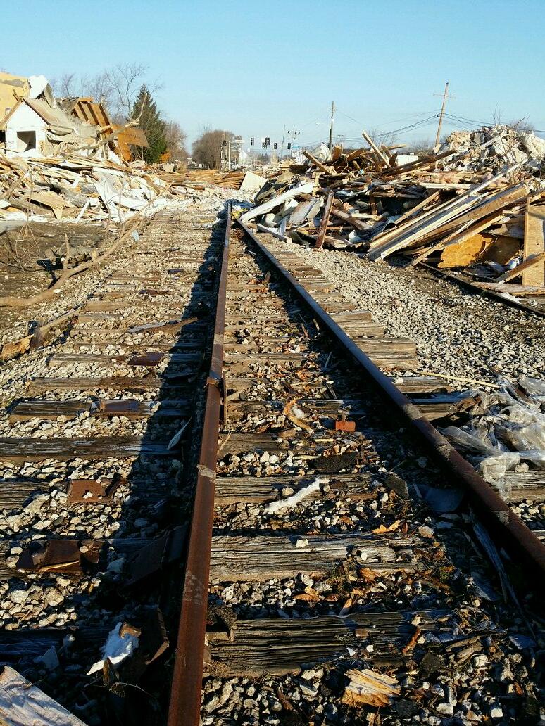
This is not an optical illusion! The force of the tornado and debris mashed the railroad tracks together in Kokomo.
Lessons in Emergency Social Media Communications from the National Weather Service
47 of the top 50 tweets sent by federal government Twitter accounts yesterday (Nov. 18) were warnings from various National Weather Service (NWS) offices on the severe weather impacting the Midwest. …
There are two quick lessons we can take from NWS’s tweets yesterday.
Decatur, Indiana: Severe thunderstorm leads to … gas main break?
 |
| WANE-TV photo |
“If it’s not one thing, it’s another.”
Reports indicate that electric utility crews in Decatur, Indiana were digging a hole to plant a pole to replace one broken by Sunday’s storm when … they hit a 4-inch gas main.
According to this report from WANE-TV, the gas leak forced Decatur officials to close U.S. 27 (the city’s main thoroughfare) and evacuate about 50 homes.
As if storm damage and power outages weren’t enough!


 Mike Seidel