All posts by Jay Farlow

I'm Jay Farlow. W9LW is my amateur (ham) radio call sign. I've been a ham since 1973. I've been a volunteer storm spotter for the National Weather Service SKYWARN program since the 1970s. I've also been a volunteer EMT and firefighter and member of a disaster medical assistance team. I advise the leadership team of Associated Churches Active in Disaster, a ministry of Associate Churches of Fort Wayne and Allen County. Learn more about w9lw at www.qrz.com/db/w9lw.

Slight risk of severe storms tomorrow evening in central and southern Indiana

Day 2 convective outlook map

Much of central and southern Indiana continues to be have a slight risk of severe thunderstorms tomorrow, according to the Day 2 Convective Outlook that the National Weather Service Storm Prediction Center issued at 1:49 a.m. today. The greatest risks are for damaging straight-line wind gusts and severe hail produced by lines of storms in the late afternoon and early evening tomorrow.

As you can see on the map above right, the slight risk area includes most of the western half of Indiana, with the exception of some northern counties. The slight risk area includes the cities of Logansport, Marion, Kokomo, Lafayette, Indianapolis, Terre Haute, Bloomington, Evansville and others. Its northern edge includes all or significant parts of the following counties: Benton, White, Cass, southern Miami, southern Wabash and extreme southwestern Huntington.

The SPC will update its day two outlook for this period by 1:30 p.m. EDT. After that, our next outlook for Friday will arrive with the first day one outlook at around 1 a.m.

Meanwhile, northern Iowa and southern Minnesota is in a bull’s eye for severe weather today, where the SPC is forecasting supercell thunderstorms this afternoon. Forecasters expect tornadoes — some of which could be strong — as well as large, damaging hail and sporadic severe straight-line wind gusts in that area. This moderate risk area for today runs from just south of Minneapolis south to and including Des Moines.

Slight risk of severe weather in central Indiana Friday

Yellow area: Slight risk of severe thunderstorms Friday, including hail and damaging straight-line winds. Green area: Thunderstorms but insignificant risk of severe thunderstorms.

Portions of central Indiana have a slight risk of severe weather between 8 a.m. EDT Friday and 8 a.m. EDT Saturday, according to a Day 3 Convective Outlook that the National Weather Service Storm Prediction Center (SPC) issued at 3:20 a.m. EDT today. Hail and damaging straight-line winds are the greatest threats and these are most likely Friday evening.

As you can see on the map above, the slight risk area includes the following Indiana counties and other counties to the south and west of them: Benton, White, Cass, southern Miami, southern Wabash, southwestern  Huntington and Grant.

Because this forecast is for more than 48 hours form now, there is some uncertainty regarding where severe weather might form. Our next look at the risks of severe weather will come with the Day 2 Convective Outlook that the SPC will issue at around 2 a.m. EDT tomorrow.

Miss. residents learn the hard way not to rely on tornado sirens

People in Tupelo, Miss. are up in arms about the fact that they didn’t hear tornado sirens when a an EF-3 tornado hit that town Monday, April 28. As a news story on a TV station’s website indicates, there’s some controversy over whether the siren system worked right.

One of the best quotes in that story comes from Mississippi State Climatologist Michael Brown: “Tupelo learned a good lesson – that you shouldn’t rely on sirens.”

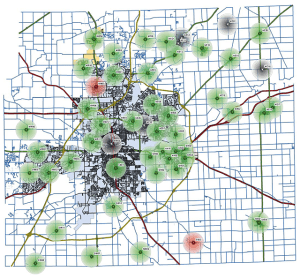
As frequent readers of this blog know, I’ve been beating that drum as well. Today, I found a PDF file online that shows graphically how much of Fort Wayne and Allen County, Indiana are not covered by tornado sirens. These dead spots are places where you might not to hear a siren, even if you’re outdoors and even if all the sirens activate properly. A reduced version of that map appears below.

So, don’t rely on tornado sirens. A tornado could be bearing down on your house and you might never hear a siren. There are plenty of other ways to be warned and I think the best is a weather alert radio. These devices are available at a discount right now at several retail stores in the Fort Wayne area, including Walgreens. If you don’t have one, get one. Program it to remain silent unless a warning includes your county. Put it someplace in your house where it will wake you if an alert goes out. Put fresh batteries in it every six months, so it will wake you even if a storm takes out your power. And above all,
stop relying on outdoor warning sirens!
If you have friends or family members who don’t yet have a weather alert radio, please use the sharing buttons below to share this post via Facebook, Twitter, etc.

Allen County, Indiana outdoor warning siren coverage map
Outdoor warning siren coverage map for Allen County, Indiana (see a full-size map as a PDF file). If you are not in one of the colored circles, you might not hear anything when the county activates the siren system. Even inside a circle, you might not hear a siren unless you are outdoors. That’s why you must have another means of knowing about weather dangers.

Benign cold-air funnel clouds possible today

Photo of cold air funnel
Photo from NWS website

Meteorologists expressed a growing concern for cold-air funnel clouds this afternoon, in an area forecast discussion (AFD) the northern Indiana National Weather Service (NWS) office issued at 10:34 a.m. EDT. As always, the chances of any such funnels reaching the ground are very small, but they can cause concern among the untrained public. Read more about cold air funnels on the website of the Wilimington, Ohio NWS office.

Meanwhile, the AFD indicates that meteorologists continue to expect a short-lived severe weather threat from 5 p.m. and 9 p.m. EDT today, especially in the eastern half of the 37-county area covered by the northern Indiana NWS office (see map below). Straight-line winds will be the primary threat. Small hail is likely, but atmospheric instability is weak, so the threat of hail reaching severe criteria is very limited.

northern Indiana NWS forecast area map
Light-colored area: Forecast area of northern Indiana NWS office.

An isolated supercell thunderstorm is possible in the southeastern portion of the northern Indiana NWS office’s forecast area (e.g. Blackford, Jay and Adams Counties in Indiana and Van Wert and Allen Counties in Ohio). If such a storm forms, it would increase the risk of large hail and could create a brief threat of a tornado. But the threat of a supercell depends on sufficient atmospheric instability occurring.

Isolated severe thunderstorms possible this afternoon and evening

Yellow area: Slight risk of severe weather between 9 a.m. EDT today and 8 a.m. EDT Wednesday. Red area: moderate risk of severe weather during same period.

Almost all of Indiana, the southern half of Lower Michigan and all of Ohio have a slight risk for severe thunderstorms this afternoon and evening, according to the Day 1 Convective Outlook that the National Weather Service Storm (NWS) Prediction Center issued at 8:45 a.m. EDT. The main threats are large hail and damaging straight-line winds. The NWS might need to activate SKYWARN storm spotters this afternoon into this evening, according to the Hazardous Weather Outlook the northern Indiana NWS office issued at 4:47 a.m. EDT.

Risks
In the “slight risk” areas of Indiana, Michigan and Ohio (see map, above right), the convective outlook indicates a 15 percent probability of damaging thunderstorm winds of 50 knots (58 mph) or greater within 25 miles of a point. The outlook indicates the same probability of one-inch diameter or larger hail. The probability of a tornado in these areas is negligible at two percent or less. To understand these probabilities, remember how often 58 mph winds do damage or one-inch hail falls within 25 miles of your home. The normal probability of such phenomena is probably less than one percent, so today’s probability is at least 15 times greater than normal. Read more about the outlook probabilities.

Actions to take
Make sure your weather alert radio is plugged in and working and that you’ll hear it if the NWS issues a severe thunderstorm watch or warning today. During any times you won’t be near a weather alert radio, make sure you have other ways to receive such information, including keeping a broadcast radio or television on or signing up for text alerts from your favorite local TV station. Above all, don’t ignore a severe thunderstorm warning. Remember how much damage a severe thunderstorm did in the Fort Wayne area in June of 2012, when the now-famous “derecho” came through. Severe thunderstorms can do a lot of dangerous damage, even when they do not produce tornadoes!

If you’re a SKYWARN storm spotter, gas up your car, check your communications gear and review NWS reporting criteria, as you might need them this afternoon and evening.

Meteorological setup
Afternoon showers and thunderstorms are forecast to develop across the mid-Ohio Valley and northwestward into Lower Michigan, as the left exit region of a 120-plus knot jet stream rounds the southeast side of an upper low and spreads across the region. With 500 to 1000 joules per kilogram of relatively low-topped mixed-layer convective available potential energy forecast to develop, isolated severe storms are expected — with organization potential enhanced by strong flow through the mid and upper troposphere. Along with a risk for hail, locally damaging winds can be expected through early evening — after which a diminishing trend is expected in conjunction with the boundary-layer stabilization that happens every evening.

Mississippi, Alabama again targeted
Elsewhere, Mississippi and Alabama, which were clobbered by tornadoes yesterday, are again in the cross hairs today. Parts of both states have a 15 percent risk of tornadoes this afternoon and evening.

SPC updates Tuesday severe risk scenario

Day 2 convective outlook map
Risk of severe weather between 8 a.m. EDT Tuesday and 8 a.m. EDT Wednesday. Yellow area: Slight risk. Green area: Non-severe thunderstorms.

Much of eastern Indiana and almost all of Ohio remains under a slight risk of severe weather from 8 a.m. EDT Tuesday to 8 a.m. EDT Wednesday, according to an updated Day 2 Convective Outlook the National Weather Service Storm Prediction Center (SPC) issued at 1:29 p.m. EDT.

Tomorrow afternoon, some surface heating in the wake of thunderstorms earlier in the day should provide sufficient buoyancy for isolated severe storms with damaging winds and severe hail. Some tornado risk might evolve from parts of middle Tennessee to the Ohio valley and possibly Lower Michigan, but this will be contingent on more appreciable daytime atmospheric destabilization, for which uncertainty remains.

Our next look at tomorrow’s serve weather risk will come at about 2 a.m. EDT tomorrow, when the SPC issues its first Day 1 Convective Outlook for the period.

Rain diminishes today’s severe threat for northern Indiana

The northern Indiana office of the National Weather Service issued a tweet this afternoon that indicates severe weather has ceased to be an issue today in any of the 37 counties in its county warning area (see map below). Here’s the tweet:

This morning’s rain has stabilized the atmosphere locally. Severe weather threat for remainder of day expected to remain S of the area
— NWS Northern Indiana (@NWSIWX) April 28, 2014

IWX county warning area map

Hail risk in west-central Indiana decreases

No part of Indiana has more than a 15 percent risk of one inch diameter or larger hail within 25 miles of a point, according to the updated Day 1 Convective Outlook that the National Weather Service Storm Prediction Center (SPC) issued at 12:46 p.m. EDT. An earlier version of the outlook indicated a 30 percent probability of severe hail in a few extreme west-central Indiana counties.

As of the latest outlook, approximately the southern two thirds of Indiana remained at slight risk of severe weather until 8 a.m. EDT Tuesday, with 15 percent probabilities of severe hail or damaging thunderstorm winds within 25 miles of a point. The probability of a tornado in Indiana during the same period is two percent or less.

Meanwhile, parts of Tennessee, Mississippi and Alabama remain at moderate risk of a tornado today, including a risk of a “significant” tornado (one capable of creating EF2 to EF5 damage).

The SPC will issue its next update to the convective outlook for today by 4 p.m. EDT.

Slight risk of severe storms in Indiana today and tomorrow

Day 1 convective outlook map
Risks of severe weather between 8 a.m. EDT today and 8 a.m. EDT Tuesday. Yellow area: slight risk. Red area: moderate risk.

Much of Indiana has a slight risk of severe storms between 8 a.m. EDT today and 8 a.m. EDT tomorrow, according to a Day 1 Convective Outlook the National Weather Service Storm Prediction Center (SPC) issued at 8:37 a.m. EDT. In addition, much of the eastern half of Indiana has a slight risk of severe weather during the  subsequent 24-hour period, between 8 a.m. EDT Tuesday and 8 a.m. EDT Wednesday, according to this morning Day 2 Convective Outlook.

Area covered today
As you can see on the map graphic at right, The northern edge of today’s slight risk area includes all or parts (at least half) of the following Indiana counties: Jasper, White, Cass, Howard, Grant, Delaware and Randolph. Indiana counties to the north of these are either not included or only small parts are included. Today’s slight risk area includes all Indiana counties to the south of the counties listed above. In Ohio, today’s slight risk area includes Darke, Miami, Clark and Greene Counties and other counties to the south of those.

Today’s risks
The main severe weather risks in Indiana today and tonight are damaging thunderstorm winds or wind gusts of 50 knots (58 mph) or higher and one inch diameter or larger hail. The probability of either of those within 25 miles of a point is 15 percent, except for a few counties in west central Indiana, where the hail risk reaches 30 percent.

Timing
A band of showers and low-topped thunderstorms are forecast to develop during the afternoon today in the vicinity of eastern Iowa and western Illinois. Those storms will move east and are forecast to weaken at around sunset.

Tomorrow
This morning’s Day 2 Convective Outlook puts all but the easternmost counties of Ohio and much of eastern Indiana under slight risk of severe weather between 8 a.m. EDT Tuesday and 8 a.m. EDT Wednesday. Indiana Counties at last half of which are covered include: Steuben, DeKalb, Whitley, Allen, Huntington, Adams, Wells, Grant, Blackford, Jay and counties to the south of these, all the way to Louisville and Cincinnati. The probability of any kind of severe weather within 25 miles of a point is 15 percent. The greatest risk for severe weather during this period will be Tuesday afternoon through early evening.

Next looks
The SPC will issue an updated Day 1 Convective Outlook by 12:30 p.m. EDT. The next look at Tuesday’s severe weather risk comes in an updated Day 2 Convective Outlook by 1:30 p.m.

Elsewhere
If you have family in Tennessee, Mississippi or Alabama, you’ll want to know that there’s a moderate risk of tornadoes in parts of those states today, including tornadoes capable of producing up to EF5 damage. Its particularly important for people in those areas to remain aware of the weather situation today.