The National Weather Service (NWS) is developing a web application that displays radar data and other information on a map. The Enhanced Data Display (EDD) can be a useful tool for SKYWARN storm spotters, especially those who do not have a radar program like Gibson Ridge’s GRLevel3.
EDD can display standard radar base reflectivity data (that common radar image that shows where the rain is and how heavy it is). It can also show velocity products, that show potential rotation in storms.
EDD can also geographically display a large number of NWS products, including convective outlooks, mesoscale discussions, watches and warnings. Once you display any of these products, you can zoom in to specific areas of interest. This can be useful, for example, if you want to learn whether your home is under a level 1 (marginal) or level 2 (slight) risk in a convective outlook, or whether your home is inside or outside a tornado warning polygon.
You can also optionally choose to add layers for features such as county lines, NWS county warning area lines, etc.
Although the application is officially still experimental (which means it might not always work as expected), it’s open to the public and available for you to try. I recommend playing around with it to see how it could help you with your situational awareness.
SKYWARN storm spotters and future spotters prepare for training Feb. 16, 2016 at the Public Safety Academy of Northeast Indiana, Fort Wayne
The husband-and-wife team of Amos and Megan Dodson, both meteorologists at the northern Indiana office of the National Weather Service (NWS), conducted the annual SKYWARN storm spotter training Feb. 16 at the Public Safety Academy of Northeast Indiana.
The content of the training didn’t change much from last year’s presentation. It focused on the differences between truly threatening weather phenomena and scary-looking, but harmless (and unreportable) conditions.
Here are some highlights:
Spotter reports add credibility. When the NWS issues a warning that includes a reference to a spotter report, members of the general public are more likely to take action than when the warning does not include a spotter reference.
Don’t wait for activation. Although our NWS office issues hazardous weather outlooks that indicate whether spotter activation is likely, the office does not “activate” or “deploy” spotters. It welcomes spotters to make reports anytime they see anything reportable.
Clouds with ragged edges aren’t spinning. Scary-looking SCUD clouds that are shaped like funnel clouds generate a lot of well-intended but false reports from untrained observers. True funnel clouds and tornadoes spin, giving them sharper, smoother edges.
When unsure, send a photo. NWS encourages spotters who see something that might be reportable (like a possible wall cloud or funnel cloud), to photograph it and send the photo via Twitter (@NWSIWX) or the NWS office’s Facebook page. The office monitors both social networks closely during severe weather events.
T.E.L. NWS. When spotters make reports, they should provide the Time of the observation, a description of the Event, and the Location of the event. The actual time of day is more valuable than “right now” or “two minutes ago.” And because the local NWS office does not issue spotter credentials, formatting reports in that specific order is one way spotters can demonstrate they attended the training.
Thunderstorms come here to die! Spotters provide a valuable service to their communities even if they don’t see anything reportable. And climatology data shows that spotters in Indiana are about half as likely to see something as are spotters in Illinois. Megan Dodson shared that this leads meteorologists to joke that Indiana is where thunderstorms come to die.
Mysteriously, far fewer people attended the training than registered for it, even though weather did not hinder travel that night. Those in attendance, however, included TV meteorologist Hannah Strong, who indicated that the presentation included information not provided in meteorology school.
People who missed the training can get via the Web most of the information they need to be effective spotters. Two options include
I set up some Twitter search strings in Hootsuite to help me watch what’s going on with this weekend’s winter storm. Here are links to the same searches on the Twitter website, which anyone can monitor, even those who don’t have Twitter account:
“… an important step toward moving to a day when we have zero deaths from severe weather events…”
Some members of Congress want the National Weather Service (NWS) to devote a larger portion of its research budget to improving forecasts of tornadoes and hurricanes and increasing warning lead times. H.R. 1561, the “Weather Research and Forecast Innovation Act of 2015″ would Impose that requirement on the NWS, if it becomes law. The Science, Space, and Technology Committee passed the bill late last month.
Bill co-sponsor Rep. Jim Bridenstine (R-Okla.) said in his blog, “The Weather Forecasting Innovation and Research Act is an important step toward moving to a day when we have zero deaths from severe weather events, such as tornadoes which can be devastating in my home state of Oklahoma. By prioritizing funding within NOAA’s Office of Oceanic and Atmospheric Research, we can advance critical technologies and capabilities to vastly improve weather forecasting in the United States and save lives and property.”
Bill author Rep. Frank Lucas (R-Okla.) said, “The United States needs a world-class weather prediction system that helps protect the American people and their property. Unfortunately, for the last few years, our leadership in weather forecasting has slipped and we now play second fiddle to the European forecasting offices, who often predict America’s weather better than we can. The bill before us today will help us reclaim superior weather prediction and forecasting capabilities. Our citizens deserve this.”
if you agree, as I do, that the NWS, while doing a good job now, needs the ability to better forecast and warn us about severe weather, contact your own congressman and ask him to support H.R. 1561. The Open Conress website makes this easy.
For the first time in a couple years, meteorologists from the northern Indiana office of the National Weather Service (NWS) personally conducted training of SKYWARN storm spotters in Fort Wayne Feb. 17. Warning coordination meteorologist Michael Lewis, KG4KJQ and meteorologist Michael “Skip” Skipper presented the training to an official total of 91 attendees. Approximately half of audience members raised their hands when Lewis asked hams to identify themselves.
Figure 1: Ninety-one people attended NWS SKYWARN training in Fort Wayne Feb. 17 (Photo by Whitley County emergency manager Charlie Heflin).
The session included the usual information on the role of the spotter, storm development, local severe weather climatology, recognition of various weather phenomena, spotter safety and reporting procedures. A detailed description of the training is beyond the scope of this article, which will instead touch on a few of the highlights, especially those portions that were new this year. If you missed the training, NWS plans two sessions near Fort Wayne this month:
One new feature of the training this year was audience participation via electronic polling. The presenters evaluated audience knowledge before and after the training by asking them to respond to questions via text message, Twitter or Web page form. Responses appeared on the projection screen in real time.
Thunderstorm spectrum discussed
One highlight of this year’s presentation was a discussion of the thunderstorm spectrum (see figure 2). It ranges from single-cell “pulse” storms, to two forms of multi-cell storms, to the classic supercell thunderstorm. Large, strong tornadoes originate from supercell storms, but such storms are rare in the 37-county warning area (CWA) of the northern Indiana NWS office. Multi-cell storms, especially “derecho”-type squall lines can produce winds as strong as weak tornadoes, which is why spotters and the general public should not ignore severe thunderstorm warnings. It’s important for spotters to understand that, especially in the northern Indiana CWA, storms can change type one or more times during their existence.
Figure 2: Slide from NWS spotter training presentation, used with permission.
When it comes to tornadoes, 82 percent of twisters in the northern Indiana CWA create damage at the EF0 or EF1 levels of the enhanced Fujita scale (see figure 3). Note that EF0 tornadoes can have winds as week as 65 mph. Severe thunderstorms can and often do produce much stronger winds. Also note that EF0 and EF1 tornadoes are very difficult for NWS Doppler radar to detect, sometimes developing and dissipating between radar scans. Less than one percent of storms in the northern Indiana office’s CWA reach the EF4 damage level, with wind speeds of 166 mph or greater.
Figure 3: Slide from NWS spotter training presentation, used with permission.
Convective outlooks change
Situational awareness is an important part of spotter preparation and safety. The NWS Storm Prediction Center’s (SPC) convective outlooks are important situational awareness resources. Those outlooks look different now (see Figure 4). The new day one through day three convective outlooks have three risk categories between “general (non-severe) thunderstorms” and “moderate risk,” instead of the former single “slight risk” category. A “marginal risk” category now falls between “general thunderstorms” and “slight risk” and new “enhanced risk” category falls between “slight risk” and “moderate risk.” An SPC video briefing that fully explains the change in convective outlooks is available on the SPC’s website.
Figure 4: Slide from NWS spotter training presentation, used with permission.
Also related to situational awareness is the announcement that the NWS office’s home page layout – and possibly navigation and URLs – will soon change. If you have bookmarked, for example, the severe weather briefing page on the northern Indiana office’s website, you might need to update your bookmarks after the change.
New spotter mnemonic: T.E.L.
This year’s training presentation uses a new mnemonic acronym to help spotters remember what the NWS needs to know (see Figure 5): “T.E.L. us.”
The “T” stands for “time.” Spotter reports should contain the clock time at which the spotter observed the event, even if it’s happening while the spotter sends the report. For example, rather than saying “now,” or “two minutes ago,” spotters should say “4:38 p.m.” or “1638 Eastern time.”
The “E” stands for “event.” This is the part of the report that contains detailed information about what the spotter saw, for example, hail (by size), a wall cloud, funnel cloud, tornado, wind or lightning damage (described), flooding, etc.
The “L” stands for “location.” This part of the report should contain a specific location, for example, “Allen County, Indiana, two miles northwest of Grabil,” or “In Fort Wayne, near the intersection of Coliseum Boulevard and Vance Avenue.”
Note that the reporting criteria are different than NWS warning criteria. For example, the NWS issues a severe thunderstorm warning for any storm that it expects to produce either winds of 58 mph or greater or hail of one inch or more in diameter. But the spotter reporting criteria are winds of 50 mph and hail of any size.
Figure 5: Slide from NWS spotter training presentation, used with permission.
Finally, the NWS included in this year’s presentation a new reporting method matrix (see Figure 6). As in previous years, the meteorologists strongly recommended the use of the Twitter social media channel, while taking care to avoid discounting the importance of ham radio.
A primary advantage of reporting via ham radio is that others listening to the same frequency will simultaneously hear the report, aiding in the situational awareness of those who are monitoring. Another advantage is the resiliency of ham radio and the fact that it continues to work during Internet and cellular telephone failures. Disadvantages of reporting via ham radio include:
Inadequate volunteer staffing of the ham station at the NWS office often means that net control stations must re-file the reports by other means (e.g. telephone or an internal NWS Internet chat system).
When the ham station at the NWS office is staffed, the operator there must write down each report and then hand it off to a meteorologist, creating a certain amount of delay.
Until and unless the NWS issues a “local storm report” based on the spotter’s report, the information in the report is available only to those who are monitoring the frequency, which often includes few of the many spotters who are not hams and have no equipment with which to monitor.
Ham radio systems currently in use for SKYWARN provide no means of including photographic data with spotter reports.
Advantages of the Twitter social media channel include:
The channel does not rely on the limited availability of volunteer operators at the NWS.
Reports show up immediately on a computer in the NWS office, without relay or transcription.
Reports are visible immediately to anyone who has access to the Internet, including other spotters, emergency managers, members of the news media and the general public. As Lewis put it at one training session this year, “Call me and you and I know. Tweet me and the whole world knows.”
Reports can include photographs or video of events being reported, aiding in the NWS’ ability to validate the reports
The capacity of Internet channels is virtually unlimited, enabling the NWS to encourage sub-criteria reports.
Note that on the reporting methods matrix, the NWS encourages spotters to report winds of less than the normal reporting criteria of 50 mph (the approximate speed at which structural damage begins to occur) when using social media or the “mPing” app (more on that below). But for ham radio and telephone reports, the minimum wind is 50 mph. This is a sign that NWS really wants much more information from the field than it has received in the past but understands the limited capacities of channels such as ham radio and telephone.
For spotters who choose to use their Internet-connected mobile devices to file reports, a relatively new option is the Meteorological Phenomena Identification Near the Ground (mPing) app from the National Severe Storms Laboratory. The app is available for both the Andoid and iOS platforms and originally only accepted precipitation reports. The current version also allows users to send hail, wind damage, tornado, flood and other reports. Reports sent via mPing show up directly on Advanced Weather Interactive Processing System (AWIPS) terminals in NWS offices. A disadvantage of mPing is that all reports are anonymous and as such, users cannot identify reports as coming from trained spotters.
Figure 6: Slide from NWS spotter training presentation, used with permission.
In conclusion, I encourage all hams who are spotters to become familiar with Twitter, especially those who have Internet-connected mobile devices (e.g. smart phones). At the same time, I also encourage all hams to continue to make reports via ham radio, even if they’re also reporting via Twitter. This will assist in the situational awareness of spotters who are on the ham frequency as well as those who are only able to monitor Twitter.
I have become active on Twitter (@RadioW9LW, if you’d like to “follow” me) and will be happy to provide any assistance I can to any spotters who want to know more about Twitter. You can reach me via the “Contact W9LW” form in the right-hand column of this blog.
Yellow area: Slight risk (15% probability) of severe storms between 8 a.m. EDT Sat. (July 12) and 8 a.m. EDT Sun. Green: Non-severe thunderstorms. Unshaded: No thunder. Highlighted counties: Northern Indiana NWS county warning area. Source: SPC “Day 2 Convective Outlook” issued at 2:10 a.m. EDT July 11.
The northern third of Indiana, including Fort Wayne, has a slight risk of severe storms between 8 a.m. EDT tomorrow (July 12) and 8 a.m. EDT Sunday, according to a “Day 2 Convective Outlook” that the National Weather Service (NWS) Storm Prediction Center (SPC) issued at 2:10 a.m.
People planning to attend outdoor events of the Fort Wayne Three Rivers Festival tomorrow should assure that they have a way to know about any weather warnings the NWS might issue tomorrow. Possibilities include carrying a portable weather alert radio, installing a weather alert app on a smartphone and listening to a local radio station.
The timing of storms remains uncertain but the current outlook seems to indicate they are most likely Saturday night into early Sunday.
In addition to Fort Wayne, the slight risk area includes all of IMO SKYWARN quadrant two, except for the Ohio counties of Allen and Putnam and the southeastern half of Jay County, Indiana.
The SPC will issue an updated outlook for tomorrow by 1:30 p.m. EDT today. By 2 a.m. EDT tomorrow, an outlook for tomorrow will include probabilities of tornadoes, damaging thunderstorm winds and large hail.

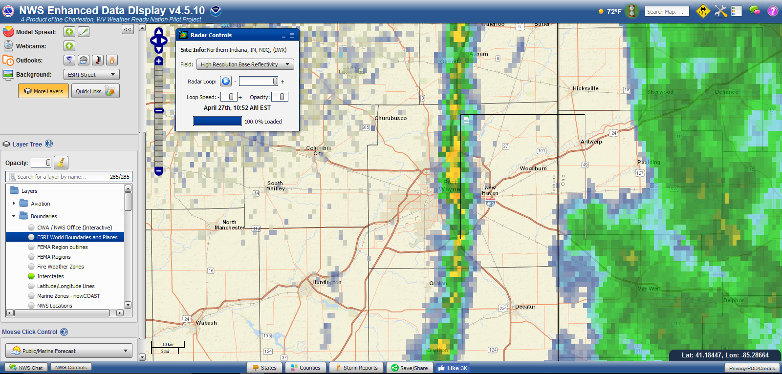 The National Weather Service (NWS) is developing a web application that displays radar data and other information on a map. The Enhanced Data Display (EDD) can be a useful tool for SKYWARN storm spotters, especially those who do not have a radar program like Gibson Ridge’s GRLevel3.


