This map from today’s SPC Day 4 Severe Weather Outlook indicates an area (shaded in yellow) that has a 15% probability of severe weather on Sunday, August 6. It includes the entire state of Indiana.
TLDR: The National Weather Service Storm Prediction Center issued an outlook early this morning that indicates a probability of all forms of severe weather throughout Indiana Sunday, including tornadoes; damaging straight-line thunderstorm winds; and large hail. People should pay attention to reliable sources of weather information as Sunday nears, especially people who are planning outdoor activities Sunday afternoon and evening.
How we know this is possible
The Storm Prediction Center (SPC) is a branch of the U.S. National Weather Service (NWS) that’s responsible for providing timely and accurate forecasts and watches for severe thunderstorms and tornadoes over the contiguous United States. Every day, it issues severe weather outlooks for the current day (Day 1) and for days two (tomorrow), three, four, five, six, seven and eight.
Accurately predicting severe weather more than two days in advance is difficult. So, if the SPC indicates a possibility of severe weather in an outlook for three days from now, it’s wise to pay attention.
In the outlook for Sunday that SPC issued this morning (Aug. 3), it indicated a 15% probability of severe weather, including tornados, damaging straight-line thunderstorm winds and large hail, within 25 miles of any point in Indiana as well as parts of neighboring states.
Tornadoes, damaging straight-line winds and large hail are all possible in Indiana Sunday.
Why is 15% a big deal?
As percentages go, 15% looks pretty small. But that’s because severe storms don’t happen all the time. The SPC, in collaboration with another branch of the NWS, the NOAA National Severe Storms Laboratory (NSSL), analyzes historical weather data to determine the normal probability of severe weather on any given date (based on how many times it happened on that date in the past). That analysis indicates that in Indiana, the normal probability of severe weather on any August 6 is 2% to 3% (depending on where in the state, see graphic below).
SPC/NSSL map showing probabilities of severe weather in various parts of the continental United States on any August 6, based on data collected between 1982 and 2011.
That means Sunday’s 15% probability of severe storms is 5 to 7.5 times what’s normal for that date.
What’s most likely, tornadoes or severe thunderstorms?
Day 4 is too far away for SPC to provide probabilities for specific severe weather hazards, like tornados. Nonetheless, the text of today’s Day 4 outlook implies that tornadoes, damaging straight-line winds and large hail are all possible in Indiana Sunday.
In addition. local NWS offices in Indiana issued their own outlooks today that indicate the possibility of severe weather Sunday, especially in the afternoon and evening. These local outlooks also indicate the NWS might need reports from trained, volunteer storm spotters Sunday.
Tomorrow, SPC will issue a Day 3 outlook for Sunday that will provide a categorical risk level from one to five (five being the greatest risk) and possibly modify the target area based on the latest available weather data.
Saturday, SPC will issue a Day 2 outlook for Sunday that will provide individual probabilities of a tornado, damaging straight-line thunderstorm winds (58 mph or stronger), and large hail (one inch or larger). By then, we’ll have a much better idea of what parts of the state have the highest risk and which hazards are most likely.
What should you do now?
No matter who you are, if you’ll be in Indiana Sunday afternoon and evening, and especially if you plan to be involved in an outdoor activity, pay close attention to a trusted source of weather information as Sunday approaches, such as your local NWS office or professional broadcast meteorologists. If you don’t have a weather alert radio in your home, this would be a good time to buy one.
If you’re a trained Skywarn storm spotter like me, prepare for possible activation Sunday, including charging all your battery-powered devices and reviewing what to look for, what to report, and how to report it. The NWS will likely need your eyewitness reports so they can issue the best warnings and keep people safe.
Path of a tornado that touched down just west of the Eel River Golf Course south of Churubusco and tracked rapidly east southeast, crossing US 33 before dissipating in a corn field west of Chase Road. NWS image.
“But wait,” you might say, “I never heard about a tornado warning for Allen County that day!” That’s because IWX didn’t issue a tornado warning for this storm. At the time of the tornado, however, a severe thunderstorm warning was in effect that included the words, “tornado possible.”
Most severe thunderstorm warnings do not automatically create alerts on your cell phone.
It’s not unusual for the kind of storm we had Saturday morning (a bowing “squall line”) to spawn weak tornados that appear and disappear before the National Weather Service can issue a warning. That’s why, when they warn us of a severe thunderstorm that could contain such tornados, they mention that a tornado is possible.
Weather radar loop slowing the bowing squall line that moved across Indiana early July 29.
It’s also one reason that it’s so important to know about and react appropriately to severe thunderstorm warnings, including those the National Weather Service issues in the middle of the night, when you’re sleeping. But that requires extra effort on your part, because most severe thunderstorm warnings do not automatically create alerts on your cell phone.
If you’ve ever been someplace covered by a tornado warning, you probably received a Wireless Emergency Alert (WEA) on your phone, even if you never installed a weather app. That’s because all modern smartphones come with WEAs enabled and all tornado warnings prompt WEAs.
The only severe thunderstorm warnings that trigger WEAs, however, are those in which the National Weather Service includes a “destructive” damage threat “tag.” They do that for storms that have either hail that’s at least 2.75 inches in diameter (baseball-sized) and/or 80 mph straight-line thunderstorm winds. According to Saturday morning’s severe thunderstorm warning, meteorologists expected winds of up to 60 mph and no large hail. That warning therefore did not trigger a WEA.
So, how can you know if a storm like Saturday’s is headed toward your home in the middle of the night, while you’re asleep? I know of two really good ways:
Buy a weather alert radio and keep it near enough to your bedroom to wake you.
Install a weather alert app, like Storm Shield, and configure it to alert you to severe thunderstorm warnings.
When the NWS issues a severe thunderstorm warning for your location, the best way to be safe is to do the same thing you’d do in a tornado warning. Move to the most interior room on the lowest level of your house. This will provide the best protection from a brief tornado, like the one that touched down July 29 and from straight-line thunderstorm winds dropping a tree limb on your house, which is what killed a woman in Ohio City, Ohio July 20.
My safe place during tornado warnings is the only room in our single-story house that has neither windows nor exterior walls. The portable ham radio provides situational awareness while sheltered and a means of communication if the cellular phone system fails.
April 4, 2018 is national safe-place selfie day. It’s a campaign to help educate people about safe places to take shelter, especially during dangerous weather. The National Weather Service explains the campaign on its website.
You can help with the public education effort by simply going to your shelter (whatever it is at your location), taking a photo of yourself and then posting that photo on your social media channels, along with the hash tag #SafePlaceSelfie.
For example, I posted the photo above on Twitter, Facebook, Instagram and SnapChat.
Show the world how you shelter! Post a #SafePlaceSelfie.
If you’re already a volunteer storm spotter, this class will provide a valuable refresher on what to look for what to report and what’s not really useful to warning meteorologists.
The class is also great for anyone who has any interest in severe weather, even if you don’t plan to be a regular volunteer storm spotter in the NWS SKYWARN program.
Although amateur (ham) radio operators have been an integral part of the SKYWARN program since its inception, you need not be a ham to become a SKYWARN storm spotter. There are now many other ways to send storm reports to your local NWS office. Ham radio capabilities remain helpful, however, for improved situational awareness and as a communication tool when other means fail.
As you can read in the flyer below, the class starts at 7 p.m. at the Academy, 7602 Patriot Crossing, Fort Wayne. That’s the big building behind the Walmart and Menards stores on U.S. 27 south of Tillman Road, on the south edge of Fort Wayne. Doors open for check-in at 6:30 p.m.
The class is free but pre-registration is expected. To register, simply go to http://alleninspotter.eventzilla.net/web/event?eventid=2138917591. If you know someone who wants to attend who has no internet access, have them register by phone by calling 260-449-4671.
I’ve taken the class every year for more years than I can remember and I always get something out of it. If you have any questions, feel free to leave a comment here or on the National Weather Service Northern Indiana Facebook page.
If you don’t live near Fort Wayne, US National Weather Service Northern Indiana plans to offer the same clase at multiple locations in northern Indiana, northwestern Ohio and southern Lower Michigan. You can find a complete list of the office’s classes here. If you live outside the area covered by the National Weather Service Northern Indiana office, contact the NWS office nearest you to learn when and where it will conduct storm spotter classes.
After a small tornado outbreak in Indiana and neighboring states yesterday, I’ve been looking at some tornado videos published by storm chasers. On at least two of them, one can hear on the audio track references to calling 911 to report the tornado. On one, you can hear a chaser instructing a public safety answering point (PSAP) operator to activate warning sirens.
Here’s my question: Why would storm chasers — who one would expect to be familiar with the National Weather Service (NWS) warning system — call 911 instead of the NWS?
Why would storm chasers — who one would expect to be familiar with the National Weather Service (NWS) warning system — call 911 instead of the NWS?
Sure, a call to the local PSAP might lead to activation of outdoor warning sirens, which might alert some nearby residents — especially ones who are outdoors — that something is going on. But it won’t lead to activation of NOAA weather radios, wireless emergency alerts on cellular phones, or alerts on broadcast channels until and unless the NWS knows about the tornado and issues an official tornado warning.
You might think that a call to 911 will get a report to the NWS. In reality, that’s not necessarily true. I’ve attended several meetings of an NWS integrated warning team, where PSAP representatives have repeatedly said that during periods of severe weather, they’re so busy answering phones, that they don’t have time to call NWS. And an NWS warning coordination meteorologist has personally told me that his office yearns to know what citizens are reporting to 911, but can’t get the information.
Granted, calling 911 is easy, especially for chasers whose anxiety levels have reached a near panic stage as they stare down tornadoes. After all, calling 911 when something bad happens is almost a reflex. But a single call to the NWS would get life-saving information to a whole lot more people who are in the path of the storm.
There is a challenge, though, especially for chasers who are always moving from county to county (and for some, state to state) as they try to get in position to see tornadoes. They must always know exactly where they are and they must know which NWS office to call. Adjacent counties are not always served by the same NWS office.
The first part (knowing exactly where you are) is challenging enough, when you’re driving through unfamiliar territory. I’ve heard numerous spotters and chasers, who, while trying to make a report to NWS offices, were unable to say exactly where they were, much less where the funnel cloud or tornado was. Knowing what county your are in and knowing what NWS office serves that county is even more difficult. In truth, any NWS office will accept a tornado report from outside its area and get that information immediately to the correct office. So calling the “wrong” NWS office is probably still better than calling 911, when it comes to warning the most people.
But there’s an even better solution. Members of Spotter Network, Inc. can use a combination of location-reporting software on their smartphones and the Spotter Network website to learn immediately the phone number of the NWS office that covers whatever location they’re in at the moment.
The Spotter Network website can tell members where they are, which NWS office to call, and the phone number for that office.
By using the location-beaconing software, staying logged into the Spotter Network website and bookmarking the “Submit Severe Report” page above, chasers and spotters can learn the best NWS number to call with a couple touches of their smartphones. The result will be warning a lot more people a lot sooner than calling 911 can.
I was surprised and honored that this blog was chosen by the northern Indiana office of the National Weather as a 2017 Weather-Ready Nation Ambassador of Excellence.
If your organization is interested in helping the National Weather Service spread important weather safety messages, check out the WRN Ambassador program.
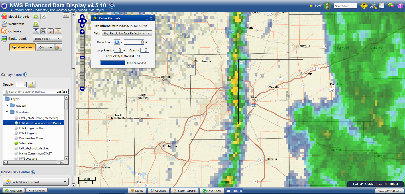
The National Weather Service (NWS) is developing a web application that displays radar data and other information on a map. The Enhanced Data Display (EDD) can be a useful tool for SKYWARN storm spotters, especially those who do not have a radar program like Gibson Ridge’s GRLevel3.
EDD can display standard radar base reflectivity data (that common radar image that shows where the rain is and how heavy it is). It can also show velocity products, that show potential rotation in storms.
EDD can also geographically display a large number of NWS products, including convective outlooks, mesoscale discussions, watches and warnings. Once you display any of these products, you can zoom in to specific areas of interest. This can be useful, for example, if you want to learn whether your home is under a level 1 (marginal) or level 2 (slight) risk in a convective outlook, or whether your home is inside or outside a tornado warning polygon.
You can also optionally choose to add layers for features such as county lines, NWS county warning area lines, etc.
Although the application is officially still experimental (which means it might not always work as expected), it’s open to the public and available for you to try. I recommend playing around with it to see how it could help you with your situational awareness.
This is a “reprint” of an article I submitted to the March issue of Allen County HamNews, the monthly newsletter of all three Fort Wayne-based ham radio clubs.
An unusually large crowd of 135 people attended SKYWARN storm spotter training at the Public Safety Academy on the south side of Fort Wayne Feb. 21. That compares to 87 in 2016 and 91 in 2015.
This year’s presentation included video and images from the Aug. 24, 2016 tornado outbreak. Some interesting tidbits from the presentation included:
National Weather Service Press Release
FOR IMMEDIATE RELEASE March 14, 2016
INDIANA SEVERE WEATHER PREPAREDNESS WEEK, MARCH 20-26
******** STATEWIDE TORNADO DRILLS MARCH 22nd ********
Syracuse, IN – So far, 2016 severe weather does not compare with the tragic March 2012 tornadoes to strike southern Indiana. Is that a sign for fewer tornadoes this year? “Indiana has tornadoes every year,” said Michael Lewis, Warning Coordination Meteorologist with the National Weather Service in Northern Indiana. “But events like the deadly tornado of March 2012 point to the importance of being ready and responsive in the face of increasing hazardous weather events. Being resilient is part of the vision of the National Weather Service (NWS) as we grow toward becoming a Weather Ready Nation,” added Lewis.
The National Weather Service, in cooperation with the Indiana State Department of Homeland Security, Indiana State Police, Indiana Department of Education, the Indiana Broadcasters Association, the American Red Cross, and the amateur radio community, will conduct a Severe Weather Preparedness campaign March 20-26, 2016.
The 38th annual statewide test tornado drills will be conducted on Tuesday March 22 at 10:15 am and 7:35 pm EDT. Wednesday March 23 is the make-up drill day if severe weather postpones Tuesday’s drill. The drill will be initiated by TEST Tornado Warnings issued by NWS offices serving Indiana, triggering programmed electronic devices and activation of many outdoor warning sirens.
“Every family, every school, and every business should take time now to review or create a weather safety action plan,” said John Erickson, Public Information Officer of the Indiana Department of Homeland Security. “Having and practicing a plan increases your chances of surviving the storm,” added Erickson.
For further information, you may refer to: www.weather.gov/ind also:
A conference room full of storm spotters, emergency managers, meteorology students and other weather enthusiasts attended the 2016 Central Indiana Severe Weather Symposium March 7 on the campus of Butler University in Indianapolis. Photo from Twitter by Daniel McCarthy, NWS Indianapolis (@Torn8oDan).
The 2016 Central Indiana Severe Weather Symposium, hosted by the Indianapolis office of the National Weather Service (NWS) and the Indiana chapter of the American Meteorological Society, provided a full day of interesting presentations. Below are a few highlights.
Squall lines made cooler
NWS meteorologist John Kwiatkowski presents on quasi-linear convective systems. Photo from Twitter by John Dissauer (@johndissauer).
John Kwiatkowski of the NWS Indianapolis office provided a presentation on Quasi-Linear Convective Systems (QLCS). Early in his talk, Kwiatkowski explained that this is the same type of storm that meteorologist formally called a “squall line.” Kwiatkowski joked that the new name sounds much cooler and that using it will impress members of the opposite sex.
QLCSs are much more common in Indiana than are supercell thunderstorms. Yet, as Kwiatkowski explained, spotting a QLCS in the field can be more dangerous than watching a discrete supercell out in the plains. Part of a QLCS can produce very damaging straight-line winds without appearing any different to a field observer than any other part of the storm. It can also produce essentially invisible, rain-wrapped tornadoes which, while small and brief, can easily overturn a spotter’s car. Kwiatkowski advised staying home and reporting damage after the storm passes.
It’ll never happen to me (and if it does, I can handle it)
Dr. Laura Myers presents on weather psychology. Photo by NWS Indianapolis
Dr. Laura Myers, a research scientist at the University of Alabama’s Center for Advanced Public Safety, provided a presentation titled “Weather Psychology of the Public: Integration of Social Science Research Results in Products and Practice.” She pointed out a variety of issues regarding how (and whether) people respond to weather warnings.
Myers said that a significant challenge of the weather enterprise is to make people understand that the benefits of safe behavior outweigh the costs and inconvenience.
Among the many discoveries she presented were some that will likely surprise weather enthusiasts:
Most people either don’t believe severe weather will ever affect them (it will always happen to someone else), or they believe that they are uniquely able to handle it.
Not everyone has a single, good warning modality, but people should have more than two.
Upon first learning of a weather alert, people often waste time seeking secondary confirmation, sometimes leaving insufficient time to take adequate shelter.
Most people don’t know what county they are in, even if they live there.
The tone, seriousness and message of broadcast meteorologists can make a difference in how people respond to threats.
Words like “emergency” in weather communications prompt more action but must be used sparingly.
During the 2012 derecho, severe thunderstorm warnings did not lead people to understand how dangerous the storm was. Many told surveyors that they would have behaved differently, had they known what the storm would do.
Storm spotters, chasers and other weather enthusiasts are in a unique position to help change how people respond to severe weather threats. As I’ve written before (see “Storm spotters as advocates“), we are often the trusted weather experts in our families and social circles. We can take advantage of that position to help those people understand how to stay safe.
Mobile home! Duck!
Well-known storm chaser Jeff Piotrowski discusses how he chased the 2013 El Reno, Oklahoma tornado. Photo from Twitter by Kalie Pluchel (@KaliePluchelWX).
Well-known storm chaser Jeff Piotrowski discussed how he chased the 2013 El Reno tornado, the widest tornado in recorded history. His presentation included a great deal of compelling video of the storm.
At one point during the chase, a mobile home flew over Piotrowski’s car close enough to knock off a roof-mounted camera and antenna. Piotrowski saw it coming just in time to tell his wife to duck.
Piotrowski told the crowd that second-by-second situational awareness — including looking at the sky, not just a radar — is the only reason he survived the tornado. He said that during a chase, he never shuts off his car’s engine. And he reminded the audience that debris can travel four miles from tornado.
A peek behind the curtain
NWS meteorologist Amanda Lee begins a presentation on what goes on at the Indianapolis NWS office during severe weather events. Photo from Twitter by John Lobban Radio (@JohnLobbanRADIO)
NWS Meteorologists Amanda Lee and Marc Dahmer provided a behind-the-scenes look at how the their Indianapolis office works during severe weather, complete with entertaining video shot in the forecast office.
They showed how the NWS WarnGen software creates warnings based on choices the warning meteorologist makes.
They also showed how the general public can access data from post-event damage assessments, sometimes within minutes of data entry in the field. The public-view version of the NWS Damage Assessment Toolkit is at https://apps.dat.noaa.gov/StormDamage/DamageViewer/. It requires Adobe Flash, which makes it inaccessible on iOS devices.
Building a Weather-Ready Nation
NWS Indianapolis warning coordination meteorologist Dave Tucek discusses the NWS Weather-Ready Nation program. Photo from Twitter by Mike Alley (@malley57)
Dave Tucek, warning coordination meteorologist for the Indianapolis NWS office, provided an introduction the the agency’s “Weather-Ready Nation” (WRN) initiative. His talk included information on severe weather climatology and the value of organizations becoming WRN Ambassadors. Although the Ambassador designation is not available to individuals, Tucek pointed out that “We all have a part in spreading the weather-ready message.”
No green screen
Chris Wright of WTTV TV-4, Indianapolis, speaks about his career as a weather broadcaster. Photo from Twitter by John Dissauer (@johndissauer).
Chris Wright of WTTV TV-4, Indianapolis, spoke about his career as a weather broadcaster. Interesting tidbits from his presentation included:
His station uses no green screen. Instead of chroma key, his weather graphics appear on a bank of nine video monitors.
During severe weather break-ins, it’s not unusual for a superior to tell him to keep talking. Wright told the crowd that if they see a weather break-in that lasts for more than 30 seconds, it wasn’t the weather person’s decision.
News anchors often don’t watch the weather segment of a newscast. That’s why the weather person recaps the forecast as part of his hand off back to the anchors.
Social media has significantly increased the workload in TV weather departments. Wright said that keeping up with Twitter, Facebook, blogs, etc. sometimes requires having two people per shift.
At colleges, students aren’t always the biggest emergency management challenge
IUPUI emergency manager Carlos Garcis talks about weather hazard management on a college campus. NWS photo.
Carlos Garcia, emergency manager for the Indiana University – Purdue University Indianapolis campus, talked about how the campus prepares for severe weather.
He said federal law requires universities to warn their communities of threats in a timely manner. He pointed out that college students are adults, who need to accept responsibility for their decisions in emergency situations. But he also indicated that students aren’t necessarily the biggest challenge with regard to appropriate response to notifications. That’s one reason the campus invested in software for all campus computers that can automatically display alerts. The software will even interrupt a professor’s PowerPoint presentation, displaying a notification to everyone in the classroom of the situation.
Photo gallery
A gallery of photos of the event from Gregory Chaney is available on Flickr.


 After a small tornado outbreak in Indiana and neighboring states yesterday, I’ve been looking at some tornado videos published by storm chasers. On at least two of them, one can hear on the audio track references to calling 911 to report the tornado. On one, you can hear a chaser instructing a public safety answering point (PSAP) operator to activate warning sirens.