The Allen County Office of Homeland Security issued the following news release this morning:
Allen County Office of Homeland Security Supports National Severe Weather Preparedness Week March 2-8
The Allen County Office of Homeland Security is proud to support National Severe Weather Preparedness Week, March 2-8, 2014. Sponsored by the Federal Emergency Management Agency (FEMA) and the National Oceanic Atmospheric Administration (NOAA), National Severe Weather Preparedness Week is a nationwide effort designed to increase awareness of the severe weather that affects everyone and to encourage individuals, families businesses and communities to know their risk, take action, and be an example.
The Allen County public information officer posted the following on the county’s Facebook page this morning:
Allen County Highway Condition Update: 9 a.m.
As of 9 a.m. Wednesday, the Allen County Highway Department South Barn reports these roads closed due to high water:
•Bostic Road between South Anthony Extension & the new Bostic Rd. Bridge •South County Line Road between US 27 & Winchester Rd. •Marion Center Road between US 27 & Winchester Rd.
Our Allen County Office of Homeland Security now has its own Facebook page! Make sure to “like” this page to get… http://t.co/DR9GinUND5 — Allen County INfo (@allencountyinfo) February 26, 2014
The northern Indiana office of the National Weather Service issued the following statement at 9:12 a.m. EST:
THE NATIONAL WEATHER SERVICE IN NORTHERN INDIANA HAS CANCELLED THE WIND CHILL ADVISORY. TEMPERATURES WILL SLOWLY RISE TO AROUND 10 DEGREES BY LATE MORNING. WIND CHILLS ARE EXPECTED TO REMAIN IN THE 5 BELOW TO 10 BELOW RANGE THIS MORNING. THEREFORE…THE WIND CHILL ADVISORY HAS BEEN CANCELLED.
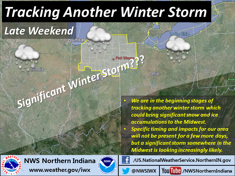
A significant winter storm remains possible in northeastern Indiana and northwestern Ohio this weekend, according to statements issued this morning by the northern Indiana office of the National Weather Service.
White area indicates county warning area of the northern Indiana NWS office
“Accumulating snow is likely in the area from Saturday night through Sunday night,” the NWS wrote in its daily Hazardous Weather Outlook at 5:12 a.m. today. “At this time, heaviest accumulations are expected across southeastern portions of the area.” The “area” to which the outlook refers above is the 37-county area served by the northern Indiana office (see map at right). So, the outlook is indicating that the current forecast track of the storm would bring, for example, more snow to Fort Wayne than to South Bend.
Meteorologists put additional information in the Area Forecast Discussion the office issued at 4:15 a.m., in which they indicated that a “more significant snow event” is possible Saturday night through Sunday with the “potential for significant snow accumulations,” especially across the southeastern portion of the office’s forecast area (see note above). However, there are still substantial differences in model forecasts regarding where the band of heaviest precipitation will fall.
Flood water begins to cover park land along Tillman Road in southern Fort Wayne at midday Tuesday, Feb. 25. (W9LW photo)
At 9:11 p.m. yesterday, the National Weather Service extended its flood warning for the St. Mary’s River, as measured at Muldoon Bridge (South Anthony Blvd. Extended), just upstream from Fort Wayne. The warning now remains in effect until 6 a.m. Friday.
At 7:30 a.m. today, the river level was 14.92 feet, which is .92 feet above flood stage, causing minor flooding. That level is the forecast crest, so the river should begin falling today.
At 15.0 feet, flooding occurs on the lowest, unprotected city streets, park drives and county roads.
URGENT - WINTER WEATHER MESSAGE
NATIONAL WEATHER SERVICE NORTHERN INDIANA
209 PM EST TUE FEB 25 2014

...BITTERLY COLD CONDITIONS TONIGHT THROUGH WEDNESDAY MORNING...

.AN ARCTIC FRONT WILL TRACK ACROSS THE AREA TONIGHT BRINGING
ANOTHER ARCTIC AIRMASS TO THE REGION.

LA PORTE-ST. JOSEPH IN-ELKHART-NOBLE-STARKE-PULASKI-MARSHALL-
FULTON IN-KOSCIUSKO-WHITLEY-ALLEN IN-WHITE-CASS IN-MIAMI-WABASH-
HUNTINGTON-WELLS-ADAMS-GRANT-BLACKFORD-JAY-

INCLUDING THE CITIES OF...MICHIGAN CITY...LA PORTE...SOUTH BEND...
MISHAWAKA...NEW CARLISLE...WALKERTON...ELKHART...GOSHEN...
NAPPANEE...KENDALLVILLE...LIGONIER...ALBION...KNOX...
NORTH JUDSON...BASS LAKE...WINAMAC...FRANCESVILLE...MEDARYVILLE...
PLYMOUTH...BREMEN...CULVER...ROCHESTER...AKRON...WARSAW...
WINONA LAKE...SYRACUSE...MENTONE...COLUMBIA CITY...TRI-LAKES...
SOUTH WHITLEY...FORT WAYNE...NEW HAVEN...MONTICELLO...BROOKSTON...
MONON...LOGANSPORT...ROYAL CENTER...PERU...GRISSOM AFB...MEXICO...
WABASH...NORTH MANCHESTER...HUNTINGTON...ROANOKE...BLUFFTON...
OSSIAN...DECATUR...BERNE...MARION...GAS CITY...UPLAND...
HARTFORD CITY...MONTPELIER...PORTLAND...DUNKIRK

...WIND CHILL ADVISORY IN EFFECT FROM MIDNIGHT EST /11 PM CST/
TONIGHT TO NOON EST /11 AM CST/ WEDNESDAY...

THE NATIONAL WEATHER SERVICE IN NORTHERN INDIANA HAS ISSUED A
WIND CHILL ADVISORY...WHICH IS IN EFFECT FROM MIDNIGHT EST /11 PM
CST/ TONIGHT TO NOON EST /11 AM CST/ WEDNESDAY.

HAZARDOUS WEATHER...

 * FALLING TEMPERATURES OVERNIGHT COMBINED WITH BRISK WEST WINDS
   WILL RESULT IN WIND CHILLS DROPPING TO 10 BELOW TO 20 BELOW
   OVERNIGHT INTO WEDNESDAY MORNING.

IMPACTS...

 * WIND CHILLS THIS LOW CAN RESULT IN FROSTBITE TO EXPOSED SKIN
   IN AS LITTLE AS 30 MINUTES.

PRECAUTIONARY/PREPAREDNESS ACTIONS...

A WIND CHILL ADVISORY MEANS THAT VERY COLD AIR AND STRONG WINDS
WILL COMBINE TO GENERATE LOW WIND CHILLS. THIS WILL RESULT IN
FROST BITE AND LEAD TO HYPOTHERMIA IF PRECAUTIONS ARE NOT TAKEN.
IF YOU MUST VENTURE OUTDOORS...MAKE SURE YOU WEAR A HAT AND
GLOVES.
Meteorologists are begin to see indications of a winter storm over the coming weekend. The northern Indiana National Weather Service (NWS) office issued a Hazardous Weather Outlook at 4:31 a.m. today that reads, in part:
“A developing winter storm will bring the potential for accumulating snow to the area from Saturday night through Sunday night.”
The office issued an Area Forecast Discussion at 3:50 a.m. that indcates that details are still to be resolved but a period of “impactful” winter weather looks “increasingly likely” in the Saturday night to Sunday night time frame.
That’s just a hint but this far in advance, it’s all we get. Keep your eye on NWS forecasts for the next several days!
The National Weather Service (NWS) has extended a flood warning for the St. Mary’s River in Fort Wayne until 9 a.m. tomorrow. As of this morning, minor flooding was occurring and is forecast to continue.
At 7:30 a.m., the river level at the flood gauge at Muldoon Bridge (South Anthony Blvd. Extended) was 14.39 feet, which is .39 feet above flood stage.
As of the most recent NWS statement at 9:59 p.m. last night, the river was forecast to crest near 14.8 feet at around 7 p.m. today and remain above flood stage until 9 a.m. tomorrow.
At 15.0 feet (just 2.4 inches above the forecast crest), flooding occurs on the lowest unprotected city streets, park drives and county roads.
SKYWARN spotters should continue to report any flooding they see while in the area of the St. Mary’s River in Fort Wayne.