Winter weather advisory issued for northeastern Indiana, northwestern Ohio, southern lower Michigan

NWS Winter Weather Advisory infographic

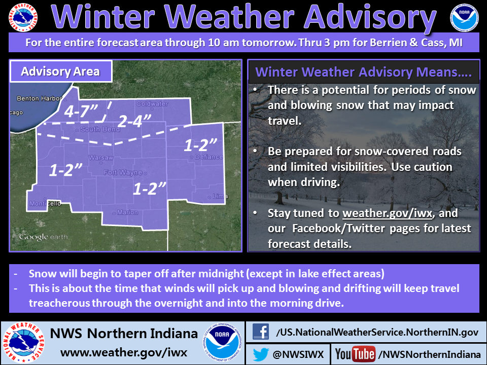
The northern Indiana office of the national weather service has issued a winter weather advisory for its coverage area. The verbatim text appears below. Read carefully because there are slight differences in the wording, depending on what county you’re in.

URGENT - WINTER WEATHER MESSAGE
NATIONAL WEATHER SERVICE NORTHERN INDIANA
436 PM EST WED JAN 22 2014

.AN ARCTIC FRONT WILL QUICKLY MOVE THROUGH THE REGION FROM
NORTHWEST TO SOUTHEAST THROUGH THIS EVENING. A BURST OF MODERATE
SNOW WILL ACCOMPANY THE FRONT WITH MOST LOCATIONS RECEIVING A
QUICK 1 TO 2 INCHES OF SNOW BEFORE DRIER AIR MOVES IN. BEHIND THE
FRONT...STRONG NORTHWEST WINDS WILL CAUSE AREAS OF BLOWING AND
DRIFTING SNOW...ESPECIALLY IN OPEN AND RURAL AREAS. LAKE EFFECT
SNOW SHOWERS WILL DEVELOP AND PERSIST ACROSS BERRIEN AND CASS
COUNTIES IN MICHIGAN WITH ONE OF MORE BANDS OCCASIONALLY DROPPING
INTO THE FAR NORTHERN PORTIONS OF LAPORTE...ST JOSEPH INDIANA AND
ELKHART COUNTIES. THE LAKE EFFECT SNOW WILL CONTINUE INTO
THURSDAY AFTERNOON WITH TOTAL ACCUMULATIONS FROM 4 TO 7 INCHES
ACROSS FAR SOUTHWESTERN LOWER MICHIGAN TO 2 TO 4 INCHES ACROSS
FAR NORTHERN INDIANA. IN ADDITION...OVERNIGHT LOWS INTO THE
SINGLE DIGITS ABOVE AND BELOW ZERO WILL CAUSE WIND CHILLS OF 12
TO 20 DEGREES BELOW ZERO...ESPECIALLY ACROSS MUCH OF NORTHERN
INDIANA AND NORTHWESTERN OHIO.

MIZ077-078-230545-
/O.CON.KIWX.WW.Y.0004.000000T0000Z-140123T2100Z/
BERRIEN-CASS MI-
INCLUDING THE CITIES OF...NILES...BENTON HARBOR...ST. JOSEPH...
BUCHANAN...DOWAGIAC...CASSOPOLIS...MARCELLUS
436 PM EST WED JAN 22 2014

...WINTER WEATHER ADVISORY REMAINS IN EFFECT UNTIL 4 PM EST
THURSDAY...

HAZARDOUS WEATHER...

* PERIODS OF LIGHT TO MODERATE SNOW WILL CONTINUE THIS EVENING
WITH 1 TO LOCALLY 2 INCHES OF SNOW. LAKE EFFECT SNOW SHOWERS
WILL DEVELOP BY LATE EVENING AND CONTINUE INTO THURSDAY
AFTERNOON BRINGING THE POTENTIAL FOR AN ADDITIONAL 3 TO 5
INCHES OF SNOW. STORM TOTALS OF 4 TO 7 INCHES CAN BE EXPECTED
BY MIDDAY THURSDAY. WINDS WILL INCREASE OVERNIGHT CAUSING
BLOWING AND DRIFTING SNOW AND WIND CHILLS AROUND 15 BELOW
ZERO.

IMPACTS...

* ROADS WILL BECOME SNOW COVERED AND HAZARDOUS. VISIBILITIES
MAY BE LIMITED IN SOME AREAS TONIGHT DUE TO SNOW AND BLOWING
SNOW.

PRECAUTIONARY/PREPAREDNESS ACTIONS...

A WINTER WEATHER ADVISORY FOR SNOW AND BLOWING SNOW MEANS THAT
VISIBILITIES WILL BE LIMITED DUE TO A COMBINATION OF FALLING AND
BLOWING SNOW. USE CAUTION WHEN TRAVELING... ESPECIALLY IN OPEN
AREAS.

&&

$$

INZ003>005-230545-
/O.CON.KIWX.WW.Y.0004.000000T0000Z-140123T1500Z/
LA PORTE-ST. JOSEPH IN-ELKHART-
INCLUDING THE CITIES OF...MICHIGAN CITY...LA PORTE...SOUTH BEND...
MISHAWAKA...NEW CARLISLE...WALKERTON...ELKHART...GOSHEN...
NAPPANEE
436 PM EST WED JAN 22 2014 /336 PM CST WED JAN 22 2014/

...WINTER WEATHER ADVISORY REMAINS IN EFFECT UNTIL 10 AM EST
/9 AM CST/ THURSDAY...

HAZARDOUS WEATHER...

* A BURST OF MODERATE SNOW WILL OCCUR THIS EVENING WITH 1 TO 2
INCHES OF SNOW POSSIBLE. LAKE EFFECT SNOW SHOWERS WILL THEN
DEVELOP AND MAY IMPACT LOCATIONS ALONG AND NORTH OF THE TOLL
ROAD INTO THURSDAY WITH AN ADDITIONAL 1 TO 2 INCHES. LOCALLY
HIGHER AMOUNTS WILL BE POSSIBLE. STRONG NORTHWEST WINDS WILL
CAUSE BLOWING AND DRIFTING SNOW AS WELL AS WIND CHILLS TO 10
TO 15 BELOW ZERO.

IMPACTS...

* ROADS WILL BECOME SNOW COVERED AND HAZARDOUS. VISIBILITIES
MAY BE LIMITED IN SOME AREAS TONIGHT DUE TO SNOW AND BLOWING
SNOW.

* EXPOSED SKIN CAN SUFFER FROSTBITE WITH EXTENDED EXPOSURE.

PRECAUTIONARY/PREPAREDNESS ACTIONS...

A WINTER WEATHER ADVISORY FOR SNOW AND BLOWING SNOW MEANS THAT
VISIBILITIES WILL BE LIMITED DUE TO A COMBINATION OF FALLING AND
BLOWING SNOW. USE CAUTION WHEN TRAVELING... ESPECIALLY IN OPEN
AREAS.

&&

$$

INZ006>009-012>018-020-022>027-032>034-MIZ079>081-OHZ001-002-004-
005-015-016-024-025-230545-
/O.CON.KIWX.WW.Y.0004.000000T0000Z-140123T1500Z/
LAGRANGE-STEUBEN-NOBLE-DE KALB-STARKE-PULASKI-MARSHALL-FULTON IN-
KOSCIUSKO-WHITLEY-ALLEN IN-WHITE-CASS IN-MIAMI-WABASH-HUNTINGTON-
WELLS-ADAMS-GRANT-BLACKFORD-JAY-ST. JOSEPH MI-BRANCH-HILLSDALE-
WILLIAMS-FULTON OH-DEFIANCE-HENRY-PAULDING-PUTNAM-VAN WERT-
ALLEN OH-
INCLUDING THE CITIES OF...LAGRANGE...TOPEKA...SHIPSHEWANA...
ANGOLA...FREMONT...KENDALLVILLE...LIGONIER...ALBION...AUBURN...
GARRETT...KNOX...NORTH JUDSON...BASS LAKE...WINAMAC...
FRANCESVILLE...MEDARYVILLE...PLYMOUTH...BREMEN...CULVER...
ROCHESTER...AKRON...WARSAW...WINONA LAKE...SYRACUSE...MENTONE...
COLUMBIA CITY...TRI-LAKES...SOUTH WHITLEY...FORT WAYNE...
NEW HAVEN...MONTICELLO...BROOKSTON...MONON...LOGANSPORT...
ROYAL CENTER...PERU...GRISSOM AFB...MEXICO...WABASH...
NORTH MANCHESTER...HUNTINGTON...ROANOKE...BLUFFTON...OSSIAN...
DECATUR...BERNE...MARION...GAS CITY...UPLAND...HARTFORD CITY...
MONTPELIER...PORTLAND...DUNKIRK...STURGIS...THREE RIVERS...
WHITE PIGEON...MENDON...COLDWATER...BRONSON...HILLSDALE...
LITCHFIELD...JONESVILLE...BRYAN...WAUSEON...ARCHBOLD...FAYETTE...
SWANTON...DEFIANCE...SHERWOOD...HICKSVILLE...NAPOLEON...DESHLER...
LIBERTY CENTER...PAULDING...ANTWERP...MELROSE...OTTAWA...
PANDORA...KALIDA...FORT JENNINGS...VAN WERT...DELPHOS...
OHIO CITY...LIMA...SPENCERVILLE
436 PM EST WED JAN 22 2014 /336 PM CST WED JAN 22 2014/

...WINTER WEATHER ADVISORY REMAINS IN EFFECT UNTIL 10 AM EST
/9 AM CST/ THURSDAY...

HAZARDOUS WEATHER...

* A BURST OF MODERATE SNOW WILL OCCUR THIS EVENING WITH 1 TO 2
INCHES OF SNOW POSSIBLE. STRONG NORTHWEST WINDS WILL CAUSE
BLOWING AND DRIFTING SNOW AS WELL AS WIND CHILLS AROUND 15
BELOW TO 20 BELOW ZERO.

IMPACTS...

* ROADS WILL BECOME SNOW COVERED AND HAZARDOUS. VISIBILITIES
MAY BE LIMITED IN SOME AREAS TONIGHT DUE TO SNOW AND BLOWING
SNOW.

PRECAUTIONARY/PREPAREDNESS ACTIONS...

A WINTER WEATHER ADVISORY FOR SNOW AND BLOWING SNOW MEANS THAT
VISIBILITIES WILL BE LIMITED DUE TO A COMBINATION OF FALLING AND
BLOWING SNOW. USE CAUTION WHEN TRAVELING... ESPECIALLY IN OPEN
AREAS.

&&

$$

Harsh winter conditions continue today

NWS infographic regarding snowfall and temperature forecast

SPECIAL WEATHER STATEMENT
NATIONAL WEATHER SERVICE NORTHERN INDIANA
355 AM EST WED JAN 22 2014

...HARSH WINTER CONDITIONS CONTINUING...

TEMPERATURES WILL BE VERY COLD THIS MORNING...RANGING FROM 5 TO 10
BELOW WHERE SKIES CLEARED OVERNIGHT TO 5 TO 10 ABOVE IN CLOUDY
AREAS. SNOW IS EXPECTED TO DEVELOP THIS AFTERNOON AND CONTINUE
INTO TONIGHT AS A LOW PRESSURE SYSTEM DROPS SOUTHEAST ACROSS THE
AREA. NEW SNOW ACCUMULATIONS BY THURSDAY MORNING SHOULD GENERALLY
BE 1 TO 2 INCHES... EXCEPT 2 TO 4 INCHES ARE EXPECTED IN THE
MICHIGAN CITY... SOUTH BEND... ELKHART CORRIDOR. WINDS ARE
EXPECTED TO INCREASE ACROSS THE ENTIRE AREA TONIGHT CAUSING
BLOWING AND DRIFTING SNOW. THE STRONG WINDS COMBINED WITH THE COLD
TEMPERATURES WILL RESULT IN EXTREMELY COLD WIND CHILLS IN THE 15
TO 25 BELOW RANGE TONIGHT AND INTO THURSDAY MORNING.

How often do SKYWARN storm spotters need training?

SKYWARN logo
Regarding upcoming SKYWARN training sessions about which I wrote Jan. 15, an experienced spotter asked me a great question, specifically referring to the free, online training that the National Weather Service (NWS) recommends people complete before they attend live training sessions.

This spotter asked, “If we took the course last year to get certified, do we need to take it again prior to this year’s training?”

As I replied to him, the answer depends largely on your definition of “need.” But first, let’s clear up a possible misconception.

The northern Indiana NWS office (IWX) trains SKYWARN severe weather spotters, but it does not certify them. As the office explains on one of its Web pages:

Some NWS offices issue ID’s and/or certificates. However, maintaining such a large database in addition to tracking all the ID’s, can be a difficult task. As a result, this office does not issue ID’s or certificates. The host of each training session, typically the county or city Emergency Manager, can issue and track these, at their discretion.

Light green area: County Warning Area (CWA) of the northern Indiana National Weather Service office.

So, if you live in the 37-county warning area (CWA) covered by IWX and think you need recurrent training to maintain an NWS certification, you’re incorrect, only because there’s no such thing as NWS spotter certification in the IWX CWA. But please read on.

The northern Indiana NWS office does maintain a list of trained (not certified) spotters and, “in an effort to maintain an accurate database, spotters who have not received training within 3 years of the their last session will be removed.” So, if you took training (online and/or live) last year, you don’t need to take any training this year to stay on the NWS list of trained spotters. But please read on.

As I wrote above, whether you need training (online or live) this year depends on your own definition of “need.” Unless you are confident that you remember everything you learned last year and that there will be no new information in this year’s training that will be valuable to you, you might need to take both the online and live training again to remain a safe and effective severe weather spotter.

Personally, I plan to go through the online modules again before I attend a live training session this year. And I plan to attend one or more live training sessions as well, plus one or more advanced events (in Indianapolis, Wheaton, Ill., and/or Columbus, Ohio).

NWS: Ice jams pose short-notice flood threat

Photo of ice jam from NWS website.

HYDROLOGIC OUTLOOK
NATIONAL WEATHER SERVICE NORTHERN INDIANA
1020 AM EST FRI JAN 17 2014

...WIDESPREAD ICE IMPACTING AREA RIVERS...

VERY COLD TEMPERATURES HAVE CAUSED ICE TO FORM ON NEARLY ALL RIVERS
ACROSS NORTHERN INDIANA...SOUTHWEST LOWER MICHIGAN AND FAR NORTHWEST
OHIO. RECENT WARMER TEMPERATURES AND RAINFALL CAUSED SOME SNOWMELT
WHICH IN TURN HAS CAUSED RIVERS TO RISE. AS THE RIVERS HAVE RISEN...
ICE HAS FRACTURED AND BEGUN FLOWING DOWNSTREAM. THIS CAN CAUSE
PROBLEMS IF THE ICE GETS STUCK CREATING A BUILD UP IN THE RIVER
/CALLED AN ICE JAM/. THE RIVER BEHIND THE JAM WILL BEGIN TO RISE
AND MAY CAUSE FLOODING. SHOULD THE JAM BREAK UP SUDDENLY...FLOODING
IS POSSIBLE DOWNSTREAM AS WATER IS RELEASED.

IT IS POSSIBLE THAT FLOODING WILL NOT BE DETECTED BY AREA RIVER
GAUGES. THEREFORE...FLOODING MAY OCCUR WITH LITTLE OR NO ADVANCE
WARNING.

RESIDENTS ALONG AREA WATERWAYS SHOULD REMAIN ALERT AND WATCH WATER
LEVELS TO DECIDE IF ANY ACTION IS REQUIRED. PLEASE REPORT ANY FLOODING
ASSOCIATED WITH ICE JAMS TO THE NATIONAL WEATHER SERVICE.

LISTEN TO NOAA WEATHER RADIO FOR FURTHER STATEMENTS AND FORECASTS AS
THIS FLOOD POTENTIAL DEVELOPS.

2014 SKYWARN storm spotter training

SKYWARN logoAcquire and/or update skills needed to be an effective and safe storm spotter for the National Weather Service (NWS) SKYWARN program at one of the following events.

Note that the NWS will not present the training in Fort Wayne in 2014. The events listed below are the ones that are closest to Fort Wayne. The only other 2014 SKYWARN training sessions presented by the northern Indiana NWS office are located in LaGrange, Logansport and South Bend, Indiana, and Archbold and Lima, Ohio.

The NWS recommends that all spotters and future spotters complete the Free Online Spotter Training prior to attending these training sessions.

Please share this information! Every year, after that year’s training sessions are over, NWS offices get calls from people inquiring about training. Help the NWS and future spotters by spreading the word on social networks, etc. If you live outside the area covered by the Northern Indiana NWS office, go to www.weather.gov to find the office that serves your county and look up that office’s website to view its training schedule.

Columbia City

Feb. 18, 2014, 7 p.m.
Columbia City High School
600 N. Whitley St
Columbia City, Ind.
Register in advace for the Columbia City session.

Bluffton

March 17, 2014, 6 p.m.
Wells County Community Center
1240 S. 4-H Road
Bluffton, Ind.
Register in advance for the Bluffton session.

Allen County under winter weather travel advisory

From the Allen County Facebook page:

The Winter Weather Travel WATCH for Allen County — including the cities of Fort Wayne, New Haven and Woodburn — has been downgraded to a Winter Weather Travel ADVISORY until further notice. An ADVISORY means that routine travel or activities may be restricted in areas because of a hazardous situation, and individuals should use caution or avoid those areas. Officials will provide further updates as conditions warrant.

Crash numbers evidence of still-dangerous roads

If you don’t believe the streets and roads are still dangerous, check out this tweet from Fort Wayne’s WANE-TV:

143 accidents reported in FW since Mon. As of 10:20 today, there have been more crashes than there were all day Mon. http://t.co/PZOWaVTQPs
— NewsChannel15 (@wane15) January 8, 2014

Also, see this tweet from INDOT:

Alert: Westbound US 24 east of Fort Wayne, both lanes blocked at Webster Road to remove a semi that slid off the highway.
— INDOT Northeast (@INDOTNortheast) January 8, 2014

Roads still very slick but wind chill advisory canceled

At 4:25 a.m. today, the National Weather Service (NWS) canceled the wind chill advisory that had been in effect for northeastern Indiana. NWS forecast wind chills above -10 degrees today, high enough to be outside its criteria for a wind chill advisory.

While temperatures are rising, roads throughout the area remain slick, as NWS indicated in a Special Weather Statement it issued at 7:27 a.m. EST:

...EXTREMELY SLICK DRIVING CONDITIONS REMAIN FOR MORNING
COMMUTE...

SNOWPACKED ROADS...INCLUDING INTERSTATES AND OTHER MAJOR
ROUTES...WILL REMAIN VERY ICY THIS MORNING. CONDITIONS MAY APPEAR
DECEIVING...HOWEVER THE SNOWPACK HAS BECOME POLISHED BY TRAVEL.
DRIVING TOO FAST MAY CAUSE SUDDEN LOSS OF TRACTION AND CONTROL OF
YOUR VEHICLE. ALLOW EXTRA TIME FOR YOUR MORNING COMMUTE. DRIVE
SLOWLY AND USE CAUTION WHEN APPROACHING CURVES AND BRIDGES. ROAD
CHEMICAL TREATMENTS WILL BEGIN TO BECOME MORE EFFECTIVE BY MIDDAY
AS THE TEMPERATURE RISES INTO THE TEENS.

The above statement is reflected in the Indiana Department of Transportation’s road condition map, which continues to indicate all roads in northeastern Indiana are “difficult.”

Road conditions in northeastern Indiana as of 8:30 a.m. EST Jan. 8. Purple indicates road conditions are “difficult.” Source: INDOT

Local travel advisories as of 9 a.m. Jan. 8. Orange: Travel watch, only essential travel recommended. Yellow: Travel advisory, routine travel or activities may be restricted in areas because of a hazardous situation. White: No advisory. Source: IDHS

As of this morning, no counties in northeastern Indiana continued to restrict travel to emergencies only. The map on the Indiana Department of Transportation website indicates that most area counties are at a “watch” local travel advisory (orange), which means only essential travel, such as to and from work or in emergency situations, is recommended.

Wind chill advisory replaces warning, travel remains difficult

Travel conditions map from INDOT
Road conditions in northeastern Indiana as of 4:20 p.m. EST Jan. 7. Purple indicates road conditions are “difficult.” Source: INDOT

The National Weather Service (NWS) has replaced its Wind Chill Warning with a Wind Chill Advisory, which remains in effect until 9 a.m. EST Wednesday, Jan. 8. You can read the full text of the advisory on the NWS website, but the highlights appear below.

HAZARDOUS WEATHER...

* DEADLY WIND CHILLS BETWEEN 15 BELOW AND 20 BELOW ZERO CAN BE
EXPECTED THIS EVENING AND TONIGHT.

IMPACTS...

* FROST BITE AND HYPOTHERMIA WILL OCCUR QUICKLY WITH THESE
EXPECTED WIND CHILLS.

PRECAUTIONARY/PREPAREDNESS ACTIONS...

A WIND CHILL ADVISORY MEANS THAT VERY COLD AIR AND STRONG WINDS
WILL COMBINE TO GENERATE LOW WIND CHILLS. THIS WILL RESULT IN
FROST BITE AND LEAD TO HYPOTHERMIA IF PRECAUTIONS ARE NOT TAKEN.
IF YOU MUST VENTURE OUTDOORS...MAKE SURE YOU WEAR A HAT AND
GLOVES.

While the danger of cold is easing, the danger of driving is not. As evidence, check out the numerous reports of roads blocked by crashes, etc. on the Twitter feeds of Indiana Department of Transportation and Indiana State Police. Most of the day, ice melting chemicals have not worked on the roads because of the extreme cold. This has left roads extremely slick and hazardous, even where they’ve been plowed and treated. As the temperature rises tomorrow, road should get much better.

Local travel advisories as of 4:35 p.m. Jan. 7. Red: Travel warning, emergency vehicles only. Orange: Travel watch, only essential travel recommended. Yellow: Travel advisory, routine travel or activities may be restricted in areas because of a hazardous situation. White: No advisory. Source: IDHS

According to the website of the Indiana Department of Homeland Security, fewer northern Indiana counties continue to restrict travel to emergencies. Allen County’s travel watch, which recommends essential travel only, remains in effect until further notice, according to a Facebook message.