
The National Weather Service Storm Prediction Center (SPC) might issue a severe thunderstorm watch for parts of extreme northwestern Indiana this afternoon or this evening, according to a mesoscale discussion the SPC issued at 3:11 p.m. EDT. Such a watch would likely cover only a few counties in the northwestern corner of Indiana (e.g. Lake, Porter, Newton, Jasper).
Monthly Archives: June 2013
Slight risk of severe weather in Indiana this week


There’s an increasing risk of severe weather in Indiana over the next few days. The northern third of Indiana has a slight risk of severe weather between 8 a.m. tomorrow, Tuesday, June 25 and 8 a.m. Wednesday, according to the Day 2 Convective Outlook that the Storm Prediction Center issued this morning.. The slight risk area includes Allen County, but just barely.
The following day, however, the entire state of Indiana is at slight risk of severe weather, according to this morning’s Day 3 Convective Outlook. It covers 8 a.m. Wednesday, June 26 through 8 a.m. Thursday.
Michael Lewis, the warning coordination meteorologist at the northern Indiana National Weather Service (NWS) office, sent a message to storm spotters today in which he advised that today would be a good day to check your preparedness and response plans. In addition, spotters should review the reporting criteria and methods on the Northern Indiana Skywarn Spotter Page:
Lewis wrote that as conditions warrant, the office might issue multimedia weather briefings. If so, they’ll be posted on the office’s Facebook, Twitter and home page.
Keep your eye on NWS resources for the next couple of days for updates as they become available.
Big midwestern tropo opening this morning

Sitting here doing client work at my desk, with my VHF/UHF base station scanning memory channels, I’m hearing a lot of distant repeater stations this morning. On 146.76 MHz, the KE8HR repeater in Detroit came in almost full scale on the S-meter! A couple minutes later on the same frequency, I copied the W8RXX repeater in Columbus, Ohio. It wasn’t as strong as the Detroit machine but still copyable. On 147.255, I heard the KC8RCI repeater in Republic, Ohio (north-central part of the state) quite clearly. Then, I heard the 443.100 MHz WR8DAR RACES ARES Disaster Assistance Repeater in Northville, Mich. (near Detroit).
It’s somewhat unusual to hear stations this far away on these frequencies, because signals on these frequencies normally travel only in straight lines. Due to the curvature of the earth they’d normally be much higher above the earth hear in Fort Wayne than is my antenna, so I wouldn’t be able to hear them.
But this morning, we’re experiencing a phenomena called, “tropospheric ducting,” It happens most often on summer mornings and evenings when high atmospheric pressure leads to a temperature inversion
Slight risk of severe weather today in southern Indiana

There’s a slight risk of severe weather this afternoon in the southern half of Indiana, according to a convective outlook from the National Weather Service Storm Prediction Center. Conditions support the development of supercell thunderstorms that could bring large hail and high winds to the area. The risk of tornadoes is very low. At 2:04 p.m. EDT, the SPC announced in a mesoscale discussion that a watch is possible in part of southwestern Indiana.
NWS finds evidence of fourth tornado in Henry County, Ohio

National Weather Service (NWS) surveyors have found evidence of a fourth tornado in Henry County, Ohio June 13, 2013. This brings to five the total number of tornadoes in area covered by the northern Indiana NWS office from the event June 13 outbreak. The updated map graphic above shows the locations of the four Henry County tornadoes. See the surveyors’ complete report on the NWS website. NWS is updating that report continually, as new information comes in.
NWS publishes photos from June 13, 2013 storms
 |
| June 13, 2013 straight-line wind damage to farm buildings near Wabash, Indiana (NWS photo) |
The northern Indiana National Weather Service office has posted an album of photos from the June 13, 2013 storms on Facebook (you don’t need a Facebook account to view them). Members of the general public submitted some of the photos. Members of NWS damage survey teams took others, like the one above from near Wabash, Indiana.
Report: June 12 storms will be classified as “low-end derecho”

Cleveland TV station WKYC is reporting that the National Weather Service will classify the June 13, 2013 complex of storms as a “low-end derecho.” See WKYC’s report.
NWS publishes report on June 13 storms, including photo, maps
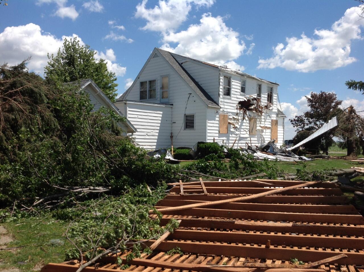 |
| A home damaged by a June 13, 2013 EF-1 tornado in Henry County, Ohio (NWS photo) |
The northern Indiana office of the National Weather Service posted more information last evening from its storm damage survey teams. The full report is on the office’s website, but I’ve posted below the map graphics that show the storm paths the teams found.


NWS survey teams publish preliminary damage reports

This afternoon, the northern Indiana National Weather Service office published the following preliminary report from official surveys of areas damaged by last night’s storms:
PUBLIC INFORMATION STATEMENT
NATIONAL WEATHER SERVICE NORTHERN INDIANA
1254 PM EDT THU JUN 13 2013 /1154 AM CDT THU JUN 13 2013/

...UPDATE ON JUNE 12 SEVERE WEATHER DAMAGE SURVEYS...

ALL INFORMATION IS CONSIDERED PRELIMINARY AND SUBJECT TO CHANGE.

A COMBINATION OF SUPERCELL THUNDERSTORMS AND BOWING LINE SEGMENTS
WITH MANY AREAS OF ROTATION MOVED THROUGH NORTHERN INDIANA AND
NORTHWEST OHIO DURING THE EVENING AND OVERNIGHT HOURS OF
WEDNESDAY...JUNE 12. THE NATIONAL WEATHER SERVICE IN NORTHERN
INDIANA DISPATCHED TWO DAMAGE SURVEY CREWS TO VARIOUS PARTS OF THE
COUNTY WARNING AREA TO DETERMINE THE NATURE AND EXTENT OF THESE
STORMS.  REPORTS FROM THESE TEAMS FOLLOW.

...WABASH /WABASH COUNTY/...

NATURE: STRAIGHT LINE WINDS
TIME: 1047 PM EDT (ESTIMATED BY RADAR)
LOCATION: NORTHWEST SIDE OF THE TOWN OF WABASH
WIND SPEED: ESTIMATED 90 TO 100 MPH WINDS
DESCRIPTION: A GRAIN SILO AND 2 POLE BARNS WERE COMPLETELY
DESTROYED WITH DEBRIS BLOWN SOUTHEAST. EXTENSIVE TREE DAMAGE WAS
FOUND ON THE NORTHWEST SIDE OF WABASH.

...TORNADO /VAN WERT COUNTY/...
RATING: EF0
MAXIMUM ESTIMATED WIND SPEED: 80 MPH
PATH LENGTH: 0.2 MILES PATH
WIDTH /MAXIMUM/: 80 YARDS
TIME: 1127 PM EDT
LOCATION: WILLSHIRE OHIO /GREEN STREET FROM WILLIAMS STREET TO SR
49/
DESCRIPTION: A WEAK EF0 TORNADO TOUCHED DOWN ON THE SOUTH SIDE
OF THE TOWN OF WILLSHIRE AT THE INTERSECTION OF GREEN STREET AND
WILLIAMS STREET AND CONTINUED 3 BLOCKS EAST TO THE INTERSECTION OF
GREEN STREET AND SR 49. ONE WITNESS SAW TORNADO DESCEND IN HIS
YARD...SNAP OFF 2 LARGE TREES AND CONTINUE DOWN THE STREET. OTHER
TREE DAMAGE WAS NOTED. A FEW HOMES SUSTAINED MAJOR ROOF AND WINDOW
DAMAGE. A FREE STANDING GARAGE WAS ROLLED OFF OF CINDER BLOCK
FOUNDATION. TORNADO WAS ON THE GROUND FOR LESS THAN 2 MINUTES.
MAXIMUM WIND SPEEDS ESTIMATED AT 80 MPH.

...HENRY COUNTY OHIO DAMAGE...

SURVEY IS IN PROGRESS AND DETAILS WILL BE RELAYED AS THEY BECOME
AVAILABLE.
NWS deploys teams to asses possible tornado damage
The following is a public information statement the northern Indiana National Weather Service office issued. Sorry about the caps, that’s how NWS sends these and I don’t have time to re-capitalize.
PUBLIC INFORMATION STATEMENT
NATIONAL WEATHER SERVICE NORTHERN INDIANA
1101 AM EDT THU JUN 13 2013 /1001 AM CDT THU JUN 13 2013/

...DAMAGE SURVEYS BEING CONDUCTED TODAY...

THE NATIONAL WEATHER SERVICE IN NORTHERN INDIANA HAS DEPLOYED TWO
DAMAGE ASSESSMENT TEAMS TO SURVEY POSSIBLE TORNADO DAMAGE FROM LAST
NIGHTS SEVERE WEATHER. ONE TEAM HAS DEPLOYED TO WABASH INDIANA
AND WILL BE WORKING IN CONJUNCTION WITH WABASH COUNTY EMERGENCY
MANAGEMENT. THE SECOND TEAM HAS DEPLOYED TO HENRY COUNTY OHIO AND
WILL BE WORKING IN CONJUNCTION WITH HENRY COUNTY EMERGENCY
MANAGEMENT. VAN WERT COUNTY OHIO EMERGENCY MANAGEMENT IS SURVEYING
A THIRD AREA OF DAMAGE IN THE TOWN OF WILLSHIRE IN SOUTHERN VAN
WERT COUNTY. THEY WILL BE WORKING IN CONJUNCTION WITH NWS
WILMINGTON.

RESULTS FROM THESE DAMAGE SURVEYS WILL BE PUBLISHED AS SOON AS
THEY BECOME AVAILABLE.

TO REPORT ADDITIONAL WIND DAMAGE...HAIL...OR FLOODING FROM THE
STORMS PLEASE POST TO THE NWS NORTHERN INDIANA FACEBOOK
PAGE...TWEET TO @NWSIWX...OR SEND AN EMAIL TO OUR WEBMASTER AT
W-IWX.WEBMASTER@NOAA.GOV.